Property Record
2007 W Main St, Atlanta, TX 75551


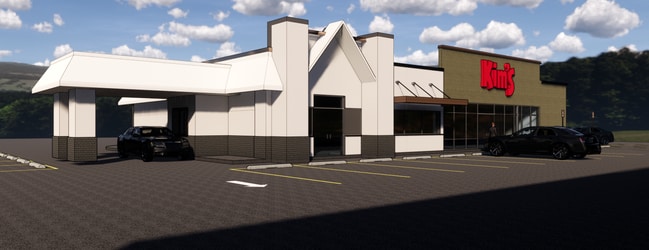
Property Detail
2007 W Main St
21733
BIG TOWN VILLAGE BLK 1 LOT 6-10 2.1451 AC 40625
Commercialnec
Cass
B and X Area of moderate flood hazard, usually the area between the limits of the 100-year and 500-year floods.
Texas
2025
6-10
2025
2.15 AC
950400
Texas East Area
11,868 SF
Other Market Areas
NEARBY LISTINGS FOR SALE OR LEASE
DEMOGRAPHICS near 2007 W Main St
1 mile
3 mile
5 mile
2025 Total Population
488
5,710
8,963
2030 Population
484
5,661
8,891
Pop Growth 2025-2030
(0.82%)
(0.86%)
(0.80%)
Average Age
42
42
42
2025 Total Households
201
2,286
3,636
HH Growth 2025-2030
(1.00%)
(0.83%)
(0.80%)
Median Household Inc
$72,499
$63,956
$64,105
Avg Household Size
2.40
2.40
2.40
2025 Avg HH Vehicles
2.00
2.00
2.00
Median Home Value
$206,452
$174,199
$170,459
Median Year Built
1976
1976
1978
Nearby Places
Map Layers
Map Styles
 Street
 Aerial
Layers
 Traffic
 Biking
Places
Listings with unknown addresses are not visible on the map
- Restaurants
- Banks
- Shops
- Fitness
- Groceries
PUBLIC TRANSPORTATION
AIRPORT
Texarkana Regional-Webb Field
Drive
Walk
Distance
Texarkana Regional-Webb Field
42 min
32.6 mi
Freight Ports
Port of Shreveport
Drive
Walk
Distance
Port of Shreveport
102 min
80.6 mi
SALE & LEASE HISTORY
LISTING DATE
SALE/LEASE

Oct 21, 2019
For Sale
May 19, 2017
For Sale
Nearby Properties
Address
Land Use
TOTAL SIZE
Lot Size
Zoning
Address
Land Use
TOTAL SIZE
Lot Size
Zoning
122,355 SF
20.53 AC
Address
Land Use
TOTAL SIZE
Lot Size
Zoning
93,957 SF
19.71 AC
Address
Land Use
TOTAL SIZE
Lot Size
Zoning
65,178 SF
21.07 AC
Address
Land Use
TOTAL SIZE
Lot Size
Zoning
65,730 SF
7.55 AC
Address
Land Use
TOTAL SIZE
Lot Size
Zoning
158,090 SF
19.11 AC
Address
Land Use
TOTAL SIZE
Lot Size
Zoning
62,914 SF
36.58 AC
Address
Land Use
TOTAL SIZE
Lot Size
Zoning
36,049 SF
20.28 AC
Address
Land Use
TOTAL SIZE
Lot Size
Zoning
Address
Land Use
TOTAL SIZE
Lot Size
Zoning
41,570 SF
1 AC
Address
Land Use
TOTAL SIZE
Lot Size
Zoning
72,109 SF
6.60 AC
Address
Land Use
TOTAL SIZE
Lot Size
Zoning
88,077 SF
19.52 AC
Address
Land Use
TOTAL SIZE
Lot Size
Zoning
50,452 SF
45.60 AC
Address
Land Use
TOTAL SIZE
Lot Size
Zoning
34,436 SF
4.71 AC
Address
Land Use
TOTAL SIZE
Lot Size
Zoning
23,737 SF
1.26 AC
Address
Land Use
TOTAL SIZE
Lot Size
Zoning
28,474 SF
15.43 AC
Address
Land Use
TOTAL SIZE
Lot Size
Zoning
33,471 SF
3.93 AC
Address
Land Use
TOTAL SIZE
Lot Size
Zoning
19,950 SF
3 AC
Address
Land Use
TOTAL SIZE
Lot Size
Zoning
24,664 SF
6.50 AC
Address
Land Use
TOTAL SIZE
Lot Size
Zoning
18,483 SF
1.47 AC
Address
Land Use
TOTAL SIZE
Lot Size
Zoning
39,572 SF
3.53 AC
Address
Land Use
TOTAL SIZE
Lot Size
Zoning
13,707 SF
1.25 AC
Address
Land Use
TOTAL SIZE
Lot Size
Zoning
12,848 SF
3 AC
Address
Land Use
TOTAL SIZE
Lot Size
Zoning
Address
Land Use
TOTAL SIZE
Lot Size
Zoning
11,215 SF
4 AC
Address
Land Use
TOTAL SIZE
Lot Size
Zoning
17,336 SF
1.08 AC
Address
Land Use
TOTAL SIZE
Lot Size
Zoning
13,069 SF
1.36 AC
Address
Land Use
TOTAL SIZE
Lot Size
Zoning
13,944 SF
16 AC
Address
Land Use
TOTAL SIZE
Lot Size
Zoning
17,481 SF
1.41 AC
Address
Land Use
TOTAL SIZE
Lot Size
Zoning
26,432 SF
4.64 AC
Address
Land Use
TOTAL SIZE
Lot Size
Zoning
14,920 SF
11.85 AC
The World's #1 Commercial Real Estate Marketplace
Connect with us
© 2026 CoStar Group
The information above has been obtained from sources believed reliable. While we do not doubt its accuracy we have not verified it and make no guarantee, warranty or representation about it. It is your responsibility to independently confirm its accuracy and completeness. Any projections, opinions, assumptions, or estimates used are for example only and do not represent the current or future performance of the property. The value of this transaction to you depends on tax and other factors which should be evaluated by your tax, financial, and legal advisors. You and your advisors should conduct a careful, independent investigation of the property to determine to your satisfaction the suitability of the property for your needs.