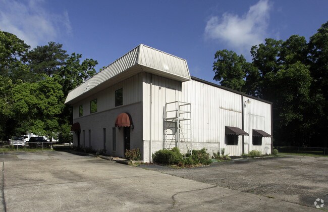
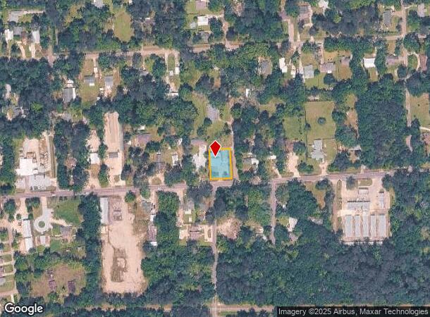
Property Record
20081 Highway 36, Covington, LA 70433
NEARBY LISTINGS FOR SALE OR LEASE
Property Detail
20081 Highway 36
Slidell-Mandeville-Covington, LA
Commercial Hwy 36
129491
PT LOT 8 SQ 7 GARLAND ADD MEAS 100X140 CB 1151 23 CB 1289 774 INST NO 948038 INST NO 1290832 INST NO 1641404
Commercialnec
St Tammany
ARE
Louisiana
2025
8
2024
0.32 AC
040502
Mandeville/Covington
6,000 SF
New Orleans/Metairie/Kenner
DEMOGRAPHICS near 20081 Highway 36
1 Mile
3 Mile
5 Mile
2024 Total Population
2,971
31,264
58,748
2029 Population
3,230
33,664
63,355
Pop Growth 2024-2029
+ 8.72%
+ 7.68%
+ 7.84%
Average Age
41
41
41
2024 Total Households
1,196
12,686
23,460
HH Growth 2024-2029
+ 8.86%
+ 7.66%
+ 7.82%
Median Household Inc
$60,577
$66,717
$71,085
Avg Household Size
2.40
2.40
2.40
2024 Avg HH Vehicles
2.00
2.00
2.00
Median Home Value
$287,777
$254,999
$281,795
Median Year Built
1993
1994
1997
Nearby Places
Map Layers
Map Styles
 Street
 Aerial
- Restaurants
- Banks
- Shops
- Fitness
- Groceries
PUBLIC TRANSPORTATION
AIRPORT
Louis Armstrong New Orleans International
DRIVE
WALK
Distance
Louis Armstrong New Orleans International
57 min
42.2 mi
Freight Ports
Port of New Orleans
DRIVE
WALK
Distance
Port of New Orleans
61 min
43.3 mi
SALE & LEASE HISTORY
LISTING DATE
SALE/LEASE

Sep 23, 2016
For Sale
Jun 14, 2018
For Lease
Nearby Properties
Address
Land Use
TOTAL SIZE
Lot Size
Zoning
Address
Land Use
TOTAL SIZE
Lot Size
Zoning
515,547 SF
20.54 AC
Address
Land Use
TOTAL SIZE
Lot Size
Zoning
200,000 SF
0.28 AC
Address
Land Use
TOTAL SIZE
Lot Size
Zoning
86,167 SF
0.71 AC
Address
Land Use
TOTAL SIZE
Lot Size
Zoning
171,138 SF
13.02 AC
Address
Land Use
TOTAL SIZE
Lot Size
Zoning
102,470 SF
10.50 AC
Address
Land Use
TOTAL SIZE
Lot Size
Zoning
205,612 SF
23.60 AC
Address
Land Use
TOTAL SIZE
Lot Size
Zoning
147,611 SF
22 AC
Address
Land Use
TOTAL SIZE
Lot Size
Zoning
38,976 SF
6.80 AC
Address
Land Use
TOTAL SIZE
Lot Size
Zoning
92,535 SF
2.80 AC
Address
Land Use
TOTAL SIZE
Lot Size
Zoning
114,823 SF
4.57 AC
Address
Land Use
TOTAL SIZE
Lot Size
Zoning
124,002 SF
20.55 AC
Address
Land Use
TOTAL SIZE
Lot Size
Zoning
121,705 SF
21.20 AC
Address
Land Use
TOTAL SIZE
Lot Size
Zoning
86,688 SF
3.75 AC
Address
Land Use
TOTAL SIZE
Lot Size
Zoning
106,915 SF
20 AC
Address
Land Use
TOTAL SIZE
Lot Size
Zoning
114,727 SF
4.46 AC
Address
Land Use
TOTAL SIZE
Lot Size
Zoning
Address
Land Use
TOTAL SIZE
Lot Size
Zoning
101,007 SF
6 AC
Address
Land Use
TOTAL SIZE
Lot Size
Zoning
97,331 SF
25.37 AC
Address
Land Use
TOTAL SIZE
Lot Size
Zoning
42,513 SF
7.07 AC
Address
Land Use
TOTAL SIZE
Lot Size
Zoning
94,300 SF
15.21 AC
Address
Land Use
TOTAL SIZE
Lot Size
Zoning
148,494 SF
15.43 AC
Address
Land Use
TOTAL SIZE
Lot Size
Zoning
142 SF
2 AC
Address
Land Use
TOTAL SIZE
Lot Size
Zoning
50,819 SF
18.80 AC
Address
Land Use
TOTAL SIZE
Lot Size
Zoning
46,570 SF
2 AC
Address
Land Use
TOTAL SIZE
Lot Size
Zoning
107,528 SF
11.24 AC
Address
Land Use
TOTAL SIZE
Lot Size
Zoning
83,292 SF
6.27 AC
Address
Land Use
TOTAL SIZE
Lot Size
Zoning
38,794 SF
2.79 AC
Address
Land Use
TOTAL SIZE
Lot Size
Zoning
37,377 SF
2.81 AC
Address
Land Use
TOTAL SIZE
Lot Size
Zoning
18,271 SF
0.13 AC
Address
Land Use
TOTAL SIZE
Lot Size
Zoning
100,990 SF
13.80 AC
The World's #1 Commercial Real Estate Marketplace
Connect with us
© 2026 CoStar Group
The information above has been obtained from sources believed reliable. While we do not doubt its accuracy we have not verified it and make no guarantee, warranty or representation about it. It is your responsibility to independently confirm its accuracy and completeness. Any projections, opinions, assumptions, or estimates used are for example only and do not represent the current or future performance of the property. The value of this transaction to you depends on tax and other factors which should be evaluated by your tax, financial, and legal advisors. You and your advisors should conduct a careful, independent investigation of the property to determine to your satisfaction the suitability of the property for your needs.