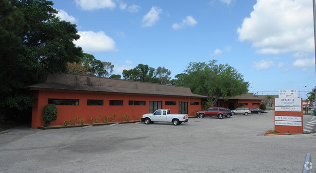
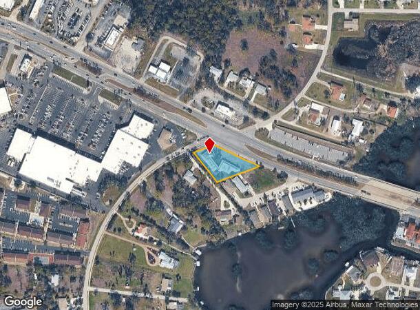
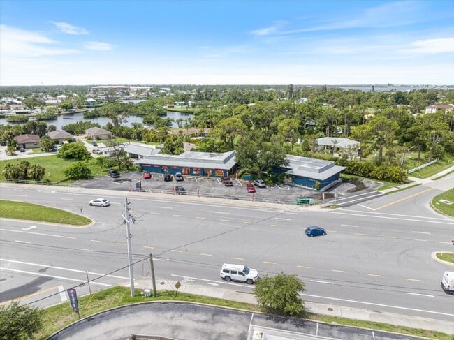
Property Record
2009 S Mccall Rd, Englewood, FL 34223
NEARBY LISTINGS FOR SALE OR LEASE
Property Detail
2009 S Mccall Rd
Punta Gorda, FL
Manor Sub
412005304001
MANOR SUB LTS 11 12 13 388/479 388/480 409/855 409/856 562/1976 1436/287 1436/290 1749/267
Medicalbuilding
Charlotte
AE
Florida
12015C0187G
11
2024
0.76 AC
2025
Charlotte County
030301
Southwest Florida
8,891 SF
DEMOGRAPHICS near 2009 S Mccall Rd
1 Mile
3 Mile
5 Mile
2024 Total Population
4,459
24,034
46,545
2029 Population
5,416
28,896
55,806
Pop Growth 2024-2029
+ 21.46%
+ 20.23%
+ 19.90%
Average Age
59
59
58
2024 Total Households
2,243
12,467
23,653
HH Growth 2024-2029
+ 21.85%
+ 20.49%
+ 20.09%
Median Household Inc
$55,706
$55,761
$56,318
Avg Household Size
1.90
1.90
1.90
2024 Avg HH Vehicles
1.00
2.00
2.00
Median Home Value
$268,453
$268,404
$267,660
Median Year Built
1978
1982
1986
Nearby Places
Map Layers
Map Styles
 Street
 Aerial
- Restaurants
- Banks
- Shops
- Fitness
- Groceries
PUBLIC TRANSPORTATION
AIRPORT
Punta Gorda
DRIVE
WALK
Distance
Punta Gorda
45 min
27.5 mi
Freight Ports
Port Manatee
DRIVE
WALK
Distance
Port Manatee
74 min
55.6 mi
SALE & LEASE HISTORY
LISTING DATE
SALE/LEASE

Sep 24, 2016
For Lease
Oct 22, 2021
For Sale
Oct 08, 2021
For Lease
Jan 14, 2021
For Sale
Feb 18, 2020
For Lease
Feb 14, 2020
For Sale
Nearby Properties
Address
Land Use
TOTAL SIZE
Lot Size
Zoning
Address
Land Use
TOTAL SIZE
Lot Size
Zoning
796,848 SF
44.28 AC
RE1
Address
Land Use
TOTAL SIZE
Lot Size
Zoning
95,649 SF
10.41 AC
OPI
Address
Land Use
TOTAL SIZE
Lot Size
Zoning
193,100 SF
26.30 AC
PD
Address
Land Use
TOTAL SIZE
Lot Size
Zoning
55,952 SF
4.69 AC
MMF7.5
Address
Land Use
TOTAL SIZE
Lot Size
Zoning
73,356 SF
8.98 AC
GU
Address
Land Use
TOTAL SIZE
Lot Size
Zoning
30,565 SF
136.67 AC
GU
Address
Land Use
TOTAL SIZE
Lot Size
Zoning
28,490 SF
172 AC
PKR
Address
Land Use
TOTAL SIZE
Lot Size
Zoning
33,654 SF
10.19 AC
RMF5
Address
Land Use
TOTAL SIZE
Lot Size
Zoning
91,934 SF
8.39 AC
PD
Address
Land Use
TOTAL SIZE
Lot Size
Zoning
112,350 SF
2.84 AC
CG
Address
Land Use
TOTAL SIZE
Lot Size
Zoning
103,161 SF
2.54 AC
ILW
Address
Land Use
TOTAL SIZE
Lot Size
Zoning
111,505 SF
9.53 AC
CG
Address
Land Use
TOTAL SIZE
Lot Size
Zoning
6,061 SF
13.72 AC
MES
Address
Land Use
TOTAL SIZE
Lot Size
Zoning
95,900 SF
5.56 AC
RMF3
Address
Land Use
TOTAL SIZE
Lot Size
Zoning
70,165 SF
22.18 AC
CG
Address
Land Use
TOTAL SIZE
Lot Size
Zoning
58,185 SF
3.40 AC
IG
Address
Land Use
TOTAL SIZE
Lot Size
Zoning
71,462 SF
24.99 AC
RE1
Address
Land Use
TOTAL SIZE
Lot Size
Zoning
2,495 SF
6.97 AC
RMH
Address
Land Use
TOTAL SIZE
Lot Size
Zoning
89,501 SF
6.52 AC
CG
Address
Land Use
TOTAL SIZE
Lot Size
Zoning
50,672 SF
77.41 AC
RMF1
Address
Land Use
TOTAL SIZE
Lot Size
Zoning
25,777 SF
12.18 AC
PD
Address
Land Use
TOTAL SIZE
Lot Size
Zoning
55,760 SF
3.18 AC
CG
Address
Land Use
TOTAL SIZE
Lot Size
Zoning
25,478 SF
11.06 AC
IG
Address
Land Use
TOTAL SIZE
Lot Size
Zoning
42,228 SF
9.24 AC
RE1
Address
Land Use
TOTAL SIZE
Lot Size
Zoning
72,168 SF
7.11 AC
CG
Address
Land Use
TOTAL SIZE
Lot Size
Zoning
1,459 SF
11.21 AC
RSF4
Address
Land Use
TOTAL SIZE
Lot Size
Zoning
38,753 SF
8.78 AC
OPI
Address
Land Use
TOTAL SIZE
Lot Size
Zoning
44,594 SF
5.70 AC
CG
Address
Land Use
TOTAL SIZE
Lot Size
Zoning
35,351 SF
7.44 AC
CG
Address
Land Use
TOTAL SIZE
Lot Size
Zoning
3.13 AC
RE2
The World's #1 Commercial Real Estate Marketplace
Connect with us
© 2026 CoStar Group
The information above has been obtained from sources believed reliable. While we do not doubt its accuracy we have not verified it and make no guarantee, warranty or representation about it. It is your responsibility to independently confirm its accuracy and completeness. Any projections, opinions, assumptions, or estimates used are for example only and do not represent the current or future performance of the property. The value of this transaction to you depends on tax and other factors which should be evaluated by your tax, financial, and legal advisors. You and your advisors should conduct a careful, independent investigation of the property to determine to your satisfaction the suitability of the property for your needs.