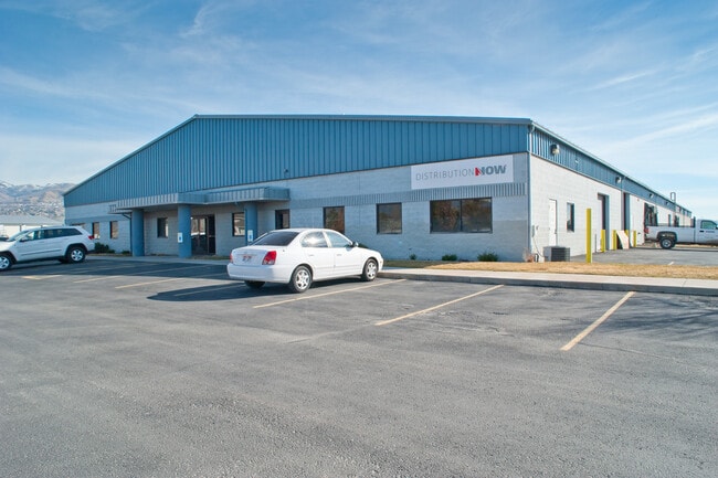
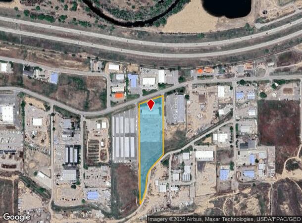
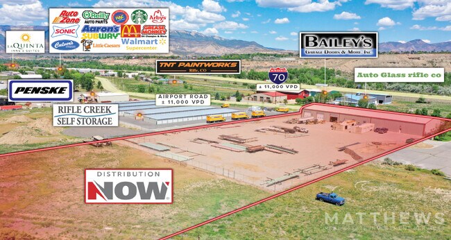
Property Record
2009 Airport Rd, Rifle, CO 81650
NEARBY LISTINGS FOR SALE OR LEASE
Property Detail
2009 Airport Rd
Other Market Areas
Goldberg-Tarasiuk Minor Sub
Glenwood Springs, CO
SECTION: 15 TOWNSHIP: 6 RANGE: 93 SUBDIVISION: GOLDBERG-TARASIUK MINOR SUB LOT: 1 AS PER AMENDED FINAL PLAT RECEPTION NO.
R084446
Garfield
Publicstorage
Colorado
2024
1
2024
5.78 AC
952003
Colorado Northwest Area
DEMOGRAPHICS near 2009 Airport Rd
1 Mile
3 Mile
5 Mile
2024 Total Population
58
12,636
13,947
2029 Population
60
12,979
14,315
Pop Growth 2024-2029
+ 3.45%
+ 2.71%
+ 2.64%
Average Age
37
35
36
2024 Total Households
20
4,264
4,696
HH Growth 2024-2029
0.00%
+ 2.65%
+ 2.60%
Median Household Inc
$95,833
$76,002
$76,934
Avg Household Size
2.80
2.80
2.90
2024 Avg HH Vehicles
3.00
2.00
3.00
Median Home Value
$374,999
$342,139
$351,513
Median Year Built
1979
1987
1987
Nearby Places
Map Layers
Map Styles
 Street
 Aerial
- Restaurants
- Banks
- Shops
- Fitness
- Groceries
SALE & LEASE HISTORY
LISTING DATE
SALE/LEASE

May 28, 2021
For Sale
Nearby Properties
Address
Land Use
TOTAL SIZE
Lot Size
Zoning
Address
Land Use
TOTAL SIZE
Lot Size
Zoning
13,020 SF
539.51 AC
PA
Address
Land Use
TOTAL SIZE
Lot Size
Zoning
36,472 SF
24.71 AC
Address
Land Use
TOTAL SIZE
Lot Size
Zoning
25,912 SF
48.26 AC
PUD
Address
Land Use
TOTAL SIZE
Lot Size
Zoning
54,298 SF
1.70 AC
Address
Land Use
TOTAL SIZE
Lot Size
Zoning
141,376 SF
16.63 AC
Address
Land Use
TOTAL SIZE
Lot Size
Zoning
4,950 SF
2.18 AC
Address
Land Use
TOTAL SIZE
Lot Size
Zoning
12 AC
Address
Land Use
TOTAL SIZE
Lot Size
Zoning
19.18 AC
RL
Address
Land Use
TOTAL SIZE
Lot Size
Zoning
8,800 SF
13.69 AC
CG
Address
Land Use
TOTAL SIZE
Lot Size
Zoning
43,253 SF
1.95 AC
RS
Address
Land Use
TOTAL SIZE
Lot Size
Zoning
63,337 SF
2.41 AC
Address
Land Use
TOTAL SIZE
Lot Size
Zoning
1,660 SF
57.80 AC
R
Address
Land Use
TOTAL SIZE
Lot Size
Zoning
25,268 SF
3.74 AC
Address
Land Use
TOTAL SIZE
Lot Size
Zoning
Address
Land Use
TOTAL SIZE
Lot Size
Zoning
19,958 SF
0.03 AC
Address
Land Use
TOTAL SIZE
Lot Size
Zoning
4,439 SF
1.30 AC
Address
Land Use
TOTAL SIZE
Lot Size
Zoning
23,800 SF
1.50 AC
Address
Land Use
TOTAL SIZE
Lot Size
Zoning
13,024 SF
4.50 AC
Address
Land Use
TOTAL SIZE
Lot Size
Zoning
840 SF
2 AC
CG
Address
Land Use
TOTAL SIZE
Lot Size
Zoning
1,040 SF
3.95 AC
CG
Address
Land Use
TOTAL SIZE
Lot Size
Zoning
13.17 AC
Address
Land Use
TOTAL SIZE
Lot Size
Zoning
200 SF
9.83 AC
Address
Land Use
TOTAL SIZE
Lot Size
Zoning
16,968 SF
1.09 AC
Address
Land Use
TOTAL SIZE
Lot Size
Zoning
9,760 SF
4.08 AC
Address
Land Use
TOTAL SIZE
Lot Size
Zoning
6,386 SF
4.37 AC
Address
Land Use
TOTAL SIZE
Lot Size
Zoning
13,500 SF
1.46 AC
Address
Land Use
TOTAL SIZE
Lot Size
Zoning
12,888 SF
19.55 AC
PUD
Address
Land Use
TOTAL SIZE
Lot Size
Zoning
18,441 SF
1.09 AC
Address
Land Use
TOTAL SIZE
Lot Size
Zoning
46,573 SF
1.62 AC
The World's #1 Commercial Real Estate Marketplace
Connect with us
© 2025 CoStar Group
The information above has been obtained from sources believed reliable. While we do not doubt its accuracy we have not verified it and make no guarantee, warranty or representation about it. It is your responsibility to independently confirm its accuracy and completeness. Any projections, opinions, assumptions, or estimates used are for example only and do not represent the current or future performance of the property. The value of this transaction to you depends on tax and other factors which should be evaluated by your tax, financial, and legal advisors. You and your advisors should conduct a careful, independent investigation of the property to determine to your satisfaction the suitability of the property for your needs.