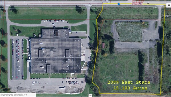
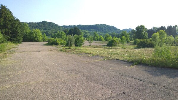
Property Record
2009 E State St, Athens, OH 45701


Property Detail
2009 E State St
E04-02801011-03
SEC 28 FRA 34 15.1893AC
Departmentstore
Athens
AE The base floodplain where base flood elevations are provided. AE Zones are now used on new format FIRMs instead of A1-A30 Zones.
Ohio
2024
15.19 AC
2024
Ohio South Area
973400
Other Market Areas
171,885 SF
Athens, OH
NEARBY LISTINGS FOR SALE OR LEASE
-
-
View all Athens listings for sale on LoopNet.com
DEMOGRAPHICS near 2009 E State St
1 mile
3 mile
5 mile
2024 Total Population
250
9,886
28,647
2029 Population
247
9,854
28,754
Pop Growth 2024-2029
(1.20%)
(0.32%)
+ 0.37%
Average Age
42
31
31
2024 Total Households
114
3,378
9,287
HH Growth 2024-2029
(0.88%)
(0.56%)
+ 0.13%
Median Household Inc
$74,999
$35,843
$41,413
Avg Household Size
2.20
2.20
2.20
2024 Avg HH Vehicles
2.00
2.00
2.00
Median Home Value
$287,036
$270,912
$248,336
Median Year Built
1960
1969
1976
Nearby Places
Map Layers
Map Styles
 Street
 Aerial
Transit
 Traffic
 Biking
Places
Listings with unknown addresses are not visible on the map
- Restaurants
- Banks
- Shops
- Fitness
- Groceries
SALE & LEASE HISTORY
LISTING DATE
SALE/LEASE

Mar 13, 2017
For Sale
Nearby Properties
Address
Land Use
TOTAL SIZE
Lot Size
Zoning
Address
Land Use
TOTAL SIZE
Lot Size
Zoning
270,480 SF
100.28 AC
Address
Land Use
TOTAL SIZE
Lot Size
Zoning
380,042 SF
11.62 AC
Address
Land Use
TOTAL SIZE
Lot Size
Zoning
10.06 AC
Address
Land Use
TOTAL SIZE
Lot Size
Zoning
43,469 SF
4.78 AC
Address
Land Use
TOTAL SIZE
Lot Size
Zoning
64,218 SF
8.65 AC
Address
Land Use
TOTAL SIZE
Lot Size
Zoning
150,578 SF
2.59 AC
Address
Land Use
TOTAL SIZE
Lot Size
Zoning
173,461 SF
12 AC
Address
Land Use
TOTAL SIZE
Lot Size
Zoning
113,828 SF
0.71 AC
Address
Land Use
TOTAL SIZE
Lot Size
Zoning
116,023 SF
0.85 AC
Address
Land Use
TOTAL SIZE
Lot Size
Zoning
99,964 SF
1.04 AC
Address
Land Use
TOTAL SIZE
Lot Size
Zoning
1,485 SF
23.99 AC
Address
Land Use
TOTAL SIZE
Lot Size
Zoning
7.25 AC
Address
Land Use
TOTAL SIZE
Lot Size
Zoning
127,035 SF
0.55 AC
Address
Land Use
TOTAL SIZE
Lot Size
Zoning
70,283 SF
0.45 AC
Address
Land Use
TOTAL SIZE
Lot Size
Zoning
258,656 SF
72.80 AC
Address
Land Use
TOTAL SIZE
Lot Size
Zoning
124,617 SF
2.10 AC
Address
Land Use
TOTAL SIZE
Lot Size
Zoning
66,252 SF
2.37 AC
Address
Land Use
TOTAL SIZE
Lot Size
Zoning
93,697 SF
7.62 AC
Address
Land Use
TOTAL SIZE
Lot Size
Zoning
127,478 SF
0.92 AC
Address
Land Use
TOTAL SIZE
Lot Size
Zoning
716 SF
5 AC
Address
Land Use
TOTAL SIZE
Lot Size
Zoning
Address
Land Use
TOTAL SIZE
Lot Size
Zoning
4.71 AC
Address
Land Use
TOTAL SIZE
Lot Size
Zoning
4.24 AC
Address
Land Use
TOTAL SIZE
Lot Size
Zoning
14.79 AC
Address
Land Use
TOTAL SIZE
Lot Size
Zoning
42,786 SF
3.14 AC
Address
Land Use
TOTAL SIZE
Lot Size
Zoning
227,980 SF
19.55 AC
Address
Land Use
TOTAL SIZE
Lot Size
Zoning
47,611 SF
4.33 AC
Address
Land Use
TOTAL SIZE
Lot Size
Zoning
44,068 SF
1.57 AC
Address
Land Use
TOTAL SIZE
Lot Size
Zoning
67,726 SF
3.79 AC
The World's #1 Commercial Real Estate Marketplace
Connect with us
© 2026 CoStar Group
The information above has been obtained from sources believed reliable. While we do not doubt its accuracy we have not verified it and make no guarantee, warranty or representation about it. It is your responsibility to independently confirm its accuracy and completeness. Any projections, opinions, assumptions, or estimates used are for example only and do not represent the current or future performance of the property. The value of this transaction to you depends on tax and other factors which should be evaluated by your tax, financial, and legal advisors. You and your advisors should conduct a careful, independent investigation of the property to determine to your satisfaction the suitability of the property for your needs.