Property Record
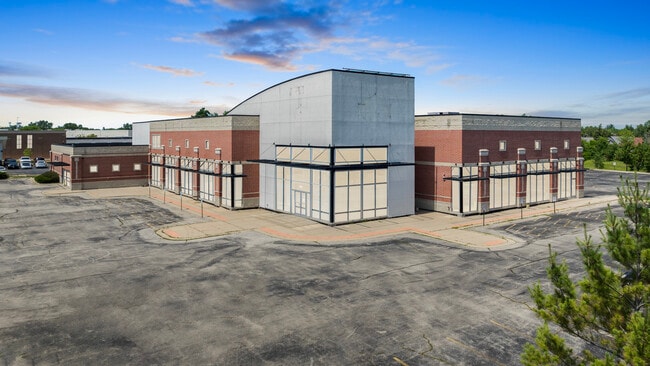
2009 N Rand Rd, Palatine, IL 60074

This Property Is For Sale
NEARBY LISTINGS FOR SALE OR LEASE
Property Detail
2009 N Rand Rd
02-02-203-067-0000
Harley Consolidation
Commercialbuilding
Cook
X
Illinois
17097C0244K
4.36 AC
2023
Schaumburg Area
2024
Chicago
803608
Chicago-Naperville-Elgin, IL-IN-WI
27,560 SF
DEMOGRAPHICS near 2009 N Rand Rd
1 Mile
3 Mile
5 Mile
2024 Total Population
18,196
97,232
237,782
2029 Population
17,695
94,904
232,024
Pop Growth 2024-2029
(2.75%)
(2.39%)
(2.42%)
Average Age
37
41
42
2024 Total Households
6,633
38,315
90,203
HH Growth 2024-2029
(3.06%)
(2.70%)
(2.73%)
Median Household Inc
$62,425
$93,098
$106,443
Avg Household Size
2.70
2.50
2.60
2024 Avg HH Vehicles
2.00
2.00
2.00
Median Home Value
$208,205
$343,372
$365,193
Median Year Built
1978
1977
1977
Nearby Places
Map Layers
Map Styles
 Street
 Aerial
- Restaurants
- Banks
- Shops
- Fitness
- Groceries
PUBLIC TRANSPORTATION
COMMUTER RAIL
Palatine Station (Union Pacific Northwest Line - Northeast Illinois Regional Commuter Railroad (Metra))
DRIVE
WALK
Distance
Palatine Station (Union Pacific Northwest Line - Northeast Illinois Regional Commuter Railroad (Metra))
10 min
4.3 mi
Arlington Park Station (Union Pacific Northwest Line - Northeast Illinois Regional Commuter Railroad (Metra))
DRIVE
WALK
Distance
Arlington Park Station (Union Pacific Northwest Line - Northeast Illinois Regional Commuter Railroad (Metra))
12 min
5.8 mi
AIRPORT
Chicago O'Hare International
DRIVE
WALK
Distance
Chicago O'Hare International
48 min
21.7 mi
Chicago Midway International
DRIVE
WALK
Distance
Chicago Midway International
62 min
37.6 mi
Nearby Properties
Address
Land Use
TOTAL SIZE
Lot Size
Zoning
Address
Land Use
TOTAL SIZE
Lot Size
Zoning
32.49 AC
Address
Land Use
TOTAL SIZE
Lot Size
Zoning
11.24 AC
Address
Land Use
TOTAL SIZE
Lot Size
Zoning
12.86 AC
Address
Land Use
TOTAL SIZE
Lot Size
Zoning
622,896 SF
3.94 AC
Address
Land Use
TOTAL SIZE
Lot Size
Zoning
787,336 SF
Address
Land Use
TOTAL SIZE
Lot Size
Zoning
Address
Land Use
TOTAL SIZE
Lot Size
Zoning
Address
Land Use
TOTAL SIZE
Lot Size
Zoning
Address
Land Use
TOTAL SIZE
Lot Size
Zoning
Address
Land Use
TOTAL SIZE
Lot Size
Zoning
214,428 SF
17.29 AC
Address
Land Use
TOTAL SIZE
Lot Size
Zoning
24.86 AC
Address
Land Use
TOTAL SIZE
Lot Size
Zoning
Address
Land Use
TOTAL SIZE
Lot Size
Zoning
449,131 SF
28.93 AC
Address
Land Use
TOTAL SIZE
Lot Size
Zoning
14,099 SF
2.01 AC
Address
Land Use
TOTAL SIZE
Lot Size
Zoning
197,097 SF
21.80 AC
Address
Land Use
TOTAL SIZE
Lot Size
Zoning
Address
Land Use
TOTAL SIZE
Lot Size
Zoning
392,574 SF
25.82 AC
Address
Land Use
TOTAL SIZE
Lot Size
Zoning
102,425 SF
9.38 AC
Address
Land Use
TOTAL SIZE
Lot Size
Zoning
152,838 SF
10.05 AC
Address
Land Use
TOTAL SIZE
Lot Size
Zoning
4,000 SF
1.41 AC
Address
Land Use
TOTAL SIZE
Lot Size
Zoning
151,643 SF
11.18 AC
Address
Land Use
TOTAL SIZE
Lot Size
Zoning
0.99 AC
Address
Land Use
TOTAL SIZE
Lot Size
Zoning
7.97 AC
Address
Land Use
TOTAL SIZE
Lot Size
Zoning
493,632 SF
31.51 AC
Address
Land Use
TOTAL SIZE
Lot Size
Zoning
129,789 SF
13.57 AC
Address
Land Use
TOTAL SIZE
Lot Size
Zoning
Address
Land Use
TOTAL SIZE
Lot Size
Zoning
18.36 AC
Address
Land Use
TOTAL SIZE
Lot Size
Zoning
Address
Land Use
TOTAL SIZE
Lot Size
Zoning
118,631 SF
9.65 AC
Address
Land Use
TOTAL SIZE
Lot Size
Zoning
5.27 AC
The World's #1 Commercial Real Estate Marketplace
Connect with us
© 2025 CoStar Group
The information above has been obtained from sources believed reliable. While we do not doubt its accuracy we have not verified it and make no guarantee, warranty or representation about it. It is your responsibility to independently confirm its accuracy and completeness. Any projections, opinions, assumptions, or estimates used are for example only and do not represent the current or future performance of the property. The value of this transaction to you depends on tax and other factors which should be evaluated by your tax, financial, and legal advisors. You and your advisors should conduct a careful, independent investigation of the property to determine to your satisfaction the suitability of the property for your needs.