Property Record
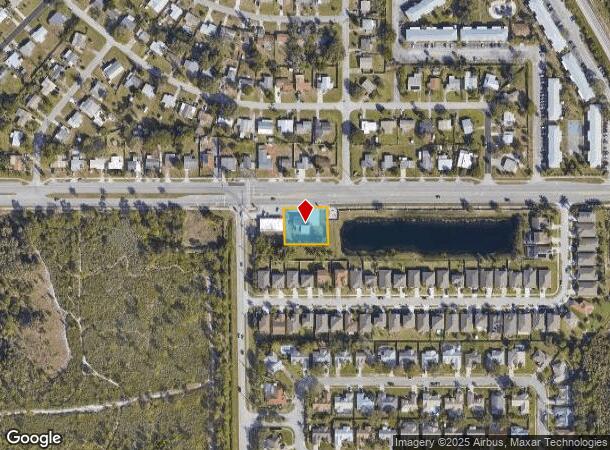
2009 Post Rd, Melbourne, FL 32935
NEARBY LISTINGS FOR SALE OR LEASE
-
-
View all Melbourne listings for sale on LoopNet.com
Property Detail
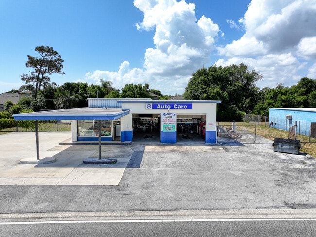
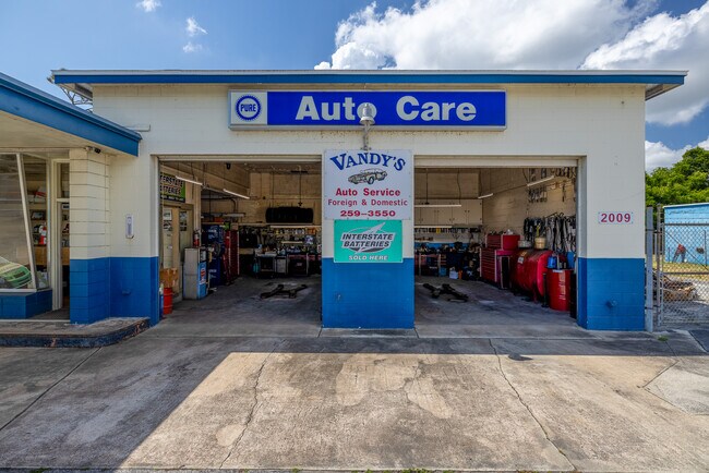
2009 Post Rd
27-37-05-00-00250.0-0000.00
Acreage
Autorepair
PART OF W 1/2 OF NW 1/4 AS DESC IN ORB 347 PG 519
X
Brevard
12009C0517H
Florida
2024
0.43 AC
2025
Brevard County
064124
Orlando
2,314 SF
Palm Bay-Melbourne-Titusville, FL
DEMOGRAPHICS near 2009 Post Rd
1 Mile
3 Mile
5 Mile
2024 Total Population
6,680
45,305
110,861
2029 Population
7,223
49,133
120,928
Pop Growth 2024-2029
+ 8.13%
+ 8.45%
+ 9.08%
Average Age
45
44
45
2024 Total Households
2,907
19,689
47,723
HH Growth 2024-2029
+ 7.88%
+ 8.20%
+ 8.86%
Median Household Inc
$57,138
$72,384
$75,899
Avg Household Size
2.20
2.20
2.30
2024 Avg HH Vehicles
2.00
2.00
2.00
Median Home Value
$224,593
$281,203
$314,350
Median Year Built
1981
1988
1984
Nearby Places
Map Layers
Map Styles
 Street
 Aerial
- Restaurants
- Banks
- Shops
- Fitness
- Groceries
PUBLIC TRANSPORTATION
AIRPORT
Melbourne Orlando International
DRIVE
WALK
Distance
Melbourne Orlando International
18 min
8.3 mi
Freight Ports
Port Canaveral
DRIVE
WALK
Distance
Port Canaveral
37 min
20.7 mi
SALE & LEASE HISTORY
LISTING DATE
SALE/LEASE

May 06, 2024
For Sale
Nearby Properties
Address
Land Use
TOTAL SIZE
Lot Size
Zoning
Address
Land Use
TOTAL SIZE
Lot Size
Zoning
676,548 SF
117.62 AC
I1
Address
Land Use
TOTAL SIZE
Lot Size
Zoning
438,381 SF
25.66 AC
R2
Address
Land Use
TOTAL SIZE
Lot Size
Zoning
363,826 SF
25.61 AC
RA
Address
Land Use
TOTAL SIZE
Lot Size
Zoning
236,982 SF
39.26 AC
EU2
Address
Land Use
TOTAL SIZE
Lot Size
Zoning
360,921 SF
85.76 AC
R2
Address
Land Use
TOTAL SIZE
Lot Size
Zoning
269,111 SF
21.79 AC
PUD
Address
Land Use
TOTAL SIZE
Lot Size
Zoning
328,357 SF
34.11 AC
I1
Address
Land Use
TOTAL SIZE
Lot Size
Zoning
216,446 SF
14.09 AC
R2
Address
Land Use
TOTAL SIZE
Lot Size
Zoning
222,779 SF
22.58 AC
R2
Address
Land Use
TOTAL SIZE
Lot Size
Zoning
188,237 SF
13.97 AC
R2
Address
Land Use
TOTAL SIZE
Lot Size
Zoning
253,120 SF
16.02 AC
R2
Address
Land Use
TOTAL SIZE
Lot Size
Zoning
188,093 SF
13.11 AC
R2
Address
Land Use
TOTAL SIZE
Lot Size
Zoning
227,172 SF
26.78 AC
BU1
Address
Land Use
TOTAL SIZE
Lot Size
Zoning
131,585 SF
10 AC
R2
Address
Land Use
TOTAL SIZE
Lot Size
Zoning
218,739 SF
11.23 AC
R2
Address
Land Use
TOTAL SIZE
Lot Size
Zoning
200,878 SF
16.41 AC
R2
Address
Land Use
TOTAL SIZE
Lot Size
Zoning
132,340 SF
14.58 AC
R2
Address
Land Use
TOTAL SIZE
Lot Size
Zoning
142,230 SF
13.33 AC
C1
Address
Land Use
TOTAL SIZE
Lot Size
Zoning
102,972 SF
18 AC
R2(6)
Address
Land Use
TOTAL SIZE
Lot Size
Zoning
97,430 SF
51.89 AC
BU1
Address
Land Use
TOTAL SIZE
Lot Size
Zoning
171,773 SF
8.02 AC
R2
Address
Land Use
TOTAL SIZE
Lot Size
Zoning
184,197 SF
12 AC
R1AAA
Address
Land Use
TOTAL SIZE
Lot Size
Zoning
87,681 SF
11.53 AC
I1
Address
Land Use
TOTAL SIZE
Lot Size
Zoning
147,729 SF
9.32 AC
I1
Address
Land Use
TOTAL SIZE
Lot Size
Zoning
145,250 SF
10.85 AC
CR1A
Address
Land Use
TOTAL SIZE
Lot Size
Zoning
120,600 SF
2.76 AC
Address
Land Use
TOTAL SIZE
Lot Size
Zoning
124,055 SF
15.15 AC
CC1
Address
Land Use
TOTAL SIZE
Lot Size
Zoning
113,383 SF
17.22 AC
I1
Address
Land Use
TOTAL SIZE
Lot Size
Zoning
86,715 SF
5.70 AC
C1A
Address
Land Use
TOTAL SIZE
Lot Size
Zoning
73,100 SF
5.67 AC
C2
The World's #1 Commercial Real Estate Marketplace
Connect with us
© 2025 CoStar Group
The information above has been obtained from sources believed reliable. While we do not doubt its accuracy we have not verified it and make no guarantee, warranty or representation about it. It is your responsibility to independently confirm its accuracy and completeness. Any projections, opinions, assumptions, or estimates used are for example only and do not represent the current or future performance of the property. The value of this transaction to you depends on tax and other factors which should be evaluated by your tax, financial, and legal advisors. You and your advisors should conduct a careful, independent investigation of the property to determine to your satisfaction the suitability of the property for your needs.