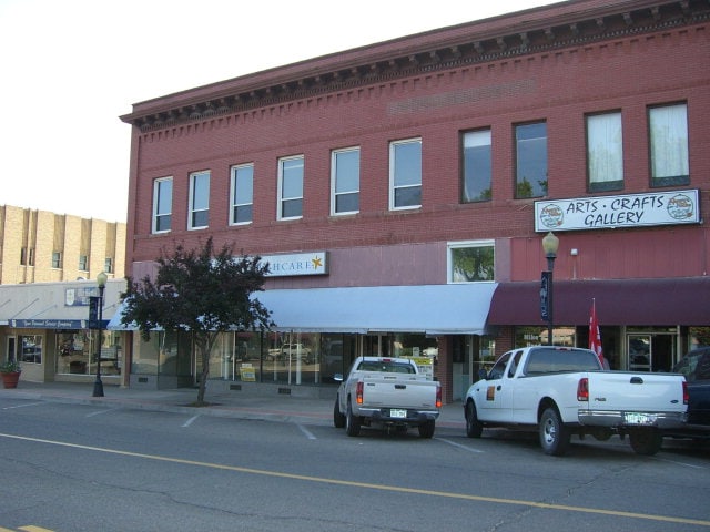
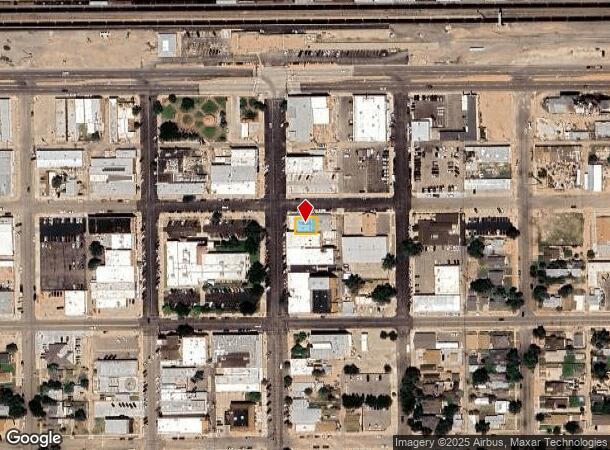
Property Record
201 Colorado Ave, La Junta, CO 81050
NEARBY LISTINGS FOR SALE OR LEASE
Property Detail
201 Colorado Ave
4643-023-12015
LOTS 23 & 24 BLK 25 LJ EX THE E 74.53' OF SAID LOTS; B993 P113 B1055 P312-315 B1057 P483 #602665; MS#459 REL SCH107689,113126
Storebuilding
Otero
2024
Colorado
2024
0.08 AC
968600
Colorado East Area
2,960 SF
Other Market Areas
DEMOGRAPHICS near 201 Colorado Ave
1 Mile
3 Mile
5 Mile
2024 Total Population
5,376
8,447
9,018
2029 Population
5,277
8,273
8,829
Pop Growth 2024-2029
(1.84%)
(2.06%)
(2.10%)
Average Age
39
40
40
2024 Total Households
2,198
3,466
3,691
HH Growth 2024-2029
(1.96%)
(2.11%)
(2.14%)
Median Household Inc
$47,111
$50,668
$51,092
Avg Household Size
2.30
2.30
2.30
2024 Avg HH Vehicles
2.00
2.00
2.00
Median Home Value
$89,232
$119,877
$124,812
Median Year Built
1952
1964
1964
Nearby Places
- Restaurants
- Banks
- Shops
- Fitness
- Groceries
PUBLIC TRANSPORTATION
COMMUTER RAIL
La Junta Amtrak Station (Southwest Chief - Amtrak)
DRIVE
WALK
Distance
La Junta Amtrak Station (Southwest Chief - Amtrak)
0 min
2 min
0.1 mi
Freight Ports
Tulsa Port Of Catoosa
DRIVE
WALK
Distance
Tulsa Port Of Catoosa
677 min
553.1 mi
SALE & LEASE HISTORY
LISTING DATE
SALE/LEASE

Sep 24, 2016
For Sale
Dec 01, 2017
For Sale
Nearby Properties
Address
Land Use
TOTAL SIZE
Lot Size
Zoning
Address
Land Use
TOTAL SIZE
Lot Size
Zoning
17,669 SF
6.64 AC
Address
Land Use
TOTAL SIZE
Lot Size
Zoning
143,342 SF
18.40 AC
Address
Land Use
TOTAL SIZE
Lot Size
Zoning
31,827 SF
2.13 AC
Address
Land Use
TOTAL SIZE
Lot Size
Zoning
5,225 SF
2.07 AC
Address
Land Use
TOTAL SIZE
Lot Size
Zoning
43,000 SF
28.30 AC
Address
Land Use
TOTAL SIZE
Lot Size
Zoning
91,625 SF
Address
Land Use
TOTAL SIZE
Lot Size
Zoning
69,087 SF
8.28 AC
Address
Land Use
TOTAL SIZE
Lot Size
Zoning
40,238 SF
1.86 AC
Address
Land Use
TOTAL SIZE
Lot Size
Zoning
24,228 SF
3.10 AC
Address
Land Use
TOTAL SIZE
Lot Size
Zoning
38,891 SF
7.60 AC
Address
Land Use
TOTAL SIZE
Lot Size
Zoning
32,615 SF
1.75 AC
Address
Land Use
TOTAL SIZE
Lot Size
Zoning
23,034 SF
35 AC
Address
Land Use
TOTAL SIZE
Lot Size
Zoning
32,742 SF
3.37 AC
Address
Land Use
TOTAL SIZE
Lot Size
Zoning
37,830 SF
0.79 AC
Address
Land Use
TOTAL SIZE
Lot Size
Zoning
19,380 SF
2.90 AC
Address
Land Use
TOTAL SIZE
Lot Size
Zoning
28,194 SF
2.42 AC
Address
Land Use
TOTAL SIZE
Lot Size
Zoning
64,848 SF
4.58 AC
Address
Land Use
TOTAL SIZE
Lot Size
Zoning
14,034 SF
2.02 AC
Address
Land Use
TOTAL SIZE
Lot Size
Zoning
22,700 SF
2.82 AC
Address
Land Use
TOTAL SIZE
Lot Size
Zoning
24,805 SF
3.85 AC
Address
Land Use
TOTAL SIZE
Lot Size
Zoning
12,000 SF
1.14 AC
Address
Land Use
TOTAL SIZE
Lot Size
Zoning
12,500 SF
13.20 AC
Address
Land Use
TOTAL SIZE
Lot Size
Zoning
92,124 SF
Address
Land Use
TOTAL SIZE
Lot Size
Zoning
30,150 SF
Address
Land Use
TOTAL SIZE
Lot Size
Zoning
10,834 SF
2.01 AC
Address
Land Use
TOTAL SIZE
Lot Size
Zoning
18,547 SF
0.96 AC
Address
Land Use
TOTAL SIZE
Lot Size
Zoning
5,280 SF
0.95 AC
Address
Land Use
TOTAL SIZE
Lot Size
Zoning
34,203 SF
2.07 AC
Address
Land Use
TOTAL SIZE
Lot Size
Zoning
16,881 SF
1.17 AC
Address
Land Use
TOTAL SIZE
Lot Size
Zoning
11,460 SF
0.68 AC
The World's #1 Commercial Real Estate Marketplace
Connect with us
© 2025 CoStar Group
The information above has been obtained from sources believed reliable. While we do not doubt its accuracy we have not verified it and make no guarantee, warranty or representation about it. It is your responsibility to independently confirm its accuracy and completeness. Any projections, opinions, assumptions, or estimates used are for example only and do not represent the current or future performance of the property. The value of this transaction to you depends on tax and other factors which should be evaluated by your tax, financial, and legal advisors. You and your advisors should conduct a careful, independent investigation of the property to determine to your satisfaction the suitability of the property for your needs.