Property Record
201 45Th Ave Ne, Minot, ND 58703

NEARBY LISTINGS FOR SALE OR LEASE
Property Detail
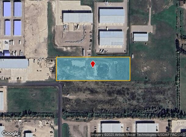
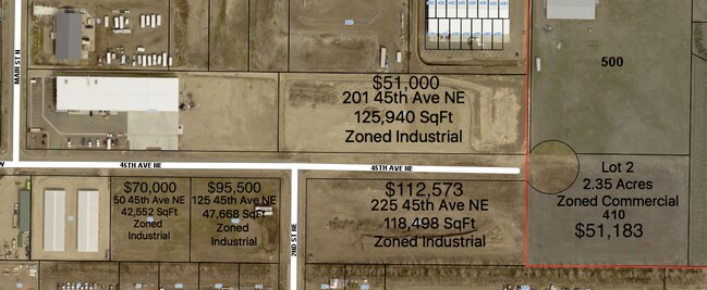
201 45Th Ave Ne
Other Market Areas
Ridgedale Industrial Park
Minot, ND
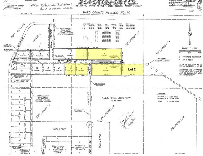
SUB: MI01819 RIDGEDALE INDUSTRIAL PARK LOT 4
MI-01819-000-004-0
Ward
Commercialacreage
North Dakota
2024
4
2024
2.89 AC
010302
Northeast Minot
DEMOGRAPHICS near 201 45Th Ave Ne
1 Mile
3 Mile
5 Mile
2024 Total Population
2,021
18,251
40,724
2029 Population
1,990
17,988
40,146
Pop Growth 2024-2029
(1.53%)
(1.44%)
(1.42%)
Average Age
32
35
37
2024 Total Households
904
7,671
17,251
HH Growth 2024-2029
(1.66%)
(1.63%)
(1.49%)
Median Household Inc
$70,089
$70,961
$69,164
Avg Household Size
2.20
2.20
2.20
2024 Avg HH Vehicles
2.00
2.00
2.00
Median Home Value
$264,912
$226,478
$233,021
Median Year Built
2006
1982
1977
Nearby Places
Map Layers
Map Styles
 Street
 Aerial
- Restaurants
- Banks
- Shops
- Fitness
- Groceries
PUBLIC TRANSPORTATION
COMMUTER RAIL
Minot Amtrak Station (Empire Builder - Amtrak)
DRIVE
WALK
Distance
Minot Amtrak Station (Empire Builder - Amtrak)
7 min
3.8 mi
AIRPORT
Minot International
DRIVE
WALK
Distance
Minot International
7 min
3.2 mi
Freight Ports
Port Milwaukee
DRIVE
WALK
Distance
Port Milwaukee
949 min
875.1 mi
SALE & LEASE HISTORY
LISTING DATE
SALE/LEASE

Dec 21, 2018
For Sale
Aug 22, 2017
For Sale
Nearby Properties
Address
Land Use
TOTAL SIZE
Lot Size
Zoning
Address
Land Use
TOTAL SIZE
Lot Size
Zoning
121,307 SF
2.97 AC
Address
Land Use
TOTAL SIZE
Lot Size
Zoning
46,496 SF
2.41 AC
Address
Land Use
TOTAL SIZE
Lot Size
Zoning
47,150 SF
6.43 AC
Address
Land Use
TOTAL SIZE
Lot Size
Zoning
30,000 SF
8.53 AC
Address
Land Use
TOTAL SIZE
Lot Size
Zoning
31,924 SF
2.82 AC
Address
Land Use
TOTAL SIZE
Lot Size
Zoning
6,120 SF
0.53 AC
Address
Land Use
TOTAL SIZE
Lot Size
Zoning
6,930 SF
0.51 AC
Address
Land Use
TOTAL SIZE
Lot Size
Zoning
15,000 SF
4.57 AC
Address
Land Use
TOTAL SIZE
Lot Size
Zoning
9,900 SF
1.39 AC
Address
Land Use
TOTAL SIZE
Lot Size
Zoning
4,244 SF
0.60 AC
Address
Land Use
TOTAL SIZE
Lot Size
Zoning
20,818 SF
1.80 AC
Address
Land Use
TOTAL SIZE
Lot Size
Zoning
13.84 AC
Address
Land Use
TOTAL SIZE
Lot Size
Zoning
12.79 AC
Address
Land Use
TOTAL SIZE
Lot Size
Zoning
1.51 AC
Address
Land Use
TOTAL SIZE
Lot Size
Zoning
6,000 SF
3.17 AC
Address
Land Use
TOTAL SIZE
Lot Size
Zoning
51.50 AC
Address
Land Use
TOTAL SIZE
Lot Size
Zoning
2,468 SF
0.54 AC
Address
Land Use
TOTAL SIZE
Lot Size
Zoning
6,316 SF
0.82 AC
Address
Land Use
TOTAL SIZE
Lot Size
Zoning
19,947 SF
0.81 AC
Address
Land Use
TOTAL SIZE
Lot Size
Zoning
1.16 AC
Address
Land Use
TOTAL SIZE
Lot Size
Zoning
8.28 AC
Address
Land Use
TOTAL SIZE
Lot Size
Zoning
5,705 SF
1.24 AC
Address
Land Use
TOTAL SIZE
Lot Size
Zoning
8.02 AC
Address
Land Use
TOTAL SIZE
Lot Size
Zoning
3.72 AC
Address
Land Use
TOTAL SIZE
Lot Size
Zoning
5,169 SF
1.21 AC
The World's #1 Commercial Real Estate Marketplace
Connect with us
© 2026 CoStar Group
The information above has been obtained from sources believed reliable. While we do not doubt its accuracy we have not verified it and make no guarantee, warranty or representation about it. It is your responsibility to independently confirm its accuracy and completeness. Any projections, opinions, assumptions, or estimates used are for example only and do not represent the current or future performance of the property. The value of this transaction to you depends on tax and other factors which should be evaluated by your tax, financial, and legal advisors. You and your advisors should conduct a careful, independent investigation of the property to determine to your satisfaction the suitability of the property for your needs.