Property Record
201 Amity Rd, Woodbridge, CT 06525


Save to a Folder
{{folder.Name}}
{{folder.ListingIds.length}} Properties
{{folder.ListingIds.length}} Property
Create a New Folder
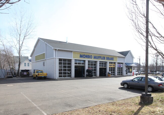
Property Detail
201 Amity Rd
WOOD-002701-000030-000201
South Central Ct
Autorepair
Connecticut
BI
201
B and X Area of moderate flood hazard, usually the area between the limits of the 100-year and 500-year floods.
0.86 AC
2025
Woodbridge
2025
Westchester/So Connecticut
160200
New Haven, CT
4,500 SF
NEARBY LISTINGS FOR SALE OR LEASE
DEMOGRAPHICS near 201 Amity Rd
1 mile
3 mile
5 mile
2025 Total Population
6,941
69,331
212,124
2030 Population
7,056
69,521
214,084
Pop Growth 2025-2030
+ 1.66%
+ 0.27%
+ 0.92%
Average Age
40
38
38
2025 Total Households
2,714
25,480
82,005
HH Growth 2025-2030
+ 1.73%
+ 0.09%
+ 1.03%
Median Household Inc
$72,508
$67,432
$69,428
Avg Household Size
2.50
2.50
2.30
2025 Avg HH Vehicles
2.00
1.00
1.00
Median Home Value
$280,625
$305,826
$318,299
Median Year Built
1956
1951
1956
Nearby Places
Map Layers
Map Styles
 Street
 Aerial
Layers
 Traffic
 Biking
Places
Listings with unknown addresses are not visible on the map
- Restaurants
- Banks
- Shops
- Fitness
- Groceries
PUBLIC TRANSPORTATION
COMMUTER RAIL
New Haven-State Street Station (New Haven Line - Metro-North Commuter Railroad Company (Metro-North))
Drive
Walk
Distance
New Haven-State Street Station (New Haven Line - Metro-North Commuter Railroad Company (Metro-North))
8 min
4.3 mi
Drive
Walk
Distance
9 min
4.9 mi
AIRPORT
Tweed/New Haven
Drive
Walk
Distance
Tweed/New Haven
19 min
8.5 mi
Freight Ports
Port of New Haven
Drive
Walk
Distance
Port of New Haven
13 min
6.4 mi
Nearby Properties
Address
Land Use
TOTAL SIZE
Lot Size
Zoning
Address
Land Use
TOTAL SIZE
Lot Size
Zoning
302,262 SF
10.40 AC
RM1
Address
Land Use
TOTAL SIZE
Lot Size
Zoning
8,758 SF
12.74 AC
IH
Address
Land Use
TOTAL SIZE
Lot Size
Zoning
111,274 SF
22.62 AC
CEM
Address
Land Use
TOTAL SIZE
Lot Size
Zoning
9,767 SF
33.63 AC
RM1
Address
Land Use
TOTAL SIZE
Lot Size
Zoning
316,781 SF
9.20 AC
PDU 94
Address
Land Use
TOTAL SIZE
Lot Size
Zoning
57,339 SF
3.46 AC
RM2
Address
Land Use
TOTAL SIZE
Lot Size
Zoning
75,139 SF
3.54 AC
RM1
Address
Land Use
TOTAL SIZE
Lot Size
Zoning
6,784 SF
17.53 AC
RM1
Address
Land Use
TOTAL SIZE
Lot Size
Zoning
73,504 SF
7.97 AC
PDD 10
Address
Land Use
TOTAL SIZE
Lot Size
Zoning
43,673 SF
4.84 AC
RM2
Address
Land Use
TOTAL SIZE
Lot Size
Zoning
34,373 SF
4.57 AC
RM2
Address
Land Use
TOTAL SIZE
Lot Size
Zoning
78,579 SF
6.07 AC
RM2
Address
Land Use
TOTAL SIZE
Lot Size
Zoning
25 AC
A
Address
Land Use
TOTAL SIZE
Lot Size
Zoning
576 SF
RS2
Address
Land Use
TOTAL SIZE
Lot Size
Zoning
4,334 SF
70 AC
PARK
Address
Land Use
TOTAL SIZE
Lot Size
Zoning
119,187 SF
1.38 AC
RO
Address
Land Use
TOTAL SIZE
Lot Size
Zoning
92,126 SF
4.32 AC
RM2
Address
Land Use
TOTAL SIZE
Lot Size
Zoning
46,962 SF
1.48 AC
RM1/RS
Address
Land Use
TOTAL SIZE
Lot Size
Zoning
86,644 SF
14 AC
PARK
Address
Land Use
TOTAL SIZE
Lot Size
Zoning
140,931 SF
1.86 AC
RM2
Address
Land Use
TOTAL SIZE
Lot Size
Zoning
59,950 SF
3.29 AC
R4
Address
Land Use
TOTAL SIZE
Lot Size
Zoning
90,740 SF
1.97 AC
BA/RM1
Address
Land Use
TOTAL SIZE
Lot Size
Zoning
10.43 AC
M
Address
Land Use
TOTAL SIZE
Lot Size
Zoning
154,023 SF
1.79 AC
PDD
Address
Land Use
TOTAL SIZE
Lot Size
Zoning
93,849 SF
3.16 AC
RM1
Address
Land Use
TOTAL SIZE
Lot Size
Zoning
89,436 SF
14.41 AC
R2
Address
Land Use
TOTAL SIZE
Lot Size
Zoning
13,204 SF
PDD 86
Address
Land Use
TOTAL SIZE
Lot Size
Zoning
146,678 SF
43.44 AC
A
Address
Land Use
TOTAL SIZE
Lot Size
Zoning
483,360 SF
3.11 AC
PDD 49
Address
Land Use
TOTAL SIZE
Lot Size
Zoning
92,221 SF
3.90 AC
RM2
The World's #1 Commercial Real Estate Marketplace
Connect with us
© 2026 CoStar Group
The information above has been obtained from sources believed reliable. While we do not doubt its accuracy we have not verified it and make no guarantee, warranty or representation about it. It is your responsibility to independently confirm its accuracy and completeness. Any projections, opinions, assumptions, or estimates used are for example only and do not represent the current or future performance of the property. The value of this transaction to you depends on tax and other factors which should be evaluated by your tax, financial, and legal advisors. You and your advisors should conduct a careful, independent investigation of the property to determine to your satisfaction the suitability of the property for your needs.