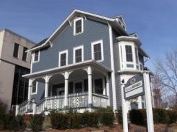
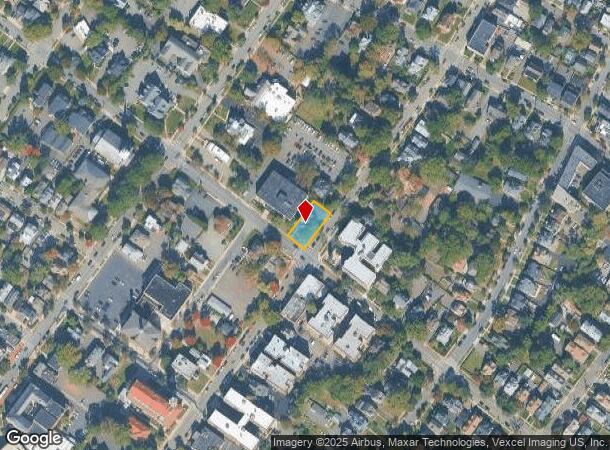
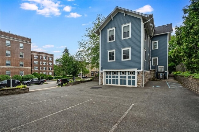
Property Record
201 Claremont Ave, Montclair, NJ 07042
NEARBY LISTINGS FOR SALE OR LEASE
Property Detail
201 Claremont Ave
13-02311-0000-00013
60X129 IRR
Commercialnec
Essex
X
New Jersey
34013C0104G
13
2023
0.18 AC
2025
Urban Essex
016600
Northern New Jersey
2,314 SF
Newark, NJ-PA
DEMOGRAPHICS near 201 Claremont Ave
1 Mile
3 Mile
5 Mile
2024 Total Population
24,579
194,711
594,012
2029 Population
24,298
191,539
581,789
Pop Growth 2024-2029
(1.14%)
(1.63%)
(2.06%)
Average Age
40
41
40
2024 Total Households
10,311
74,440
221,442
HH Growth 2024-2029
(1.28%)
(1.80%)
(2.17%)
Median Household Inc
$125,410
$99,547
$80,015
Avg Household Size
2.30
2.50
2.60
2024 Avg HH Vehicles
1.00
2.00
2.00
Median Home Value
$681,737
$471,656
$448,812
Median Year Built
1948
1952
1955
Nearby Places
Map Layers
Map Styles
 Street
 Aerial
- Restaurants
- Banks
- Shops
- Fitness
- Groceries
PUBLIC TRANSPORTATION
TRANSIT/SUBWAY
Walnut Street (Montclair-Boonton Line - NJ Transit Commuter Rail (NJ Transit))
DRIVE
WALK
Distance
Walnut Street (Montclair-Boonton Line - NJ Transit Commuter Rail (NJ Transit))
2 min
8 min
0.4 mi
Bay Street (Montclair-Boonton Line - NJ Transit Commuter Rail (NJ Transit))
DRIVE
WALK
Distance
Bay Street (Montclair-Boonton Line - NJ Transit Commuter Rail (NJ Transit))
3 min
17 min
0.9 mi
COMMUTER RAIL
Walnut Street (Montclair-Boonton Line - NJ Transit Commuter Rail (NJ Transit))
DRIVE
WALK
Distance
Walnut Street (Montclair-Boonton Line - NJ Transit Commuter Rail (NJ Transit))
2 min
8 min
0.4 mi
Bay Street (Montclair-Boonton Line - NJ Transit Commuter Rail (NJ Transit))
DRIVE
WALK
Distance
Bay Street (Montclair-Boonton Line - NJ Transit Commuter Rail (NJ Transit))
3 min
17 min
0.9 mi
AIRPORT
Newark Liberty International
DRIVE
WALK
Distance
Newark Liberty International
24 min
13.6 mi
LaGuardia
DRIVE
WALK
Distance
LaGuardia
46 min
25.1 mi
John F Kennedy International
DRIVE
WALK
Distance
John F Kennedy International
56 min
33.2 mi
Freight Ports
Maher Terminal
DRIVE
WALK
Distance
Maher Terminal
29 min
14.7 mi
SALE & LEASE HISTORY
LISTING DATE
SALE/LEASE

Jul 09, 2025
For Sale
Dec 18, 2022
For Lease
Nearby Properties
Address
Land Use
TOTAL SIZE
Lot Size
Zoning
Address
Land Use
TOTAL SIZE
Lot Size
Zoning
33.60 AC
P-C
Address
Land Use
TOTAL SIZE
Lot Size
Zoning
5 AC
H
Address
Land Use
TOTAL SIZE
Lot Size
Zoning
Address
Land Use
TOTAL SIZE
Lot Size
Zoning
16,084 SF
7.23 AC
Address
Land Use
TOTAL SIZE
Lot Size
Zoning
1,589 SF
R4
Address
Land Use
TOTAL SIZE
Lot Size
Zoning
12.54 AC
OPRP
Address
Land Use
TOTAL SIZE
Lot Size
Zoning
Address
Land Use
TOTAL SIZE
Lot Size
Zoning
2.64 AC
Address
Land Use
TOTAL SIZE
Lot Size
Zoning
11.49 AC
M-1
Address
Land Use
TOTAL SIZE
Lot Size
Zoning
31.36 AC
P-6
Address
Land Use
TOTAL SIZE
Lot Size
Zoning
3.26 AC
PR
Address
Land Use
TOTAL SIZE
Lot Size
Zoning
0.17 AC
BCR1
Address
Land Use
TOTAL SIZE
Lot Size
Zoning
2.22 AC
OB-2
Address
Land Use
TOTAL SIZE
Lot Size
Zoning
1.67 AC
BCR1
Address
Land Use
TOTAL SIZE
Lot Size
Zoning
3.20 AC
BSRD
Address
Land Use
TOTAL SIZE
Lot Size
Zoning
224 SF
0.94 AC
BCR1
Address
Land Use
TOTAL SIZE
Lot Size
Zoning
1.50 AC
RA
Address
Land Use
TOTAL SIZE
Lot Size
Zoning
1.95 AC
RA
Address
Land Use
TOTAL SIZE
Lot Size
Zoning
3.64 AC
R-M
Address
Land Use
TOTAL SIZE
Lot Size
Zoning
9.98 AC
R-1
Address
Land Use
TOTAL SIZE
Lot Size
Zoning
364.34 AC
R-1
Address
Land Use
TOTAL SIZE
Lot Size
Zoning
25.88 AC
Address
Land Use
TOTAL SIZE
Lot Size
Zoning
228,736 SF
48.25 AC
Address
Land Use
TOTAL SIZE
Lot Size
Zoning
17.90 AC
R-G
Address
Land Use
TOTAL SIZE
Lot Size
Zoning
12.52 AC
Address
Land Use
TOTAL SIZE
Lot Size
Zoning
12.08 AC
R-G
Address
Land Use
TOTAL SIZE
Lot Size
Zoning
1,760 SF
189.03 AC
R-2
Address
Land Use
TOTAL SIZE
Lot Size
Zoning
9.38 AC
R-G
Address
Land Use
TOTAL SIZE
Lot Size
Zoning
5.20 AC
R-H
Address
Land Use
TOTAL SIZE
Lot Size
Zoning
5.74 AC
B-2
The World's #1 Commercial Real Estate Marketplace
Connect with us
© 2025 CoStar Group
The information above has been obtained from sources believed reliable. While we do not doubt its accuracy we have not verified it and make no guarantee, warranty or representation about it. It is your responsibility to independently confirm its accuracy and completeness. Any projections, opinions, assumptions, or estimates used are for example only and do not represent the current or future performance of the property. The value of this transaction to you depends on tax and other factors which should be evaluated by your tax, financial, and legal advisors. You and your advisors should conduct a careful, independent investigation of the property to determine to your satisfaction the suitability of the property for your needs.