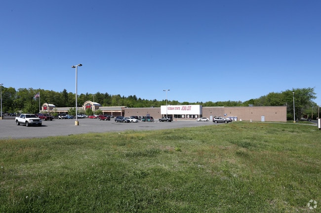
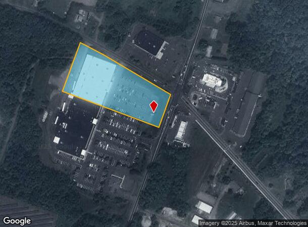
Property Record
201 College Hwy, Southwick, MA 01077

NEARBY LISTINGS FOR SALE OR LEASE
Property Detail
201 College Hwy
SWIC-000140-000000-000013
Hampden
Departmentstore
Massachusetts
X
13
25013C0368E
3.46 AC
2025
Hampden County
2025
Hartford
813102
Springfield, MA
45,840 SF
DEMOGRAPHICS near 201 College Hwy
1 Mile
3 Mile
5 Mile
2024 Total Population
779
9,519
21,650
2029 Population
768
9,425
21,433
Pop Growth 2024-2029
(1.41%)
(0.99%)
(1.00%)
Average Age
43
44
44
2024 Total Households
304
3,865
8,573
HH Growth 2024-2029
(1.32%)
(1.06%)
(1.08%)
Median Household Inc
$105,183
$106,647
$110,314
Avg Household Size
2.50
2.40
2.50
2024 Avg HH Vehicles
3.00
2.00
2.00
Median Home Value
$382,278
$352,904
$343,357
Median Year Built
1984
1975
1975
Nearby Places
Map Layers
Map Styles
 Street
 Aerial
- Restaurants
- Banks
- Shops
- Fitness
- Groceries
PUBLIC TRANSPORTATION
AIRPORT
Bradley International
DRIVE
WALK
Distance
Bradley International
29 min
12.4 mi
Freight Ports
Port of New Haven
DRIVE
WALK
Distance
Port of New Haven
82 min
55.9 mi
Nearby Properties
Address
Land Use
TOTAL SIZE
Lot Size
Zoning
Address
Land Use
TOTAL SIZE
Lot Size
Zoning
4,628 SF
16.01 AC
R-20
Address
Land Use
TOTAL SIZE
Lot Size
Zoning
27,730 SF
17 AC
BR
Address
Land Use
TOTAL SIZE
Lot Size
Zoning
58,477 SF
14.99 AC
R30
Address
Land Use
TOTAL SIZE
Lot Size
Zoning
2,684 SF
17.01 AC
BR
Address
Land Use
TOTAL SIZE
Lot Size
Zoning
57,159 SF
7.07 AC
B
Address
Land Use
TOTAL SIZE
Lot Size
Zoning
10,114 SF
33 AC
BR
Address
Land Use
TOTAL SIZE
Lot Size
Zoning
31,216 SF
9.20 AC
I
Address
Land Use
TOTAL SIZE
Lot Size
Zoning
2,183 SF
5.59 AC
BR
Address
Land Use
TOTAL SIZE
Lot Size
Zoning
5,501 SF
7.70 AC
R-20
Address
Land Use
TOTAL SIZE
Lot Size
Zoning
12.98 AC
I
Address
Land Use
TOTAL SIZE
Lot Size
Zoning
12.98 AC
Address
Land Use
TOTAL SIZE
Lot Size
Zoning
11,304 SF
0.52 AC
BR
Address
Land Use
TOTAL SIZE
Lot Size
Zoning
12,847 SF
2.25 AC
B
Address
Land Use
TOTAL SIZE
Lot Size
Zoning
9,574 SF
5.80 AC
R-40
Address
Land Use
TOTAL SIZE
Lot Size
Zoning
21,200 SF
3 AC
BR
Address
Land Use
TOTAL SIZE
Lot Size
Zoning
1,819 SF
3.45 AC
B
Address
Land Use
TOTAL SIZE
Lot Size
Zoning
10,655 SF
1.43 AC
BR
Address
Land Use
TOTAL SIZE
Lot Size
Zoning
10,900 SF
6.97 AC
NC
Address
Land Use
TOTAL SIZE
Lot Size
Zoning
35,478 SF
3.10 AC
BR
Address
Land Use
TOTAL SIZE
Lot Size
Zoning
9,992 SF
31.41 AC
R-40
Address
Land Use
TOTAL SIZE
Lot Size
Zoning
2.20 AC
NC
Address
Land Use
TOTAL SIZE
Lot Size
Zoning
2.89 AC
R30
Address
Land Use
TOTAL SIZE
Lot Size
Zoning
5.16 AC
I
Address
Land Use
TOTAL SIZE
Lot Size
Zoning
5,568 SF
5.51 AC
R-40
Address
Land Use
TOTAL SIZE
Lot Size
Zoning
3,616 SF
1.70 AC
R-40
Address
Land Use
TOTAL SIZE
Lot Size
Zoning
18,373 SF
2.40 AC
BR
Address
Land Use
TOTAL SIZE
Lot Size
Zoning
4,015 SF
1.11 AC
B
Address
Land Use
TOTAL SIZE
Lot Size
Zoning
10,537 SF
6.40 AC
BR
Address
Land Use
TOTAL SIZE
Lot Size
Zoning
5,000 SF
3.36 AC
I
The World's #1 Commercial Real Estate Marketplace
Connect with us
© 2026 CoStar Group
The information above has been obtained from sources believed reliable. While we do not doubt its accuracy we have not verified it and make no guarantee, warranty or representation about it. It is your responsibility to independently confirm its accuracy and completeness. Any projections, opinions, assumptions, or estimates used are for example only and do not represent the current or future performance of the property. The value of this transaction to you depends on tax and other factors which should be evaluated by your tax, financial, and legal advisors. You and your advisors should conduct a careful, independent investigation of the property to determine to your satisfaction the suitability of the property for your needs.