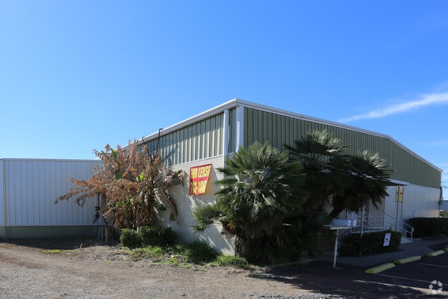
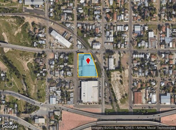
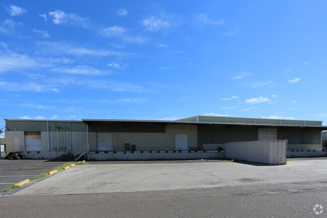
Property Record
201 Corpus Christi St, Laredo, TX 78040
NEARBY LISTINGS FOR SALE OR LEASE
Property Detail
201 Corpus Christi St
167666
Eastern -- Blocks 1 - 50
Commercialnec
71.55% OF ALL 41 ED
X
Webb
48479C1215C
Texas
2024
1
2025
1.27 AC
000200
Other Market Areas
31,009 SF
Laredo, TX
DEMOGRAPHICS near 201 Corpus Christi St
1 Mile
3 Mile
5 Mile
2024 Total Population
17,902
99,837
180,428
2029 Population
18,034
100,188
181,854
Pop Growth 2024-2029
+ 0.74%
+ 0.35%
+ 0.79%
Average Age
37
36
34
2024 Total Households
5,755
31,503
53,712
HH Growth 2024-2029
+ 0.75%
+ 0.42%
+ 0.81%
Median Household Inc
$27,758
$36,336
$45,589
Avg Household Size
3.00
3.10
3.30
2024 Avg HH Vehicles
1.00
2.00
2.00
Median Home Value
$105,119
$113,891
$138,265
Median Year Built
1967
1979
1990
Nearby Places
Map Layers
Map Styles
 Street
 Aerial
- Restaurants
- Banks
- Shops
- Fitness
- Groceries
PUBLIC TRANSPORTATION
AIRPORT
Laredo International
DRIVE
WALK
Distance
Laredo International
12 min
5.8 mi
SALE & LEASE HISTORY
LISTING DATE
SALE/LEASE

Jan 31, 2017
For Lease
Nearby Properties
Address
Land Use
TOTAL SIZE
Lot Size
Zoning
Address
Land Use
TOTAL SIZE
Lot Size
Zoning
1,019,636 SF
202.89 AC
B3
Address
Land Use
TOTAL SIZE
Lot Size
Zoning
668,900 SF
38.32 AC
B4
Address
Land Use
TOTAL SIZE
Lot Size
Zoning
497,463 SF
1.77 AC
R1
Address
Land Use
TOTAL SIZE
Lot Size
Zoning
423,977 SF
1.27 AC
R2
Address
Land Use
TOTAL SIZE
Lot Size
Zoning
224,926 SF
21.49 AC
R3
Address
Land Use
TOTAL SIZE
Lot Size
Zoning
689,547 SF
2.70 AC
B3
Address
Land Use
TOTAL SIZE
Lot Size
Zoning
258,114 SF
30.54 AC
B1
Address
Land Use
TOTAL SIZE
Lot Size
Zoning
231,146 SF
1.77 AC
R1
Address
Land Use
TOTAL SIZE
Lot Size
Zoning
144,491 SF
3.54 AC
CBD
Address
Land Use
TOTAL SIZE
Lot Size
Zoning
380,420 SF
9.18 AC
B3
Address
Land Use
TOTAL SIZE
Lot Size
Zoning
227,503 SF
19.84 AC
B4
Address
Land Use
TOTAL SIZE
Lot Size
Zoning
96,991 SF
1.59 AC
CBD
Address
Land Use
TOTAL SIZE
Lot Size
Zoning
192,176 SF
34.94 AC
Address
Land Use
TOTAL SIZE
Lot Size
Zoning
127,364 SF
1.60 AC
CBD
Address
Land Use
TOTAL SIZE
Lot Size
Zoning
157,376 SF
25.86 AC
B3
Address
Land Use
TOTAL SIZE
Lot Size
Zoning
183,795 SF
10.36 AC
R2
Address
Land Use
TOTAL SIZE
Lot Size
Zoning
25,104 SF
1.42 AC
CBD
Address
Land Use
TOTAL SIZE
Lot Size
Zoning
101,734 SF
1.63 AC
B3
Address
Land Use
TOTAL SIZE
Lot Size
Zoning
66,567 SF
3.81 AC
M1
Address
Land Use
TOTAL SIZE
Lot Size
Zoning
113,687 SF
5.58 AC
R3
Address
Land Use
TOTAL SIZE
Lot Size
Zoning
93,414 SF
8.57 AC
R1
Address
Land Use
TOTAL SIZE
Lot Size
Zoning
102,815 SF
2.23 AC
Address
Land Use
TOTAL SIZE
Lot Size
Zoning
98,005 SF
0.67 AC
B3
Address
Land Use
TOTAL SIZE
Lot Size
Zoning
70,980 SF
1.44 AC
CBD
Address
Land Use
TOTAL SIZE
Lot Size
Zoning
97,580 SF
3.89 AC
B1
Address
Land Use
TOTAL SIZE
Lot Size
Zoning
79,764 SF
30 AC
R1
Address
Land Use
TOTAL SIZE
Lot Size
Zoning
94,056 SF
1.77 AC
Address
Land Use
TOTAL SIZE
Lot Size
Zoning
92,559 SF
5.70 AC
R1
Address
Land Use
TOTAL SIZE
Lot Size
Zoning
98,475 SF
1.59 AC
R3
Address
Land Use
TOTAL SIZE
Lot Size
Zoning
72,087 SF
3.91 AC
M1
The World's #1 Commercial Real Estate Marketplace
Connect with us
© 2026 CoStar Group
The information above has been obtained from sources believed reliable. While we do not doubt its accuracy we have not verified it and make no guarantee, warranty or representation about it. It is your responsibility to independently confirm its accuracy and completeness. Any projections, opinions, assumptions, or estimates used are for example only and do not represent the current or future performance of the property. The value of this transaction to you depends on tax and other factors which should be evaluated by your tax, financial, and legal advisors. You and your advisors should conduct a careful, independent investigation of the property to determine to your satisfaction the suitability of the property for your needs.