Property Record
201 County Road 137, Hutto, TX 78634
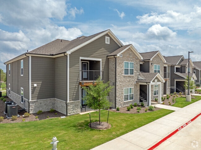


Property Detail
201 County Road 137
Austin-Round Rock-San Marcos, TX
S12971 - CARVER RIDGE APARTMENTS PH 1 (BLK 1 LOT 1), BLOCK 1, LOT 1, ACRES 7.529
R631712
WILLIAMSON
Multifamilydwelling
Texas
2024
1
2025
7.53 AC
020819
Far Northeast
83,307 SF
Austin
NEARBY LISTINGS FOR SALE OR LEASE
-
-
View all Hutto listings for sale on LoopNet.com
DEMOGRAPHICS near 201 County Road 137
1 mile
3 mile
5 mile
2025 Total Population
6,884
45,930
116,772
2030 Population
7,929
52,305
130,782
Pop Growth 2025-2030
+ 15.18%
+ 13.88%
+ 12.00%
Average Age
35
36
36
2025 Total Households
2,220
15,329
37,774
HH Growth 2025-2030
+ 15.77%
+ 14.48%
+ 12.56%
Median Household Inc
$118,394
$121,657
$134,813
Avg Household Size
3.10
3.00
3.00
2025 Avg HH Vehicles
2.00
2.00
2.00
Median Home Value
$371,296
$410,018
$455,026
Median Year Built
2008
2010
2010
Nearby Places
Map Layers
Map Styles
 Street
 Aerial
Transit
 Traffic
 Biking
Places
Listings with unknown addresses are not visible on the map
- Restaurants
- Banks
- Shops
- Fitness
- Groceries
PUBLIC TRANSPORTATION
AIRPORT
Austin-Bergstrom International
Drive
Walk
Distance
Austin-Bergstrom International
45 min
33.9 mi
Freight Ports
Calhoun Port
Drive
Walk
Distance
Calhoun Port
205 min
176.8 mi
Nearby Properties
Address
Land Use
TOTAL SIZE
Lot Size
Zoning
Address
Land Use
TOTAL SIZE
Lot Size
Zoning
425,891 SF
20.85 AC
Address
Land Use
TOTAL SIZE
Lot Size
Zoning
409,416 SF
22.65 AC
Address
Land Use
TOTAL SIZE
Lot Size
Zoning
243,097 SF
15.73 AC
Address
Land Use
TOTAL SIZE
Lot Size
Zoning
336,672 SF
15.09 AC
Address
Land Use
TOTAL SIZE
Lot Size
Zoning
302,465 SF
15.79 AC
Address
Land Use
TOTAL SIZE
Lot Size
Zoning
253,225 SF
12.25 AC
Address
Land Use
TOTAL SIZE
Lot Size
Zoning
301,721 SF
16.54 AC
Address
Land Use
TOTAL SIZE
Lot Size
Zoning
304,814 SF
17.04 AC
Address
Land Use
TOTAL SIZE
Lot Size
Zoning
308,759 SF
13.93 AC
Address
Land Use
TOTAL SIZE
Lot Size
Zoning
165,534 SF
26.91 AC
Address
Land Use
TOTAL SIZE
Lot Size
Zoning
76.14 AC
Address
Land Use
TOTAL SIZE
Lot Size
Zoning
230,841 SF
17.51 AC
Address
Land Use
TOTAL SIZE
Lot Size
Zoning
183,310 SF
10.78 AC
Address
Land Use
TOTAL SIZE
Lot Size
Zoning
338,229 SF
15.38 AC
Address
Land Use
TOTAL SIZE
Lot Size
Zoning
243,097 SF
12.53 AC
Address
Land Use
TOTAL SIZE
Lot Size
Zoning
154,528 SF
7.23 AC
Address
Land Use
TOTAL SIZE
Lot Size
Zoning
220,850 SF
12.06 AC
Address
Land Use
TOTAL SIZE
Lot Size
Zoning
161,190 SF
8.82 AC
Address
Land Use
TOTAL SIZE
Lot Size
Zoning
297,577 SF
28.22 AC
Address
Land Use
TOTAL SIZE
Lot Size
Zoning
535,408 SF
30.16 AC
Address
Land Use
TOTAL SIZE
Lot Size
Zoning
147,230 SF
8.05 AC
Address
Land Use
TOTAL SIZE
Lot Size
Zoning
109,908 SF
7.94 AC
Address
Land Use
TOTAL SIZE
Lot Size
Zoning
16.70 AC
Address
Land Use
TOTAL SIZE
Lot Size
Zoning
14.30 AC
Address
Land Use
TOTAL SIZE
Lot Size
Zoning
83,457 SF
6.99 AC
Address
Land Use
TOTAL SIZE
Lot Size
Zoning
309,652 SF
29.26 AC
Address
Land Use
TOTAL SIZE
Lot Size
Zoning
169,068 SF
2.35 AC
Address
Land Use
TOTAL SIZE
Lot Size
Zoning
108,422 SF
15.72 AC
Address
Land Use
TOTAL SIZE
Lot Size
Zoning
51,335 SF
13.77 AC
Address
Land Use
TOTAL SIZE
Lot Size
Zoning
35,187 SF
5.57 AC
The World's #1 Commercial Real Estate Marketplace
Connect with us
© 2026 CoStar Group
The information above has been obtained from sources believed reliable. While we do not doubt its accuracy we have not verified it and make no guarantee, warranty or representation about it. It is your responsibility to independently confirm its accuracy and completeness. Any projections, opinions, assumptions, or estimates used are for example only and do not represent the current or future performance of the property. The value of this transaction to you depends on tax and other factors which should be evaluated by your tax, financial, and legal advisors. You and your advisors should conduct a careful, independent investigation of the property to determine to your satisfaction the suitability of the property for your needs.