Property Record
201 County Road 140, Georgetown, TX 78626

Save to a Folder
{{folder.Name}}
{{folder.ListingIds.length}} Properties
{{folder.ListingIds.length}} Property
Create a New Folder
Property Detail
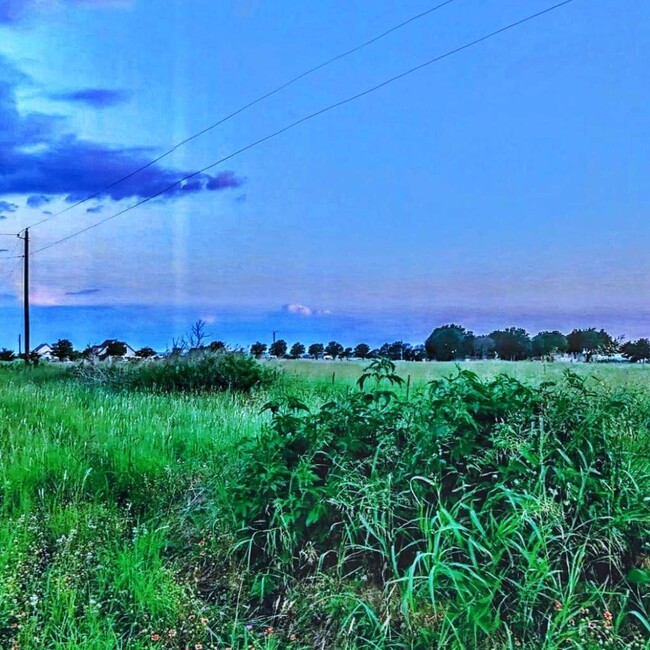
201 County Road 140
Austin-Round Rock-San Marcos, TX
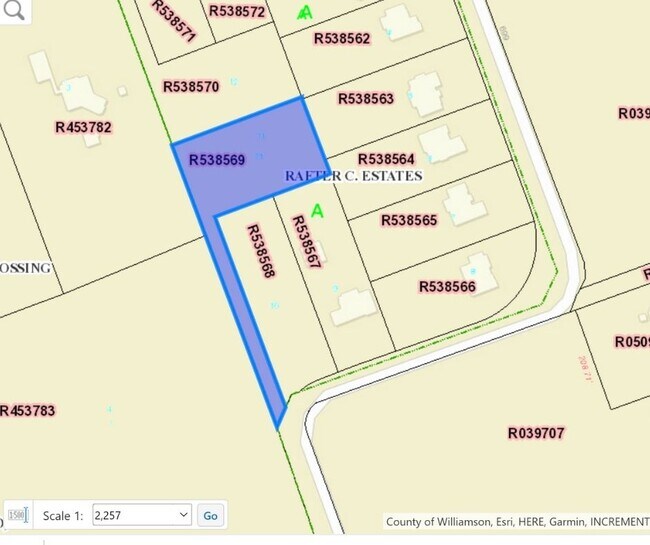
AW0063 AW0063 - BERRY, JOSEPH SUR., ACRES 82.03
R039114
WILLIAMSON
Agriculturalland
Texas
A Areas with a 1% annual chance of flooding and a 26% chance of flooding over the life of a 30-year mortgage.
82.03 AC
2024
Georgetown
2025
Austin
021602
NEARBY LISTINGS FOR SALE OR LEASE
DEMOGRAPHICS near 201 County Road 140
1 mile
3 mile
5 mile
2025 Total Population
171
5,247
36,925
2030 Population
188
6,040
42,498
Pop Growth 2025-2030
+ 9.94%
+ 15.11%
+ 15.09%
Average Age
38
38
39
2025 Total Households
56
1,871
13,415
HH Growth 2025-2030
+ 10.71%
+ 15.77%
+ 15.71%
Median Household Inc
$91,666
$93,878
$96,641
Avg Household Size
3.00
2.70
2.60
2025 Avg HH Vehicles
2.00
2.00
2.00
Median Home Value
$558,823
$352,427
$417,336
Median Year Built
1980
2002
2002
Nearby Places
Map Layers
Map Styles
 Street
 Aerial
Layers
 Traffic
 Biking
Places
Listings with unknown addresses are not visible on the map
- Restaurants
- Banks
- Shops
- Fitness
- Groceries
PUBLIC TRANSPORTATION
AIRPORT
Killeen Municipal
Drive
Walk
Distance
Killeen Municipal
56 min
39.1 mi
Robert Gray AAF
Drive
Walk
Distance
Robert Gray AAF
61 min
43.5 mi
Freight Ports
Calhoun Port
Drive
Walk
Distance
Calhoun Port
213 min
187.3 mi
SALE & LEASE HISTORY
LISTING DATE
SALE/LEASE

Jul 27, 2021
For Sale
Nearby Properties
Address
Land Use
TOTAL SIZE
Lot Size
Zoning
Address
Land Use
TOTAL SIZE
Lot Size
Zoning
520,121 SF
56.73 AC
Address
Land Use
TOTAL SIZE
Lot Size
Zoning
193,985 SF
38.17 AC
Address
Land Use
TOTAL SIZE
Lot Size
Zoning
298,302 SF
20.96 AC
Address
Land Use
TOTAL SIZE
Lot Size
Zoning
232,368 SF
16.40 AC
Address
Land Use
TOTAL SIZE
Lot Size
Zoning
184,242 SF
11 AC
Address
Land Use
TOTAL SIZE
Lot Size
Zoning
131.22 AC
Address
Land Use
TOTAL SIZE
Lot Size
Zoning
99,532 SF
10.80 AC
2-I
Address
Land Use
TOTAL SIZE
Lot Size
Zoning
87,071 SF
60.32 AC
Address
Land Use
TOTAL SIZE
Lot Size
Zoning
182,592 SF
11.20 AC
Address
Land Use
TOTAL SIZE
Lot Size
Zoning
2,400 SF
56.17 AC
Address
Land Use
TOTAL SIZE
Lot Size
Zoning
22,936 SF
111.18 AC
Address
Land Use
TOTAL SIZE
Lot Size
Zoning
39.97 AC
Address
Land Use
TOTAL SIZE
Lot Size
Zoning
98,099 SF
5.13 AC
Address
Land Use
TOTAL SIZE
Lot Size
Zoning
76,433 SF
4.50 AC
Address
Land Use
TOTAL SIZE
Lot Size
Zoning
82,484 SF
7.32 AC
Address
Land Use
TOTAL SIZE
Lot Size
Zoning
11,200 SF
63.89 AC
Address
Land Use
TOTAL SIZE
Lot Size
Zoning
130.98 AC
Address
Land Use
TOTAL SIZE
Lot Size
Zoning
34,780 SF
9.79 AC
Address
Land Use
TOTAL SIZE
Lot Size
Zoning
25,376 SF
11.03 AC
Address
Land Use
TOTAL SIZE
Lot Size
Zoning
36,000 SF
2.46 AC
Address
Land Use
TOTAL SIZE
Lot Size
Zoning
864 SF
33.25 AC
Address
Land Use
TOTAL SIZE
Lot Size
Zoning
19,292 SF
8.32 AC
Address
Land Use
TOTAL SIZE
Lot Size
Zoning
35.03 AC
Address
Land Use
TOTAL SIZE
Lot Size
Zoning
4,710 SF
5.12 AC
Address
Land Use
TOTAL SIZE
Lot Size
Zoning
22,041 SF
4.14 AC
Address
Land Use
TOTAL SIZE
Lot Size
Zoning
27,708 SF
3.53 AC
Address
Land Use
TOTAL SIZE
Lot Size
Zoning
164,046 SF
49.31 AC
Address
Land Use
TOTAL SIZE
Lot Size
Zoning
Address
Land Use
TOTAL SIZE
Lot Size
Zoning
56.07 AC
Address
Land Use
TOTAL SIZE
Lot Size
Zoning
25.84 AC
The World's #1 Commercial Real Estate Marketplace
Connect with us
© 2026 CoStar Group
The information above has been obtained from sources believed reliable. While we do not doubt its accuracy we have not verified it and make no guarantee, warranty or representation about it. It is your responsibility to independently confirm its accuracy and completeness. Any projections, opinions, assumptions, or estimates used are for example only and do not represent the current or future performance of the property. The value of this transaction to you depends on tax and other factors which should be evaluated by your tax, financial, and legal advisors. You and your advisors should conduct a careful, independent investigation of the property to determine to your satisfaction the suitability of the property for your needs.