Property Record
201 E Ashland St, Morton, IL 61550


Save to a Folder
{{folder.Name}}
{{folder.ListingIds.length}} Properties
{{folder.ListingIds.length}} Property
Create a New Folder
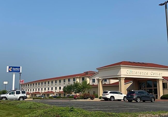
Property Detail
201 E Ashland St
Peoria, IL
SEC 16 T25N R3W MORTON COMMERCE PARK III-FINAL PLAT LOT 3 NW 1/4 SEC 16 & WELKS 1ST ADD IN SE COR NE 1/4 NE 1/4 SEC 17 5.55 AC
06-06-16-100-040
TAZEWELL
Storebuilding
Illinois
B and X Area of moderate flood hazard, usually the area between the limits of the 100-year and 500-year floods.
3
2023
5.55 AC
2024
Outlying Tazewell County
021603
Peoria
75,838 SF
NEARBY LISTINGS FOR SALE OR LEASE
-
-
View all Morton listings for sale on LoopNet.com
DEMOGRAPHICS near 201 E Ashland St
1 mile
3 mile
5 mile
2025 Total Population
3,080
19,410
29,514
2030 Population
3,035
19,309
29,336
Pop Growth 2025-2030
(1.46%)
(0.52%)
(0.60%)
Average Age
40
42
42
2025 Total Households
1,300
7,780
12,094
HH Growth 2025-2030
(1.69%)
(0.71%)
(0.73%)
Median Household Inc
$88,734
$91,212
$83,946
Avg Household Size
2.30
2.40
2.40
2025 Avg HH Vehicles
2.00
2.00
2.00
Median Home Value
$224,193
$238,294
$199,167
Median Year Built
1964
1974
1971
Nearby Places
Map Layers
Map Styles
 Street
 Aerial
Layers
 Traffic
 Biking
Places
Listings with unknown addresses are not visible on the map
- Restaurants
- Banks
- Shops
- Fitness
- Groceries
PUBLIC TRANSPORTATION
AIRPORT
General Downing - Peoria International
Drive
Walk
Distance
General Downing - Peoria International
22 min
15.0 mi
Freight Ports
Port Milwaukee
Drive
Walk
Distance
Port Milwaukee
268 min
229.8 mi
Nearby Properties
Address
Land Use
TOTAL SIZE
Lot Size
Zoning
Address
Land Use
TOTAL SIZE
Lot Size
Zoning
61.31 AC
Address
Land Use
TOTAL SIZE
Lot Size
Zoning
240,900 SF
117.64 AC
Address
Land Use
TOTAL SIZE
Lot Size
Zoning
39,328 SF
5.60 AC
Address
Land Use
TOTAL SIZE
Lot Size
Zoning
95,880 SF
5.38 AC
Address
Land Use
TOTAL SIZE
Lot Size
Zoning
7.81 AC
Address
Land Use
TOTAL SIZE
Lot Size
Zoning
81,129 SF
12.05 AC
Address
Land Use
TOTAL SIZE
Lot Size
Zoning
156,812 SF
20.54 AC
Address
Land Use
TOTAL SIZE
Lot Size
Zoning
122,084 SF
8.12 AC
Address
Land Use
TOTAL SIZE
Lot Size
Zoning
117,138 SF
24.53 AC
Address
Land Use
TOTAL SIZE
Lot Size
Zoning
110,434 SF
11.67 AC
Address
Land Use
TOTAL SIZE
Lot Size
Zoning
122,500 SF
11 AC
Address
Land Use
TOTAL SIZE
Lot Size
Zoning
125,182 SF
13.12 AC
Address
Land Use
TOTAL SIZE
Lot Size
Zoning
227,653 SF
12 AC
Address
Land Use
TOTAL SIZE
Lot Size
Zoning
91,468 SF
11.75 AC
Address
Land Use
TOTAL SIZE
Lot Size
Zoning
104,000 SF
15.41 AC
Address
Land Use
TOTAL SIZE
Lot Size
Zoning
47,900 SF
8.88 AC
Address
Land Use
TOTAL SIZE
Lot Size
Zoning
100,000 SF
14.91 AC
Address
Land Use
TOTAL SIZE
Lot Size
Zoning
77,186 SF
4 AC
Address
Land Use
TOTAL SIZE
Lot Size
Zoning
50,616 SF
4.43 AC
Address
Land Use
TOTAL SIZE
Lot Size
Zoning
257,649 SF
15.79 AC
Address
Land Use
TOTAL SIZE
Lot Size
Zoning
131,230 SF
10.86 AC
Address
Land Use
TOTAL SIZE
Lot Size
Zoning
124,200 SF
8.60 AC
Address
Land Use
TOTAL SIZE
Lot Size
Zoning
71,502 SF
7.90 AC
Address
Land Use
TOTAL SIZE
Lot Size
Zoning
163,000 SF
7.01 AC
Address
Land Use
TOTAL SIZE
Lot Size
Zoning
103,341 SF
15.76 AC
Address
Land Use
TOTAL SIZE
Lot Size
Zoning
105,463 SF
7.67 AC
Address
Land Use
TOTAL SIZE
Lot Size
Zoning
88,568 SF
1.36 AC
Address
Land Use
TOTAL SIZE
Lot Size
Zoning
76,438 SF
3.87 AC
Address
Land Use
TOTAL SIZE
Lot Size
Zoning
79,788 SF
30 AC
The World's #1 Commercial Real Estate Marketplace
Connect with us
© 2026 CoStar Group
The information above has been obtained from sources believed reliable. While we do not doubt its accuracy we have not verified it and make no guarantee, warranty or representation about it. It is your responsibility to independently confirm its accuracy and completeness. Any projections, opinions, assumptions, or estimates used are for example only and do not represent the current or future performance of the property. The value of this transaction to you depends on tax and other factors which should be evaluated by your tax, financial, and legal advisors. You and your advisors should conduct a careful, independent investigation of the property to determine to your satisfaction the suitability of the property for your needs.