Property Record
201 E Bell St, Neenah, WI 54956

Save to a Folder
{{folder.Name}}
{{folder.ListingIds.length}} Properties
{{folder.ListingIds.length}} Property
Create a New Folder
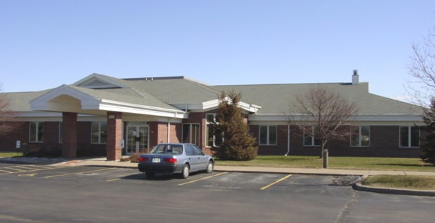
Property Detail
201 E Bell St
09-1701-0000
CSM 7915 LOT 1
Commercialnec
Winnebago
PDD
Wisconsin
B and X Area of moderate flood hazard, usually the area between the limits of the 100-year and 500-year floods.
1
0
3.49 AC
2025
Appleton/Oshkosh
003704
Other Market Areas
23,185 SF
Oshkosh-Neenah, WI
NEARBY LISTINGS FOR SALE OR LEASE
DEMOGRAPHICS near 201 E Bell St
1 mile
3 mile
5 mile
2025 Total Population
8,223
31,149
54,069
2030 Population
8,255
31,409
54,605
Pop Growth 2025-2030
+ 0.39%
+ 0.83%
+ 0.99%
Average Age
41
40
41
2025 Total Households
3,475
13,196
23,008
HH Growth 2025-2030
+ 0.49%
+ 0.80%
+ 0.93%
Median Household Inc
$90,442
$74,645
$72,957
Avg Household Size
2.30
2.30
2.30
2025 Avg HH Vehicles
2.00
2.00
2.00
Median Home Value
$294,616
$217,677
$210,522
Median Year Built
1977
1968
1970
Nearby Places
Map Layers
Map Styles
 Street
 Aerial
Layers
 Traffic
 Biking
Places
Listings with unknown addresses are not visible on the map
- Restaurants
- Banks
- Shops
- Fitness
- Groceries
PUBLIC TRANSPORTATION
AIRPORT
Appleton International
Drive
Walk
Distance
Appleton International
20 min
11.3 mi
Green Bay/Austin Straubel International
Drive
Walk
Distance
Green Bay/Austin Straubel International
50 min
36.4 mi
Nearby Properties
Address
Land Use
TOTAL SIZE
Lot Size
Zoning
Address
Land Use
TOTAL SIZE
Lot Size
Zoning
1,975 SF
2.40 AC
M2
Address
Land Use
TOTAL SIZE
Lot Size
Zoning
Address
Land Use
TOTAL SIZE
Lot Size
Zoning
9.40 AC
Address
Land Use
TOTAL SIZE
Lot Size
Zoning
800 SF
19.84 AC
I1
Address
Land Use
TOTAL SIZE
Lot Size
Zoning
178,750 SF
C2
Address
Land Use
TOTAL SIZE
Lot Size
Zoning
59,584 SF
12.11 AC
C1
Address
Land Use
TOTAL SIZE
Lot Size
Zoning
103,427 SF
PDD
Address
Land Use
TOTAL SIZE
Lot Size
Zoning
89,042 SF
2.83 AC
C2
Address
Land Use
TOTAL SIZE
Lot Size
Zoning
89,576 SF
1.03 AC
C2
Address
Land Use
TOTAL SIZE
Lot Size
Zoning
105,852 SF
0.39 AC
PDD
Address
Land Use
TOTAL SIZE
Lot Size
Zoning
29.32 AC
I1
Address
Land Use
TOTAL SIZE
Lot Size
Zoning
67.41 AC
I2
Address
Land Use
TOTAL SIZE
Lot Size
Zoning
86,455 SF
PDD
Address
Land Use
TOTAL SIZE
Lot Size
Zoning
210,214 SF
16.44 AC
I1
Address
Land Use
TOTAL SIZE
Lot Size
Zoning
361,899 SF
18.54 AC
I2
Address
Land Use
TOTAL SIZE
Lot Size
Zoning
115,151 SF
11.71 AC
PDD
Address
Land Use
TOTAL SIZE
Lot Size
Zoning
139,871 SF
11.14 AC
C1
Address
Land Use
TOTAL SIZE
Lot Size
Zoning
74,603 SF
4.96 AC
I1
Address
Land Use
TOTAL SIZE
Lot Size
Zoning
145,322 SF
11.20 AC
PDD
Address
Land Use
TOTAL SIZE
Lot Size
Zoning
10.13 AC
M2
Address
Land Use
TOTAL SIZE
Lot Size
Zoning
92,039 SF
13.55 AC
I2
Address
Land Use
TOTAL SIZE
Lot Size
Zoning
9.27 AC
I1
Address
Land Use
TOTAL SIZE
Lot Size
Zoning
92,030 SF
7.79 AC
I1
Address
Land Use
TOTAL SIZE
Lot Size
Zoning
31,400 SF
0.37 AC
PDD
Address
Land Use
TOTAL SIZE
Lot Size
Zoning
48,933 SF
2.80 AC
PDD
Address
Land Use
TOTAL SIZE
Lot Size
Zoning
22.72 AC
I1
Address
Land Use
TOTAL SIZE
Lot Size
Zoning
6.61 AC
I2
Address
Land Use
TOTAL SIZE
Lot Size
Zoning
80,914 SF
1.30 AC
C2
Address
Land Use
TOTAL SIZE
Lot Size
Zoning
37,672 SF
5.26 AC
PDD
Address
Land Use
TOTAL SIZE
Lot Size
Zoning
117,640 SF
7.45 AC
I1
The World's #1 Commercial Real Estate Marketplace
Connect with us
© 2026 CoStar Group
The information above has been obtained from sources believed reliable. While we do not doubt its accuracy we have not verified it and make no guarantee, warranty or representation about it. It is your responsibility to independently confirm its accuracy and completeness. Any projections, opinions, assumptions, or estimates used are for example only and do not represent the current or future performance of the property. The value of this transaction to you depends on tax and other factors which should be evaluated by your tax, financial, and legal advisors. You and your advisors should conduct a careful, independent investigation of the property to determine to your satisfaction the suitability of the property for your needs.