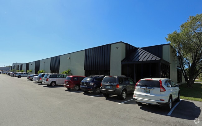
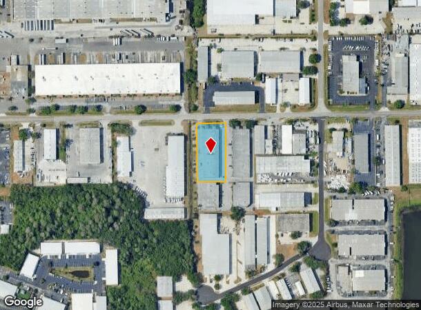
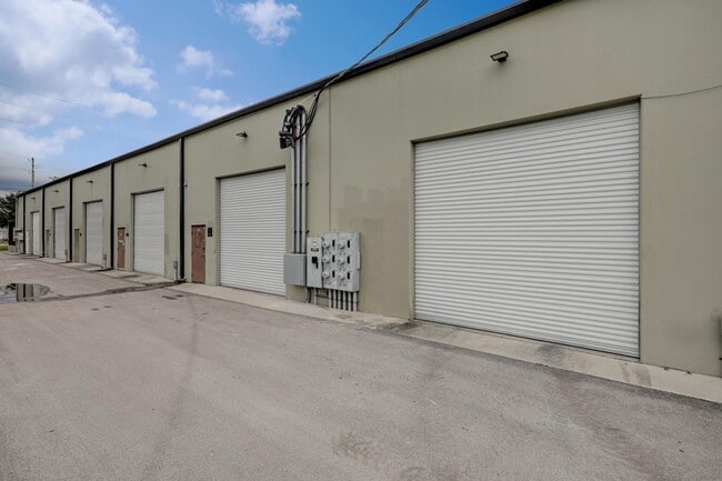
Property Record
201 Douglas Rd E, Oldsmar, FL 34677

Current Lease Availabilities
NEARBY LISTINGS FOR SALE OR LEASE
Property Detail
201 Douglas Rd E
Tampa-St. Petersburg-Clearwater, FL
Pt Of Ne 1/4 Of Nw 1/4 Of
24-28-16-00000-210-0810
PT OF NE 1/4 OF NW 1/4 OF SEC 24-28-16 TOGETHER WITH PART OF BLK V OF REV MAP OF OLDSMAR ALL DESC FROM NE COR OF NW 1/4 OF NE 1/4 TH S89D2145W 30FT TH S00D1959E 30FT TH S89D 2145W 2319.07FT FOR POB TH S00D0008E 293.03FT TH S89D5952W 143FT TH N00D 000
Officebuilding
Pinellas
AE
Florida
12103C0091H
810
2024
0.96 AC
2025
North Pinellas
027327
Tampa/St Petersburg
21,504 SF
DEMOGRAPHICS near 201 Douglas Rd E
1 mile
3 mile
5 mile
2024 Total Population
2,845
44,866
151,633
2029 Population
2,807
46,136
156,549
Pop Growth 2024-2029
(1.34%)
+ 2.83%
+ 3.24%
Average Age
41
43
43
2024 Total Households
1,062
18,596
63,756
HH Growth 2024-2029
(1.69%)
+ 2.72%
+ 2.98%
Median Household Inc
$71,249
$88,829
$81,612
Avg Household Size
2.60
2.40
2.30
2024 Avg HH Vehicles
2.00
2.00
2.00
Median Home Value
$342,161
$355,585
$343,691
Median Year Built
1988
1989
1988
Nearby Places
Map Layers
Map Styles
 Street
 Aerial
Transit
 Traffic
 Biking
Places
Listings with unknown addresses are not visible on the map
- Restaurants
- Banks
- Shops
- Fitness
- Groceries
PUBLIC TRANSPORTATION
AIRPORT
Tampa International
Drive
Walk
Distance
Tampa International
23 min
12.3 mi
St Pete-Clearwater International
Drive
Walk
Distance
St Pete-Clearwater International
22 min
12.6 mi
Nearby Properties
Address
Land Use
TOTAL SIZE
Lot Size
Zoning
Address
Land Use
TOTAL SIZE
Lot Size
Zoning
661,982 SF
19.26 AC
Address
Land Use
TOTAL SIZE
Lot Size
Zoning
536,079 SF
23.90 AC
PD
Address
Land Use
TOTAL SIZE
Lot Size
Zoning
399,137 SF
44.98 AC
PD
Address
Land Use
TOTAL SIZE
Lot Size
Zoning
374,906 SF
54.10 AC
PD
Address
Land Use
TOTAL SIZE
Lot Size
Zoning
449,097 SF
75.52 AC
PD
Address
Land Use
TOTAL SIZE
Lot Size
Zoning
358,185 SF
41.27 AC
PD
Address
Land Use
TOTAL SIZE
Lot Size
Zoning
323,386 SF
30.50 AC
PD
Address
Land Use
TOTAL SIZE
Lot Size
Zoning
473,742 SF
20.84 AC
Address
Land Use
TOTAL SIZE
Lot Size
Zoning
305,687 SF
31.48 AC
PD
Address
Land Use
TOTAL SIZE
Lot Size
Zoning
417,535 SF
42.47 AC
Address
Land Use
TOTAL SIZE
Lot Size
Zoning
427,299 SF
80.21 AC
PD
Address
Land Use
TOTAL SIZE
Lot Size
Zoning
311,117 SF
16.96 AC
Address
Land Use
TOTAL SIZE
Lot Size
Zoning
241,867 SF
19.54 AC
Address
Land Use
TOTAL SIZE
Lot Size
Zoning
234,591 SF
39.39 AC
PD
Address
Land Use
TOTAL SIZE
Lot Size
Zoning
173,673 SF
13.77 AC
PD
Address
Land Use
TOTAL SIZE
Lot Size
Zoning
188,940 SF
24.78 AC
PD
Address
Land Use
TOTAL SIZE
Lot Size
Zoning
177,360 SF
9.28 AC
Address
Land Use
TOTAL SIZE
Lot Size
Zoning
123,836 SF
15.17 AC
PD
Address
Land Use
TOTAL SIZE
Lot Size
Zoning
145,000 SF
1.26 AC
Address
Land Use
TOTAL SIZE
Lot Size
Zoning
126,644 SF
19.09 AC
Address
Land Use
TOTAL SIZE
Lot Size
Zoning
575,565 SF
335.60 AC
PD
Address
Land Use
TOTAL SIZE
Lot Size
Zoning
220,103 SF
28.40 AC
Address
Land Use
TOTAL SIZE
Lot Size
Zoning
14,334 SF
117.55 AC
Address
Land Use
TOTAL SIZE
Lot Size
Zoning
130,000 SF
11.27 AC
Address
Land Use
TOTAL SIZE
Lot Size
Zoning
102,074 SF
18.39 AC
Address
Land Use
TOTAL SIZE
Lot Size
Zoning
277,078 SF
35.38 AC
Address
Land Use
TOTAL SIZE
Lot Size
Zoning
122,912 SF
19.61 AC
Address
Land Use
TOTAL SIZE
Lot Size
Zoning
249,928 SF
79.57 AC
M1
Address
Land Use
TOTAL SIZE
Lot Size
Zoning
137,424 SF
9.93 AC
Address
Land Use
TOTAL SIZE
Lot Size
Zoning
100,896 SF
6.60 AC
PD
The World's #1 Commercial Real Estate Marketplace
Connect with us
© 2026 CoStar Group
The information above has been obtained from sources believed reliable. While we do not doubt its accuracy we have not verified it and make no guarantee, warranty or representation about it. It is your responsibility to independently confirm its accuracy and completeness. Any projections, opinions, assumptions, or estimates used are for example only and do not represent the current or future performance of the property. The value of this transaction to you depends on tax and other factors which should be evaluated by your tax, financial, and legal advisors. You and your advisors should conduct a careful, independent investigation of the property to determine to your satisfaction the suitability of the property for your needs.