Property Record
201 E Main St, Danville, IN 46122
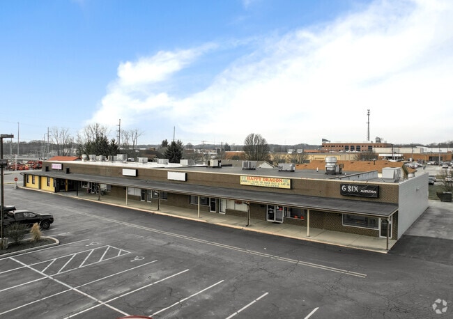

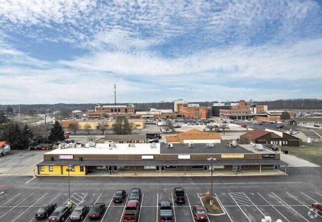
Property Detail
201 E Main St
32-11-02-384-002.000-003
OLD FARM ADD SEC 1 PT PARCEL F 6.860AC
Stripcommercialcenter
HENDRICKS
B and X Area of moderate flood hazard, usually the area between the limits of the 100-year and 500-year floods.
Indiana
2024
6.86 AC
2025
Hendricks County
210502
Indianapolis
12,360 SF
Indianapolis-Carmel-Greenwood, IN
NEARBY LISTINGS FOR SALE OR LEASE
DEMOGRAPHICS near 201 E Main St
1 mile
3 mile
5 mile
2025 Total Population
4,139
16,333
30,169
2030 Population
4,466
17,691
32,462
Pop Growth 2025-2030
+ 7.90%
+ 8.31%
+ 7.60%
Average Age
41
40
42
2025 Total Households
1,595
6,210
11,409
HH Growth 2025-2030
+ 8.15%
+ 8.53%
+ 7.80%
Median Household Inc
$78,651
$91,166
$96,580
Avg Household Size
2.50
2.60
2.60
2025 Avg HH Vehicles
2.00
2.00
2.00
Median Home Value
$302,537
$308,297
$333,494
Median Year Built
1996
1993
1994
Nearby Places
Map Layers
Map Styles
 Street
 Aerial
Transit
 Traffic
 Biking
Places
Listings with unknown addresses are not visible on the map
- Restaurants
- Banks
- Shops
- Fitness
- Groceries
PUBLIC TRANSPORTATION
AIRPORT
Indianapolis International
Drive
Walk
Distance
Indianapolis International
32 min
16.5 mi
SALE & LEASE HISTORY
LISTING DATE
SALE/LEASE

Sep 25, 2016
For Lease
May 09, 2019
For Lease
Nearby Properties
Address
Land Use
TOTAL SIZE
Lot Size
Zoning
Address
Land Use
TOTAL SIZE
Lot Size
Zoning
15,912 SF
29.86 AC
Address
Land Use
TOTAL SIZE
Lot Size
Zoning
100 SF
5.07 AC
Address
Land Use
TOTAL SIZE
Lot Size
Zoning
10,528 SF
12.54 AC
Address
Land Use
TOTAL SIZE
Lot Size
Zoning
156,080 SF
15.18 AC
Address
Land Use
TOTAL SIZE
Lot Size
Zoning
10,500 SF
10 AC
Address
Land Use
TOTAL SIZE
Lot Size
Zoning
55,285 SF
5 AC
Address
Land Use
TOTAL SIZE
Lot Size
Zoning
64,062 SF
7.53 AC
Address
Land Use
TOTAL SIZE
Lot Size
Zoning
43,482 SF
10 AC
Address
Land Use
TOTAL SIZE
Lot Size
Zoning
17,100 SF
5.99 AC
Address
Land Use
TOTAL SIZE
Lot Size
Zoning
3,114 SF
3.04 AC
Address
Land Use
TOTAL SIZE
Lot Size
Zoning
19,932 SF
12.34 AC
Address
Land Use
TOTAL SIZE
Lot Size
Zoning
2,244 SF
9.86 AC
Address
Land Use
TOTAL SIZE
Lot Size
Zoning
29,586 SF
7.44 AC
Address
Land Use
TOTAL SIZE
Lot Size
Zoning
18,970 SF
3.26 AC
Address
Land Use
TOTAL SIZE
Lot Size
Zoning
5,600 SF
12.29 AC
Address
Land Use
TOTAL SIZE
Lot Size
Zoning
6,023 SF
4.32 AC
Address
Land Use
TOTAL SIZE
Lot Size
Zoning
26,899 SF
3 AC
Address
Land Use
TOTAL SIZE
Lot Size
Zoning
24,820 SF
9.59 AC
Address
Land Use
TOTAL SIZE
Lot Size
Zoning
17,904 SF
14.34 AC
Address
Land Use
TOTAL SIZE
Lot Size
Zoning
16,000 SF
1.42 AC
Address
Land Use
TOTAL SIZE
Lot Size
Zoning
12,480 SF
2.82 AC
Address
Land Use
TOTAL SIZE
Lot Size
Zoning
10,920 SF
5.97 AC
Address
Land Use
TOTAL SIZE
Lot Size
Zoning
12,000 SF
4.66 AC
Address
Land Use
TOTAL SIZE
Lot Size
Zoning
4,476 SF
3.20 AC
Address
Land Use
TOTAL SIZE
Lot Size
Zoning
9,547 SF
16.64 AC
Address
Land Use
TOTAL SIZE
Lot Size
Zoning
Address
Land Use
TOTAL SIZE
Lot Size
Zoning
5,075 SF
2.13 AC
Address
Land Use
TOTAL SIZE
Lot Size
Zoning
48,150 SF
5 AC
Address
Land Use
TOTAL SIZE
Lot Size
Zoning
37,976 SF
3.03 AC
The World's #1 Commercial Real Estate Marketplace
Connect with us
© 2026 CoStar Group
The information above has been obtained from sources believed reliable. While we do not doubt its accuracy we have not verified it and make no guarantee, warranty or representation about it. It is your responsibility to independently confirm its accuracy and completeness. Any projections, opinions, assumptions, or estimates used are for example only and do not represent the current or future performance of the property. The value of this transaction to you depends on tax and other factors which should be evaluated by your tax, financial, and legal advisors. You and your advisors should conduct a careful, independent investigation of the property to determine to your satisfaction the suitability of the property for your needs.