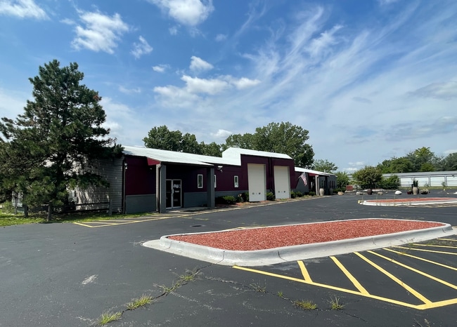
Property Record
201 E Romeo Rd, Romeoville, IL 60446

Current Lease Availabilities
NEARBY LISTINGS FOR SALE OR LEASE
Property Detail
201 E Romeo Rd
11-04-03-200-029
THAT PRT OF THE NW1/4 OF THE NE1/4 OF SEC. 3, T36N-R10E, DAF: BEG AT PT ON S'LY ROW LN IN ROMEOVILLE RD WHICH IS THE N1/4 OF
Commercialnec
Will
X
Illinois
17197C0065G
1.92 AC
2024
South I-55 Corridor
2024
Chicago
884101
Chicago-Naperville-Elgin, IL-IN-WI
DEMOGRAPHICS near 201 E Romeo Rd
1 Mile
3 Mile
5 Mile
2024 Total Population
5,077
27,723
143,843
2029 Population
5,035
27,667
142,875
Pop Growth 2024-2029
(0.83%)
(0.20%)
(0.67%)
Average Age
37
40
40
2024 Total Households
1,609
9,648
49,738
HH Growth 2024-2029
(0.87%)
(0.19%)
(0.67%)
Median Household Inc
$72,135
$86,195
$90,053
Avg Household Size
3.10
2.80
2.80
2024 Avg HH Vehicles
2.00
2.00
2.00
Median Home Value
$160,613
$223,014
$252,572
Median Year Built
1966
1988
1992
Nearby Places
Map Layers
Map Styles
 Street
 Aerial
- Restaurants
- Banks
- Shops
- Fitness
- Groceries
PUBLIC TRANSPORTATION
COMMUTER RAIL
DRIVE
WALK
Distance
4 min
1.6 mi
Lockport Station (Heritage Corridor Line - Northeast Illinois Regional Commuter Railroad (Metra))
DRIVE
WALK
Distance
Lockport Station (Heritage Corridor Line - Northeast Illinois Regional Commuter Railroad (Metra))
10 min
4.9 mi
AIRPORT
Chicago Midway International
DRIVE
WALK
Distance
Chicago Midway International
34 min
22.2 mi
Chicago O'Hare International
DRIVE
WALK
Distance
Chicago O'Hare International
51 min
33.6 mi
Nearby Properties
Address
Land Use
TOTAL SIZE
Lot Size
Zoning
Address
Land Use
TOTAL SIZE
Lot Size
Zoning
122.95 AC
Address
Land Use
TOTAL SIZE
Lot Size
Zoning
32.82 AC
Address
Land Use
TOTAL SIZE
Lot Size
Zoning
115.36 AC
Address
Land Use
TOTAL SIZE
Lot Size
Zoning
1,107,073 SF
35.03 AC
Address
Land Use
TOTAL SIZE
Lot Size
Zoning
59.76 AC
Address
Land Use
TOTAL SIZE
Lot Size
Zoning
Address
Land Use
TOTAL SIZE
Lot Size
Zoning
48.28 AC
Address
Land Use
TOTAL SIZE
Lot Size
Zoning
62.35 AC
Address
Land Use
TOTAL SIZE
Lot Size
Zoning
37.47 AC
Address
Land Use
TOTAL SIZE
Lot Size
Zoning
28.82 AC
Address
Land Use
TOTAL SIZE
Lot Size
Zoning
48.48 AC
Address
Land Use
TOTAL SIZE
Lot Size
Zoning
49.91 AC
Address
Land Use
TOTAL SIZE
Lot Size
Zoning
751,809 SF
36.59 AC
Address
Land Use
TOTAL SIZE
Lot Size
Zoning
806,164 SF
35.45 AC
Address
Land Use
TOTAL SIZE
Lot Size
Zoning
Address
Land Use
TOTAL SIZE
Lot Size
Zoning
698,727 SF
40.97 AC
Address
Land Use
TOTAL SIZE
Lot Size
Zoning
39.75 AC
Address
Land Use
TOTAL SIZE
Lot Size
Zoning
50.08 AC
Address
Land Use
TOTAL SIZE
Lot Size
Zoning
723,073 SF
37.46 AC
Address
Land Use
TOTAL SIZE
Lot Size
Zoning
652,056 SF
26.43 AC
Address
Land Use
TOTAL SIZE
Lot Size
Zoning
691,629 SF
32.73 AC
Address
Land Use
TOTAL SIZE
Lot Size
Zoning
Address
Land Use
TOTAL SIZE
Lot Size
Zoning
604,084 SF
32.65 AC
Address
Land Use
TOTAL SIZE
Lot Size
Zoning
12.52 AC
Address
Land Use
TOTAL SIZE
Lot Size
Zoning
12.84 AC
Address
Land Use
TOTAL SIZE
Lot Size
Zoning
270,372 SF
12.49 AC
Address
Land Use
TOTAL SIZE
Lot Size
Zoning
28.15 AC
Address
Land Use
TOTAL SIZE
Lot Size
Zoning
26.25 AC
Address
Land Use
TOTAL SIZE
Lot Size
Zoning
557,851 SF
25.47 AC
Address
Land Use
TOTAL SIZE
Lot Size
Zoning
531,348 SF
24.95 AC
The World's #1 Commercial Real Estate Marketplace
Connect with us
© 2025 CoStar Group
The information above has been obtained from sources believed reliable. While we do not doubt its accuracy we have not verified it and make no guarantee, warranty or representation about it. It is your responsibility to independently confirm its accuracy and completeness. Any projections, opinions, assumptions, or estimates used are for example only and do not represent the current or future performance of the property. The value of this transaction to you depends on tax and other factors which should be evaluated by your tax, financial, and legal advisors. You and your advisors should conduct a careful, independent investigation of the property to determine to your satisfaction the suitability of the property for your needs.