Property Record
201 E Water St, Pendleton, IN 46064
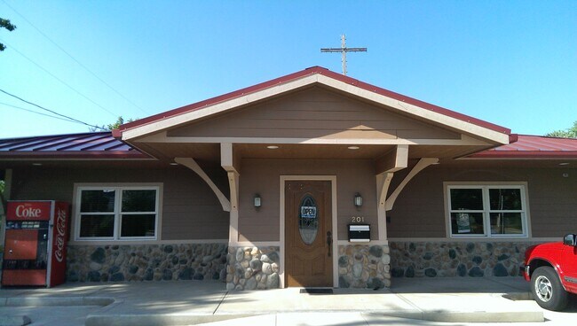

Property Detail
201 E Water St
Indianapolis-Carmel-Greenwood, IN
HOLLOWELLS 2NDLOTS 5,6,,10,11 16-18-7 (1.661AC)
48-14-16-300-016.000-013
MADISON
Publicstorage
Indiana
B and X Area of moderate flood hazard, usually the area between the limits of the 100-year and 500-year floods.
5-6
2024
1.66 AC
2025
Anderson/Madison Cnty
011700
Indianapolis
3,300 SF
NEARBY LISTINGS FOR SALE OR LEASE
DEMOGRAPHICS near 201 E Water St
1 mile
3 mile
5 mile
2025 Total Population
3,596
12,256
21,267
2030 Population
3,715
12,515
21,725
Pop Growth 2025-2030
+ 3.31%
+ 2.11%
+ 2.15%
Average Age
42
43
43
2025 Total Households
1,457
3,645
7,219
HH Growth 2025-2030
+ 3.43%
+ 2.58%
+ 2.48%
Median Household Inc
$89,612
$92,237
$87,671
Avg Household Size
2.40
2.50
2.40
2025 Avg HH Vehicles
2.00
2.00
2.00
Median Home Value
$263,289
$291,130
$246,525
Median Year Built
1970
1977
1977
Nearby Places
Map Layers
Map Styles
 Street
 Aerial
Transit
 Traffic
 Biking
Places
Listings with unknown addresses are not visible on the map
- Restaurants
- Banks
- Shops
- Fitness
- Groceries
PUBLIC TRANSPORTATION
AIRPORT
Indianapolis International
Drive
Walk
Distance
Indianapolis International
66 min
45.8 mi
SALE & LEASE HISTORY
LISTING DATE
SALE/LEASE

Apr 08, 2025
For Lease
Nearby Properties
Address
Land Use
TOTAL SIZE
Lot Size
Zoning
Address
Land Use
TOTAL SIZE
Lot Size
Zoning
256,290 SF
77.35 AC
Address
Land Use
TOTAL SIZE
Lot Size
Zoning
727,832 SF
46.15 AC
Address
Land Use
TOTAL SIZE
Lot Size
Zoning
399,763 SF
40 AC
Address
Land Use
TOTAL SIZE
Lot Size
Zoning
324,931 SF
25.40 AC
Address
Land Use
TOTAL SIZE
Lot Size
Zoning
117,536 SF
14.44 AC
Address
Land Use
TOTAL SIZE
Lot Size
Zoning
325,122 SF
40 AC
Address
Land Use
TOTAL SIZE
Lot Size
Zoning
160,230 SF
15 AC
Address
Land Use
TOTAL SIZE
Lot Size
Zoning
222,080 SF
25 AC
Address
Land Use
TOTAL SIZE
Lot Size
Zoning
140,000 SF
19.36 AC
Address
Land Use
TOTAL SIZE
Lot Size
Zoning
77,500 SF
8.42 AC
Address
Land Use
TOTAL SIZE
Lot Size
Zoning
35,040 SF
11.40 AC
Address
Land Use
TOTAL SIZE
Lot Size
Zoning
32,361 SF
2.88 AC
Address
Land Use
TOTAL SIZE
Lot Size
Zoning
17,729 SF
6.62 AC
Address
Land Use
TOTAL SIZE
Lot Size
Zoning
18,780 SF
2.59 AC
Address
Land Use
TOTAL SIZE
Lot Size
Zoning
47,370 SF
11.23 AC
Address
Land Use
TOTAL SIZE
Lot Size
Zoning
44,660 SF
10 AC
Address
Land Use
TOTAL SIZE
Lot Size
Zoning
17,729 SF
3.38 AC
Address
Land Use
TOTAL SIZE
Lot Size
Zoning
70,000 SF
10.07 AC
Address
Land Use
TOTAL SIZE
Lot Size
Zoning
115,522 SF
20 AC
Address
Land Use
TOTAL SIZE
Lot Size
Zoning
44,699 SF
4.94 AC
Address
Land Use
TOTAL SIZE
Lot Size
Zoning
51,047 SF
4.42 AC
Address
Land Use
TOTAL SIZE
Lot Size
Zoning
19,278 SF
1.76 AC
Address
Land Use
TOTAL SIZE
Lot Size
Zoning
60,000 SF
6.71 AC
Address
Land Use
TOTAL SIZE
Lot Size
Zoning
71,278 SF
7.59 AC
Address
Land Use
TOTAL SIZE
Lot Size
Zoning
21,020 SF
1.15 AC
Address
Land Use
TOTAL SIZE
Lot Size
Zoning
21,641 SF
4.91 AC
Address
Land Use
TOTAL SIZE
Lot Size
Zoning
32,586 SF
3.65 AC
Address
Land Use
TOTAL SIZE
Lot Size
Zoning
30,560 SF
11.27 AC
Address
Land Use
TOTAL SIZE
Lot Size
Zoning
6,660 SF
1.39 AC
Address
Land Use
TOTAL SIZE
Lot Size
Zoning
5,469 SF
2.67 AC
The World's #1 Commercial Real Estate Marketplace
Connect with us
© 2026 CoStar Group
The information above has been obtained from sources believed reliable. While we do not doubt its accuracy we have not verified it and make no guarantee, warranty or representation about it. It is your responsibility to independently confirm its accuracy and completeness. Any projections, opinions, assumptions, or estimates used are for example only and do not represent the current or future performance of the property. The value of this transaction to you depends on tax and other factors which should be evaluated by your tax, financial, and legal advisors. You and your advisors should conduct a careful, independent investigation of the property to determine to your satisfaction the suitability of the property for your needs.