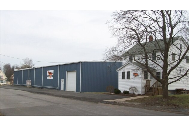
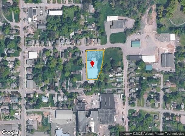
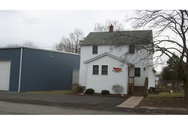
Property Record
201 Ford St, Newark, NY 14513
NEARBY LISTINGS FOR SALE OR LEASE
-
-
View all Newark listings for lease on LoopNet.com
Property Detail
201 Ford St
Rochester, NY
Wayne
542001-068-111-0018-401-218-0000
New York
Vehiclerentalsvehiclesales
401.218
2025
0.88 AC
2024
Wayne County
021200
Rochester
16,138 SF
DEMOGRAPHICS near 201 Ford St
1 Mile
3 Mile
5 Mile
2024 Total Population
6,143
11,356
16,061
2029 Population
6,068
11,223
15,863
Pop Growth 2024-2029
(1.22%)
(1.17%)
(1.23%)
Average Age
42
43
43
2024 Total Households
2,635
4,853
6,758
HH Growth 2024-2029
(1.33%)
(1.30%)
(1.33%)
Median Household Inc
$53,661
$54,925
$58,113
Avg Household Size
2.20
2.20
2.20
2024 Avg HH Vehicles
2.00
2.00
2.00
Median Home Value
$95,021
$114,476
$121,341
Median Year Built
1951
1956
1957
Nearby Places
- Restaurants
- Banks
- Shops
- Fitness
- Groceries
PUBLIC TRANSPORTATION
AIRPORT
Frederick Douglass/Greater Rochester International
DRIVE
WALK
Distance
Frederick Douglass/Greater Rochester International
49 min
33.8 mi
Freight Ports
Albany, NY Port
DRIVE
WALK
Distance
Albany, NY Port
237 min
201.8 mi
SALE & LEASE HISTORY
LISTING DATE
SALE/LEASE

Sep 25, 2016
For Lease
Sep 24, 2016
For Sale
Oct 25, 2017
For Lease
Oct 25, 2017
For Sale
Nearby Properties
Address
Land Use
TOTAL SIZE
Lot Size
Zoning
Address
Land Use
TOTAL SIZE
Lot Size
Zoning
200,670 SF
23.13 AC
B1
Address
Land Use
TOTAL SIZE
Lot Size
Zoning
205,485 SF
35.22 AC
PD
Address
Land Use
TOTAL SIZE
Lot Size
Zoning
153,072 SF
33.68 AC
PID
Address
Land Use
TOTAL SIZE
Lot Size
Zoning
53,312 SF
44.89 AC
PD
Address
Land Use
TOTAL SIZE
Lot Size
Zoning
152,676 SF
27.02 AC
B3
Address
Land Use
TOTAL SIZE
Lot Size
Zoning
39,000 SF
21.49 AC
B3
Address
Land Use
TOTAL SIZE
Lot Size
Zoning
141,523 SF
19.12 AC
PD
Address
Land Use
TOTAL SIZE
Lot Size
Zoning
128,734 SF
16.07 AC
PD
Address
Land Use
TOTAL SIZE
Lot Size
Zoning
65,080 SF
45.77 AC
PD
Address
Land Use
TOTAL SIZE
Lot Size
Zoning
1,600 SF
31.69 AC
R2
Address
Land Use
TOTAL SIZE
Lot Size
Zoning
82,148 SF
13.58 AC
PID
Address
Land Use
TOTAL SIZE
Lot Size
Zoning
15,036 SF
5.26 AC
PD
Address
Land Use
TOTAL SIZE
Lot Size
Zoning
34,909 SF
8.09 AC
R2
Address
Land Use
TOTAL SIZE
Lot Size
Zoning
1,684 SF
19.70 AC
R1
Address
Land Use
TOTAL SIZE
Lot Size
Zoning
14,830 SF
3.45 AC
B3
Address
Land Use
TOTAL SIZE
Lot Size
Zoning
13,309 SF
0.94 AC
B2
Address
Land Use
TOTAL SIZE
Lot Size
Zoning
96,496 SF
7.13 AC
B3
Address
Land Use
TOTAL SIZE
Lot Size
Zoning
3.64 AC
CON
Address
Land Use
TOTAL SIZE
Lot Size
Zoning
74.50 AC
CON
Address
Land Use
TOTAL SIZE
Lot Size
Zoning
147,918 SF
66.58 AC
PID
Address
Land Use
TOTAL SIZE
Lot Size
Zoning
36,739 SF
23.16 AC
CON
Address
Land Use
TOTAL SIZE
Lot Size
Zoning
21,627 SF
2.67 AC
R1
Address
Land Use
TOTAL SIZE
Lot Size
Zoning
68,330 SF
2.26 AC
B2
Address
Land Use
TOTAL SIZE
Lot Size
Zoning
1,336 SF
7.53 AC
R2
Address
Land Use
TOTAL SIZE
Lot Size
Zoning
91.90 AC
04 - FARM
Address
Land Use
TOTAL SIZE
Lot Size
Zoning
91,319 SF
5.96 AC
PID
Address
Land Use
TOTAL SIZE
Lot Size
Zoning
97,037 SF
3.10 AC
PD
Address
Land Use
TOTAL SIZE
Lot Size
Zoning
17,500 SF
6.42 AC
PID
Address
Land Use
TOTAL SIZE
Lot Size
Zoning
41,818 SF
0.96 AC
R2
Address
Land Use
TOTAL SIZE
Lot Size
Zoning
90,645 SF
7.16 AC
PD
The World's #1 Commercial Real Estate Marketplace
Connect with us
© 2025 CoStar Group
The information above has been obtained from sources believed reliable. While we do not doubt its accuracy we have not verified it and make no guarantee, warranty or representation about it. It is your responsibility to independently confirm its accuracy and completeness. Any projections, opinions, assumptions, or estimates used are for example only and do not represent the current or future performance of the property. The value of this transaction to you depends on tax and other factors which should be evaluated by your tax, financial, and legal advisors. You and your advisors should conduct a careful, independent investigation of the property to determine to your satisfaction the suitability of the property for your needs.