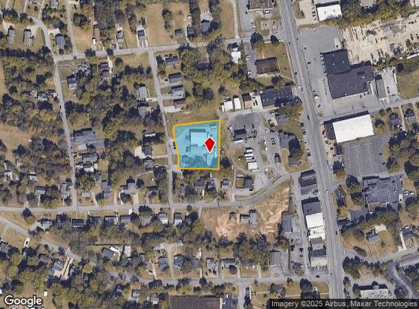
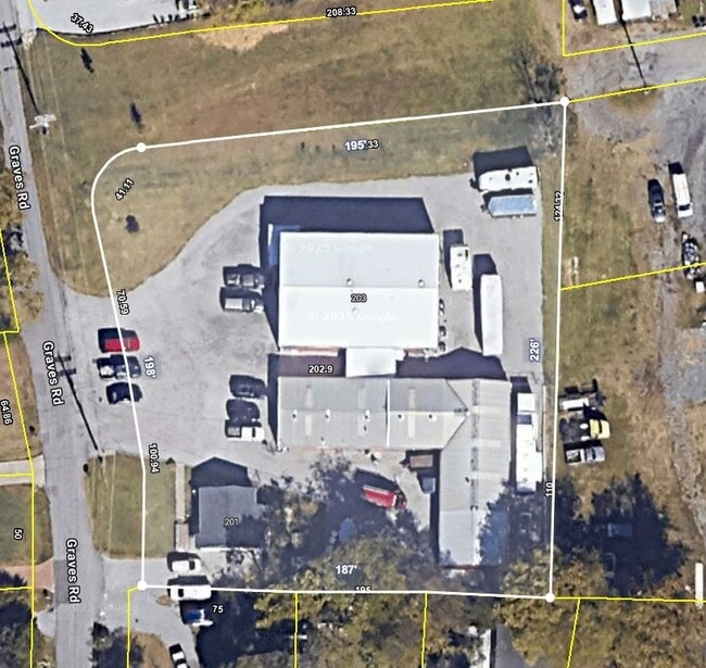
Property Record
201 Graves Rd, Goodlettsville, TN 37072
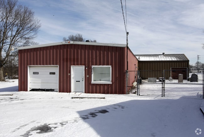
This Property Is For Sale
NEARBY LISTINGS FOR SALE OR LEASE
Property Detail
201 Graves Rd
Nashville-Davidson--Murfreesboro--Franklin, TN
Young
018-16-0-154
Davidson
Sfr
Tennessee
X
1 AC
47037C0129J
West
732 SF
Nashville
DEMOGRAPHICS near 201 Graves Rd
1 Mile
3 Mile
5 Mile
2024 Total Population
3,718
26,301
66,322
2029 Population
3,686
26,829
68,047
Pop Growth 2024-2029
(0.86%)
+ 2.01%
+ 2.60%
Average Age
40
41
40
2024 Total Households
1,518
10,591
26,829
HH Growth 2024-2029
(1.45%)
+ 1.26%
+ 2.14%
Median Household Inc
$58,632
$61,852
$61,761
Avg Household Size
2.40
2.40
2.40
2024 Avg HH Vehicles
2.00
2.00
2.00
Median Home Value
$311,765
$303,844
$285,003
Median Year Built
1991
1990
1985
Nearby Places
Map Layers
Map Styles
 Street
 Aerial
- Restaurants
- Banks
- Shops
- Fitness
- Groceries
PUBLIC TRANSPORTATION
AIRPORT
Nashville International
DRIVE
WALK
Distance
Nashville International
29 min
22.1 mi
Freight Ports
Port of Mobile
DRIVE
WALK
Distance
Port of Mobile
502 min
459.6 mi
Nearby Properties
Address
Land Use
TOTAL SIZE
Lot Size
Zoning
Address
Land Use
TOTAL SIZE
Lot Size
Zoning
102,431 SF
19.59 AC
6ZZ
Address
Land Use
TOTAL SIZE
Lot Size
Zoning
16,770 SF
76.79 AC
RM4
Address
Land Use
TOTAL SIZE
Lot Size
Zoning
17,214 SF
40.52 AC
RM9
Address
Land Use
TOTAL SIZE
Lot Size
Zoning
31,528 SF
17.61 AC
6ZZ
Address
Land Use
TOTAL SIZE
Lot Size
Zoning
26,872 SF
24.16 AC
6ZZ
Address
Land Use
TOTAL SIZE
Lot Size
Zoning
72,951 SF
5.31 AC
6ZZ
Address
Land Use
TOTAL SIZE
Lot Size
Zoning
3,993 SF
21.86 AC
6ZZ
Address
Land Use
TOTAL SIZE
Lot Size
Zoning
42,840 SF
21.43 AC
CS
Address
Land Use
TOTAL SIZE
Lot Size
Zoning
12,576 SF
16.09 AC
6ZZ
Address
Land Use
TOTAL SIZE
Lot Size
Zoning
34,752 SF
19.09 AC
CS
Address
Land Use
TOTAL SIZE
Lot Size
Zoning
112,056 SF
40.15 AC
MULTIZONE
Address
Land Use
TOTAL SIZE
Lot Size
Zoning
26,610 SF
6.66 AC
RS20
Address
Land Use
TOTAL SIZE
Lot Size
Zoning
21,356 SF
11.25 AC
6ZZ
Address
Land Use
TOTAL SIZE
Lot Size
Zoning
28,000 SF
38.86 AC
6ZZ
Address
Land Use
TOTAL SIZE
Lot Size
Zoning
10,312 SF
15.03 AC
6ZZ
Address
Land Use
TOTAL SIZE
Lot Size
Zoning
17,500 SF
17.56 AC
SCR
Address
Land Use
TOTAL SIZE
Lot Size
Zoning
10,336 SF
17.70 AC
6ZZ
Address
Land Use
TOTAL SIZE
Lot Size
Zoning
15,600 SF
23.88 AC
RM9
Address
Land Use
TOTAL SIZE
Lot Size
Zoning
6,948 SF
12.62 AC
6ZZ
Address
Land Use
TOTAL SIZE
Lot Size
Zoning
44,394 SF
2.49 AC
Address
Land Use
TOTAL SIZE
Lot Size
Zoning
10,378 SF
15.33 AC
6ZZ
Address
Land Use
TOTAL SIZE
Lot Size
Zoning
18,482 SF
27 AC
6ZZ
Address
Land Use
TOTAL SIZE
Lot Size
Zoning
29,428 SF
6.56 AC
MULTI-ZONE
Address
Land Use
TOTAL SIZE
Lot Size
Zoning
32,296 SF
43.01 AC
6ZZ
Address
Land Use
TOTAL SIZE
Lot Size
Zoning
123,740 SF
26.49 AC
Address
Land Use
TOTAL SIZE
Lot Size
Zoning
81,680 SF
2.87 AC
6ZZ
Address
Land Use
TOTAL SIZE
Lot Size
Zoning
124,724 SF
7.25 AC
MULTIZONE
Address
Land Use
TOTAL SIZE
Lot Size
Zoning
4,000 SF
10.18 AC
MULTI-ZONE
Address
Land Use
TOTAL SIZE
Lot Size
Zoning
213,890 SF
10.11 AC
IR
Address
Land Use
TOTAL SIZE
Lot Size
Zoning
10,480 SF
17.37 AC
SP
The World's #1 Commercial Real Estate Marketplace
Connect with us
© 2026 CoStar Group
The information above has been obtained from sources believed reliable. While we do not doubt its accuracy we have not verified it and make no guarantee, warranty or representation about it. It is your responsibility to independently confirm its accuracy and completeness. Any projections, opinions, assumptions, or estimates used are for example only and do not represent the current or future performance of the property. The value of this transaction to you depends on tax and other factors which should be evaluated by your tax, financial, and legal advisors. You and your advisors should conduct a careful, independent investigation of the property to determine to your satisfaction the suitability of the property for your needs.