Property Record
201 Greenpoint Ct, High Point, NC 27265

Property Detail
201 Greenpoint Ct
Greensboro-High Point, NC
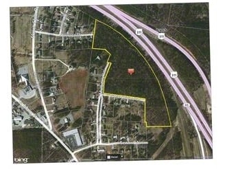
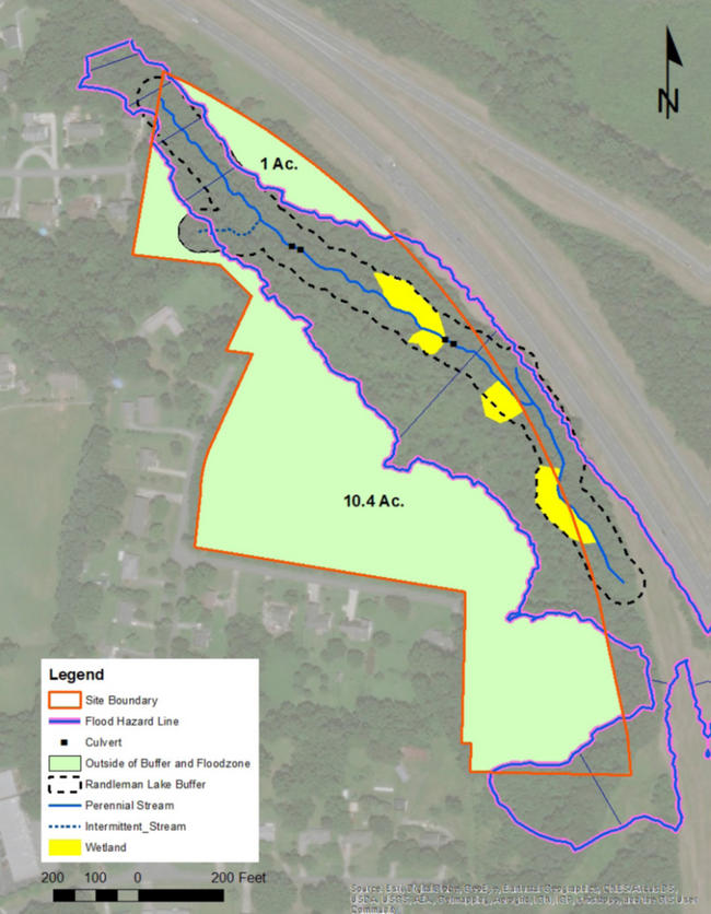
18.65 AC WINSTON RD
0198547
GUILFORD
Agriculturalland
North Carolina
R-3
13
B and X Area of moderate flood hazard, usually the area between the limits of the 100-year and 500-year floods.
18.65 AC
2024
High Point/SW Guilford Cty
2025
Greensboro/Winston-Salem
014407
NEARBY LISTINGS FOR SALE OR LEASE
DEMOGRAPHICS near 201 Greenpoint Ct
1 mile
3 mile
5 mile
2025 Total Population
4,720
36,294
103,054
2030 Population
4,844
37,363
107,030
Pop Growth 2025-2030
+ 2.63%
+ 2.95%
+ 3.86%
Average Age
42
41
40
2025 Total Households
2,012
15,144
40,148
HH Growth 2025-2030
+ 2.78%
+ 3.07%
+ 4.10%
Median Household Inc
$62,862
$69,168
$66,445
Avg Household Size
2.30
2.30
2.40
2025 Avg HH Vehicles
2.00
2.00
2.00
Median Home Value
$249,351
$253,677
$265,155
Median Year Built
1992
1984
1987
Nearby Places
Map Layers
Map Styles
 Street
 Aerial
Transit
 Traffic
 Biking
Places
Listings with unknown addresses are not visible on the map
- Restaurants
- Banks
- Shops
- Fitness
- Groceries
PUBLIC TRANSPORTATION
COMMUTER RAIL
High Point Station (Piedmont - North Carolina by Train (NC Train))
Drive
Walk
Distance
High Point Station (Piedmont - North Carolina by Train (NC Train))
10 min
4.5 mi
AIRPORT
Piedmont Triad International
Drive
Walk
Distance
Piedmont Triad International
27 min
12.7 mi
Freight Ports
Port of Wilmington
Drive
Walk
Distance
Port of Wilmington
256 min
217.2 mi
SALE & LEASE HISTORY
LISTING DATE
SALE/LEASE

Jul 19, 2019
For Sale
Jul 02, 2018
For Sale
Apr 12, 2022
For Sale
Nearby Properties
Address
Land Use
TOTAL SIZE
Lot Size
Zoning
Address
Land Use
TOTAL SIZE
Lot Size
Zoning
1,045,775 SF
114.96 AC
CZ-LI-HP
Address
Land Use
TOTAL SIZE
Lot Size
Zoning
25,648 SF
40.16 AC
PDR
Address
Land Use
TOTAL SIZE
Lot Size
Zoning
215,222 SF
15.14 AC
RC
Address
Land Use
TOTAL SIZE
Lot Size
Zoning
1.32 AC
PNR
Address
Land Use
TOTAL SIZE
Lot Size
Zoning
185,320 SF
15.08 AC
PI
Address
Land Use
TOTAL SIZE
Lot Size
Zoning
170,183 SF
13.94 AC
RM-16
Address
Land Use
TOTAL SIZE
Lot Size
Zoning
166,196 SF
19.99 AC
RM-16
Address
Land Use
TOTAL SIZE
Lot Size
Zoning
164,027 SF
12.52 AC
RM-16
Address
Land Use
TOTAL SIZE
Lot Size
Zoning
56,029 SF
9.36 AC
CU-GB
Address
Land Use
TOTAL SIZE
Lot Size
Zoning
181,106 SF
16.23 AC
RM-16
Address
Land Use
TOTAL SIZE
Lot Size
Zoning
161,377 SF
16.36 AC
CU-SC
Address
Land Use
TOTAL SIZE
Lot Size
Zoning
244,197 SF
14.76 AC
RM-26
Address
Land Use
TOTAL SIZE
Lot Size
Zoning
133,710 SF
8.70 AC
RM-16
Address
Land Use
TOTAL SIZE
Lot Size
Zoning
132,012 SF
12.99 AC
RM-16
Address
Land Use
TOTAL SIZE
Lot Size
Zoning
184,724 SF
15.71 AC
RM-16
Address
Land Use
TOTAL SIZE
Lot Size
Zoning
125,037 SF
13.89 AC
CU-GO-M
Address
Land Use
TOTAL SIZE
Lot Size
Zoning
74,786 SF
10.61 AC
GB
Address
Land Use
TOTAL SIZE
Lot Size
Zoning
666,462 SF
44.09 AC
RC
Address
Land Use
TOTAL SIZE
Lot Size
Zoning
67,497 SF
5.95 AC
RC
Address
Land Use
TOTAL SIZE
Lot Size
Zoning
110,750 SF
11.36 AC
GB
Address
Land Use
TOTAL SIZE
Lot Size
Zoning
49,030 SF
4.95 AC
OI
Address
Land Use
TOTAL SIZE
Lot Size
Zoning
146,216 SF
12.79 AC
RM-16
Address
Land Use
TOTAL SIZE
Lot Size
Zoning
99,064 SF
10 AC
RM-16
Address
Land Use
TOTAL SIZE
Lot Size
Zoning
119,536 SF
16.35 AC
RM-16
Address
Land Use
TOTAL SIZE
Lot Size
Zoning
96,744 SF
10.01 AC
RC
Address
Land Use
TOTAL SIZE
Lot Size
Zoning
70,023 SF
11.72 AC
PI
Address
Land Use
TOTAL SIZE
Lot Size
Zoning
4,707 SF
148 AC
PNR
Address
Land Use
TOTAL SIZE
Lot Size
Zoning
67,201 SF
2.66 AC
RC
Address
Land Use
TOTAL SIZE
Lot Size
Zoning
49,972 SF
5.84 AC
GB
Address
Land Use
TOTAL SIZE
Lot Size
Zoning
58,560 SF
7.25 AC
OI
The World's #1 Commercial Real Estate Marketplace
Connect with us
© 2026 CoStar Group
The information above has been obtained from sources believed reliable. While we do not doubt its accuracy we have not verified it and make no guarantee, warranty or representation about it. It is your responsibility to independently confirm its accuracy and completeness. Any projections, opinions, assumptions, or estimates used are for example only and do not represent the current or future performance of the property. The value of this transaction to you depends on tax and other factors which should be evaluated by your tax, financial, and legal advisors. You and your advisors should conduct a careful, independent investigation of the property to determine to your satisfaction the suitability of the property for your needs.