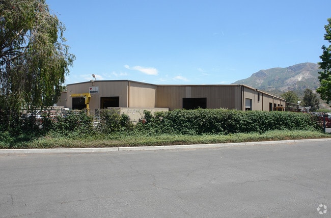
Property Record
201 Hallock Dr, Santa Paula, CA 93060


Save to a Folder
{{folder.Name}}
{{folder.ListingIds.length}} Properties
{{folder.ListingIds.length}} Property
Create a New Folder
Property Detail
201 Hallock Dr
107-0-043-035
LOT: 3 REF: 30 PM 99
Lightindustrial
Ventura
M-1
California
C and X Area of minimal flood hazard, usually depicted on FIRMs as above the 500-year flood level.
3
2025
8.68 AC
2026
Central Ventura
000500
Los Angeles
36,278 SF
Oxnard-Thousand Oaks-Ventura, CA
NEARBY LISTINGS FOR SALE OR LEASE
DEMOGRAPHICS near 201 Hallock Dr
1 mile
3 mile
5 mile
2025 Total Population
3,424
30,283
33,567
2030 Population
3,542
30,299
33,628
Pop Growth 2025-2030
+ 3.45%
+ 0.05%
+ 0.18%
Average Age
38
38
38
2025 Total Households
976
8,738
9,792
HH Growth 2025-2030
+ 4.00%
(0.02%)
+ 0.12%
Median Household Inc
$96,805
$79,035
$81,496
Avg Household Size
3.40
3.40
3.40
2025 Avg HH Vehicles
2.00
2.00
2.00
Median Home Value
$688,144
$656,903
$657,500
Median Year Built
1977
1967
1967
Nearby Places
Map Layers
Map Styles
 Street
 Aerial
Layers
 Traffic
 Biking
Places
Listings with unknown addresses are not visible on the map
- Restaurants
- Banks
- Shops
- Fitness
- Groceries
SALE & LEASE HISTORY
LISTING DATE
SALE/LEASE

Nov 08, 2017
For Sale
Aug 16, 2017
For Sale
Nearby Properties
Address
Land Use
TOTAL SIZE
Lot Size
Zoning
Address
Land Use
TOTAL SIZE
Lot Size
Zoning
15.99 AC
Address
Land Use
TOTAL SIZE
Lot Size
Zoning
Address
Land Use
TOTAL SIZE
Lot Size
Zoning
87,287 SF
5.86 AC
Address
Land Use
TOTAL SIZE
Lot Size
Zoning
479,160 SF
11.28 AC
AE
Address
Land Use
TOTAL SIZE
Lot Size
Zoning
7.58 AC
Address
Land Use
TOTAL SIZE
Lot Size
Zoning
105,773 SF
3.70 AC
M1
Address
Land Use
TOTAL SIZE
Lot Size
Zoning
41,050 SF
3.32 AC
MULT
Address
Land Use
TOTAL SIZE
Lot Size
Zoning
11.01 AC
M2
Address
Land Use
TOTAL SIZE
Lot Size
Zoning
6.32 AC
Address
Land Use
TOTAL SIZE
Lot Size
Zoning
156.10 AC
AE
Address
Land Use
TOTAL SIZE
Lot Size
Zoning
64,759 SF
4.01 AC
Address
Land Use
TOTAL SIZE
Lot Size
Zoning
24,660 SF
1.64 AC
Address
Land Use
TOTAL SIZE
Lot Size
Zoning
84.94 AC
RA
Address
Land Use
TOTAL SIZE
Lot Size
Zoning
50.49 AC
Address
Land Use
TOTAL SIZE
Lot Size
Zoning
31,852 SF
2.46 AC
C1PD
Address
Land Use
TOTAL SIZE
Lot Size
Zoning
36,096 SF
5.74 AC
M1L
Address
Land Use
TOTAL SIZE
Lot Size
Zoning
23,591 SF
0.94 AC
Address
Land Use
TOTAL SIZE
Lot Size
Zoning
18,338 SF
0.97 AC
C2
Address
Land Use
TOTAL SIZE
Lot Size
Zoning
26,228 SF
1.08 AC
Address
Land Use
TOTAL SIZE
Lot Size
Zoning
21,406 SF
6.01 AC
M1L
Address
Land Use
TOTAL SIZE
Lot Size
Zoning
2,562 SF
1.53 AC
M1
Address
Land Use
TOTAL SIZE
Lot Size
Zoning
66,439 SF
3.50 AC
Address
Land Use
TOTAL SIZE
Lot Size
Zoning
2,513 SF
38.64 AC
AE
Address
Land Use
TOTAL SIZE
Lot Size
Zoning
21,600 SF
0.96 AC
C1
Address
Land Use
TOTAL SIZE
Lot Size
Zoning
The World's #1 Commercial Real Estate Marketplace
Connect with us
© 2026 CoStar Group
The information above has been obtained from sources believed reliable. While we do not doubt its accuracy we have not verified it and make no guarantee, warranty or representation about it. It is your responsibility to independently confirm its accuracy and completeness. Any projections, opinions, assumptions, or estimates used are for example only and do not represent the current or future performance of the property. The value of this transaction to you depends on tax and other factors which should be evaluated by your tax, financial, and legal advisors. You and your advisors should conduct a careful, independent investigation of the property to determine to your satisfaction the suitability of the property for your needs.