Property Record
201 Hanover Pike, Hampstead, MD 21074
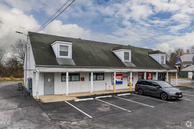

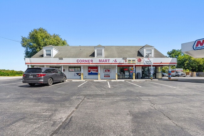
Property Detail
201 Hanover Pike
08-025770
LT - 32385 SF 201 HANOVER PIKE SE OF HAMPSTEAD
Apartment
Carroll
C-2
Maryland
B and X Area of moderate flood hazard, usually the area between the limits of the 100-year and 500-year floods.
0.74 AC
2025
Carroll County
2025
Baltimore
508103
Baltimore-Columbia-Towson, MD
2,356 SF
NEARBY LISTINGS FOR SALE OR LEASE
DEMOGRAPHICS near 201 Hanover Pike
1 mile
3 mile
5 mile
2025 Total Population
929
11,619
22,467
2030 Population
941
11,784
22,735
Pop Growth 2025-2030
+ 1.29%
+ 1.42%
+ 1.19%
Average Age
39
41
42
2025 Total Households
348
4,483
8,506
HH Growth 2025-2030
+ 1.15%
+ 1.45%
+ 1.19%
Median Household Inc
$93,269
$102,299
$105,677
Avg Household Size
2.60
2.60
2.60
2025 Avg HH Vehicles
2.00
2.00
2.00
Median Home Value
$357,236
$373,170
$398,968
Median Year Built
1986
1984
1981
Nearby Places
Map Layers
Map Styles
 Street
 Aerial
Transit
 Traffic
 Biking
Places
Listings with unknown addresses are not visible on the map
- Restaurants
- Banks
- Shops
- Fitness
- Groceries
PUBLIC TRANSPORTATION
AIRPORT
Baltimore/Washington International Thurgood Marshall
Drive
Walk
Distance
Baltimore/Washington International Thurgood Marshall
49 min
32.6 mi
Freight Ports
Port of Baltimore
Drive
Walk
Distance
Port of Baltimore
48 min
32.3 mi
SALE & LEASE HISTORY
LISTING DATE
SALE/LEASE

Sep 25, 2016
For Lease
Sep 13, 2024
For Sale
Nearby Properties
Address
Land Use
TOTAL SIZE
Lot Size
Zoning
Address
Land Use
TOTAL SIZE
Lot Size
Zoning
1,034,020 SF
51.58 AC
I-1
Address
Land Use
TOTAL SIZE
Lot Size
Zoning
842,295 SF
134.68 AC
RESTR
Address
Land Use
TOTAL SIZE
Lot Size
Zoning
223,105 SF
21.16 AC
RESTR
Address
Land Use
TOTAL SIZE
Lot Size
Zoning
115,358 SF
26.99 AC
PUBLI
Address
Land Use
TOTAL SIZE
Lot Size
Zoning
58,095 SF
19.95 AC
Address
Land Use
TOTAL SIZE
Lot Size
Zoning
95,786 SF
10.11 AC
RESTR
Address
Land Use
TOTAL SIZE
Lot Size
Zoning
52,728 SF
13.88 AC
GENER
Address
Land Use
TOTAL SIZE
Lot Size
Zoning
210,288 SF
38.44 AC
RESTR
Address
Land Use
TOTAL SIZE
Lot Size
Zoning
39,992 SF
19.57 AC
PUBLI
Address
Land Use
TOTAL SIZE
Lot Size
Zoning
13,120 SF
3.15 AC
Address
Land Use
TOTAL SIZE
Lot Size
Zoning
34,584 SF
6.02 AC
RESTR
Address
Land Use
TOTAL SIZE
Lot Size
Zoning
72,750 SF
7.09 AC
RESTR
Address
Land Use
TOTAL SIZE
Lot Size
Zoning
10,642 SF
2.30 AC
LOCAL
Address
Land Use
TOTAL SIZE
Lot Size
Zoning
7,696 SF
2.84 AC
GENER
Address
Land Use
TOTAL SIZE
Lot Size
Zoning
20,705 SF
182.66 AC
RC2
Address
Land Use
TOTAL SIZE
Lot Size
Zoning
260,550 SF
49.38 AC
HISTO
Address
Land Use
TOTAL SIZE
Lot Size
Zoning
11,860 SF
1.64 AC
LOCAL
Address
Land Use
TOTAL SIZE
Lot Size
Zoning
3,820 SF
103 AC
R-750
Address
Land Use
TOTAL SIZE
Lot Size
Zoning
39.19 AC
RESTR
Address
Land Use
TOTAL SIZE
Lot Size
Zoning
13,657 SF
4.05 AC
PRIVA
Address
Land Use
TOTAL SIZE
Lot Size
Zoning
33,350 SF
3.50 AC
HISTO
Address
Land Use
TOTAL SIZE
Lot Size
Zoning
3,864 SF
4.87 AC
C-2
Address
Land Use
TOTAL SIZE
Lot Size
Zoning
9,100 SF
0.85 AC
GENER
Address
Land Use
TOTAL SIZE
Lot Size
Zoning
2,120 SF
1.10 AC
RES O
Address
Land Use
TOTAL SIZE
Lot Size
Zoning
1,892 SF
36.10 AC
RESTR
Address
Land Use
TOTAL SIZE
Lot Size
Zoning
71.35 AC
R-100
Address
Land Use
TOTAL SIZE
Lot Size
Zoning
7,372 SF
2.55 AC
R-100
Address
Land Use
TOTAL SIZE
Lot Size
Zoning
3,496 SF
2.95 AC
BL
Address
Land Use
TOTAL SIZE
Lot Size
Zoning
9,600 SF
16.71 AC
AGRIC
Address
Land Use
TOTAL SIZE
Lot Size
Zoning
3,008 SF
0.69 AC
HISTO
The World's #1 Commercial Real Estate Marketplace
Connect with us
© 2026 CoStar Group
The information above has been obtained from sources believed reliable. While we do not doubt its accuracy we have not verified it and make no guarantee, warranty or representation about it. It is your responsibility to independently confirm its accuracy and completeness. Any projections, opinions, assumptions, or estimates used are for example only and do not represent the current or future performance of the property. The value of this transaction to you depends on tax and other factors which should be evaluated by your tax, financial, and legal advisors. You and your advisors should conduct a careful, independent investigation of the property to determine to your satisfaction the suitability of the property for your needs.