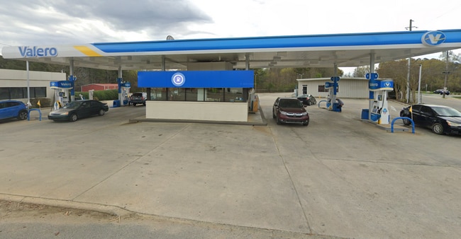
Property Record
201 Highway 158 E, Littleton, NC 27850

NEARBY LISTINGS FOR SALE OR LEASE
Property Detail
201 Highway 158 E
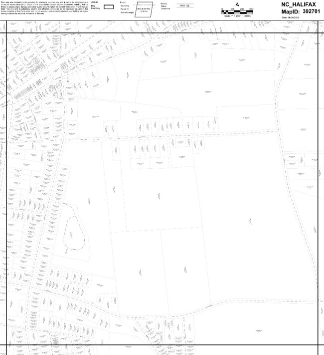
07-00064
Southgate Subdivision
Commercialnec
SOUTH MAIN 8TH CR FERGUSN
X
Halifax
3720392600J
North Carolina
2024
0.26 AC
2025
North Carolina Northeast Area
930702
Other Market Areas
1,104 SF
Roanoke Rapids, NC
DEMOGRAPHICS near 201 Highway 158 E
1 Mile
3 Mile
5 Mile
2024 Total Population
719
1,474
3,313
2029 Population
698
1,460
3,388
Pop Growth 2024-2029
(2.92%)
(0.95%)
+ 2.26%
Average Age
46
47
50
2024 Total Households
343
694
1,578
HH Growth 2024-2029
(2.92%)
(0.86%)
+ 2.41%
Median Household Inc
$23,199
$30,956
$47,548
Avg Household Size
2.10
2.10
2.10
2024 Avg HH Vehicles
2.00
2.00
2.00
Median Home Value
$117,910
$121,901
$192,985
Median Year Built
1973
1984
1988
Nearby Places
Map Layers
Map Styles
 Street
 Aerial
- Restaurants
- Banks
- Shops
- Fitness
- Groceries
Nearby Properties
Address
Land Use
TOTAL SIZE
Lot Size
Zoning
Address
Land Use
TOTAL SIZE
Lot Size
Zoning
23,078 SF
4.22 AC
LITRS
Address
Land Use
TOTAL SIZE
Lot Size
Zoning
32,044 SF
12.50 AC
LITRS
Address
Land Use
TOTAL SIZE
Lot Size
Zoning
5,486 SF
8.97 AC
Address
Land Use
TOTAL SIZE
Lot Size
Zoning
0.38 AC
LITC
Address
Land Use
TOTAL SIZE
Lot Size
Zoning
7,560 SF
8.71 AC
LITRS
Address
Land Use
TOTAL SIZE
Lot Size
Zoning
916 SF
3.46 AC
Address
Land Use
TOTAL SIZE
Lot Size
Zoning
4,970 SF
4.32 AC
Address
Land Use
TOTAL SIZE
Lot Size
Zoning
12,708 SF
7.80 AC
LITC
Address
Land Use
TOTAL SIZE
Lot Size
Zoning
50,260 SF
7.62 AC
LITRS
Address
Land Use
TOTAL SIZE
Lot Size
Zoning
6,710 SF
0.58 AC
Address
Land Use
TOTAL SIZE
Lot Size
Zoning
9,585 SF
1.65 AC
LITC
Address
Land Use
TOTAL SIZE
Lot Size
Zoning
1,584 SF
2.37 AC
LITRS
Address
Land Use
TOTAL SIZE
Lot Size
Zoning
26.50 AC
Address
Land Use
TOTAL SIZE
Lot Size
Zoning
15,600 SF
2.04 AC
LITC
Address
Land Use
TOTAL SIZE
Lot Size
Zoning
8,796 SF
0.74 AC
LITC
Address
Land Use
TOTAL SIZE
Lot Size
Zoning
8,198 SF
0.33 AC
LITRS
Address
Land Use
TOTAL SIZE
Lot Size
Zoning
14,612 SF
8 AC
LITRA
Address
Land Use
TOTAL SIZE
Lot Size
Zoning
7,908 SF
1.64 AC
LITRS
Address
Land Use
TOTAL SIZE
Lot Size
Zoning
Address
Land Use
TOTAL SIZE
Lot Size
Zoning
5,131 SF
0.36 AC
LITC
Address
Land Use
TOTAL SIZE
Lot Size
Zoning
Address
Land Use
TOTAL SIZE
Lot Size
Zoning
Address
Land Use
TOTAL SIZE
Lot Size
Zoning
Address
Land Use
TOTAL SIZE
Lot Size
Zoning
Address
Land Use
TOTAL SIZE
Lot Size
Zoning
Address
Land Use
TOTAL SIZE
Lot Size
Zoning
10.10 AC
Address
Land Use
TOTAL SIZE
Lot Size
Zoning
1.52 AC
Address
Land Use
TOTAL SIZE
Lot Size
Zoning
Address
Land Use
TOTAL SIZE
Lot Size
Zoning
8,415 SF
1.25 AC
LITRMH
Address
Land Use
TOTAL SIZE
Lot Size
Zoning
1.92 AC
The World's #1 Commercial Real Estate Marketplace
Connect with us
© 2025 CoStar Group
The information above has been obtained from sources believed reliable. While we do not doubt its accuracy we have not verified it and make no guarantee, warranty or representation about it. It is your responsibility to independently confirm its accuracy and completeness. Any projections, opinions, assumptions, or estimates used are for example only and do not represent the current or future performance of the property. The value of this transaction to you depends on tax and other factors which should be evaluated by your tax, financial, and legal advisors. You and your advisors should conduct a careful, independent investigation of the property to determine to your satisfaction the suitability of the property for your needs.