Property Record
201 Hillsboro St, Oxford, NC 27565


NEARBY LISTINGS FOR SALE OR LEASE
-
-
View all Oxford listings for sale on LoopNet.com
Property Detail
201 Hillsboro St
192317014917
Survey For Adp Oxford
Storebuilding
201 HILLSBORO ST - WALGREENS
X
Granville
3720192300K
North Carolina
2025
2 AC
2025
North Carolina Northeast Area
970400
Other Market Areas
14,736 SF
Oxford, NC
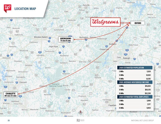
DEMOGRAPHICS near 201 Hillsboro St
1 Mile
3 Mile
5 Mile
2024 Total Population
6,286
11,540
15,133
2029 Population
6,658
12,181
15,965
Pop Growth 2024-2029
+ 5.92%
+ 5.55%
+ 5.50%
Average Age
41
42
42
2024 Total Households
2,618
4,705
6,100
HH Growth 2024-2029
+ 5.77%
+ 5.42%
+ 5.34%
Median Household Inc
$34,673
$46,520
$49,987
Avg Household Size
2.30
2.30
2.40
2024 Avg HH Vehicles
2.00
2.00
2.00
Median Home Value
$162,718
$174,643
$181,836
Median Year Built
1970
1973
1976
Nearby Places
Map Layers
Map Styles
 Street
 Aerial
- Restaurants
- Banks
- Shops
- Fitness
- Groceries
PUBLIC TRANSPORTATION
AIRPORT
Raleigh-Durham International
DRIVE
WALK
Distance
Raleigh-Durham International
52 min
39.2 mi
SALE & LEASE HISTORY
LISTING DATE
SALE/LEASE

Sep 18, 2018
For Sale
May 09, 2019
For Sale
May 07, 2019
For Sale
May 06, 2020
For Sale
Mar 28, 2017
For Sale
Nearby Properties
Address
Land Use
TOTAL SIZE
Lot Size
Zoning
Address
Land Use
TOTAL SIZE
Lot Size
Zoning
433,560 SF
122.96 AC
I1
Address
Land Use
TOTAL SIZE
Lot Size
Zoning
25,364 SF
266.74 AC
RAR6
Address
Land Use
TOTAL SIZE
Lot Size
Zoning
111,264 SF
5.81 AC
OI
Address
Land Use
TOTAL SIZE
Lot Size
Zoning
144,698 SF
42.10 AC
RA
Address
Land Use
TOTAL SIZE
Lot Size
Zoning
110,126 SF
40 AC
Address
Land Use
TOTAL SIZE
Lot Size
Zoning
149,950 SF
29.95 AC
B2
Address
Land Use
TOTAL SIZE
Lot Size
Zoning
65,740 SF
37.29 AC
RA
Address
Land Use
TOTAL SIZE
Lot Size
Zoning
8,352 SF
110.84 AC
I2
Address
Land Use
TOTAL SIZE
Lot Size
Zoning
8,640 SF
13.13 AC
Address
Land Use
TOTAL SIZE
Lot Size
Zoning
9,000 SF
36.08 AC
Address
Land Use
TOTAL SIZE
Lot Size
Zoning
14,634 SF
11.97 AC
B1
Address
Land Use
TOTAL SIZE
Lot Size
Zoning
5,294 SF
19.44 AC
B1
Address
Land Use
TOTAL SIZE
Lot Size
Zoning
15,346 SF
5.87 AC
I2
Address
Land Use
TOTAL SIZE
Lot Size
Zoning
186,443 SF
6 AC
I2
Address
Land Use
TOTAL SIZE
Lot Size
Zoning
88,275 SF
15.56 AC
I2AR40
Address
Land Use
TOTAL SIZE
Lot Size
Zoning
176,080 SF
8.32 AC
Address
Land Use
TOTAL SIZE
Lot Size
Zoning
33,547 SF
10.03 AC
Address
Land Use
TOTAL SIZE
Lot Size
Zoning
39,844 SF
5.91 AC
B
Address
Land Use
TOTAL SIZE
Lot Size
Zoning
1,760 SF
9.91 AC
RA
Address
Land Use
TOTAL SIZE
Lot Size
Zoning
34,972 SF
19.19 AC
B1
Address
Land Use
TOTAL SIZE
Lot Size
Zoning
37,999 SF
10.29 AC
Address
Land Use
TOTAL SIZE
Lot Size
Zoning
42,806 SF
0.96 AC
B1
Address
Land Use
TOTAL SIZE
Lot Size
Zoning
161,949 SF
69.03 AC
I2
Address
Land Use
TOTAL SIZE
Lot Size
Zoning
133,676 SF
11 AC
Address
Land Use
TOTAL SIZE
Lot Size
Zoning
2,812 SF
8.37 AC
Address
Land Use
TOTAL SIZE
Lot Size
Zoning
18,729 SF
6.66 AC
B1
Address
Land Use
TOTAL SIZE
Lot Size
Zoning
129,168 SF
29.26 AC
I1
Address
Land Use
TOTAL SIZE
Lot Size
Zoning
1,454 SF
12.25 AC
R6
Address
Land Use
TOTAL SIZE
Lot Size
Zoning
70,040 SF
15.32 AC
B2
Address
Land Use
TOTAL SIZE
Lot Size
Zoning
41,289 SF
16 AC
AR40
The World's #1 Commercial Real Estate Marketplace
Connect with us
© 2025 CoStar Group
The information above has been obtained from sources believed reliable. While we do not doubt its accuracy we have not verified it and make no guarantee, warranty or representation about it. It is your responsibility to independently confirm its accuracy and completeness. Any projections, opinions, assumptions, or estimates used are for example only and do not represent the current or future performance of the property. The value of this transaction to you depends on tax and other factors which should be evaluated by your tax, financial, and legal advisors. You and your advisors should conduct a careful, independent investigation of the property to determine to your satisfaction the suitability of the property for your needs.