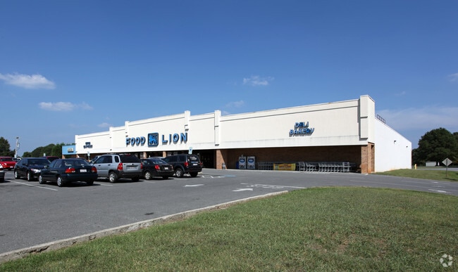
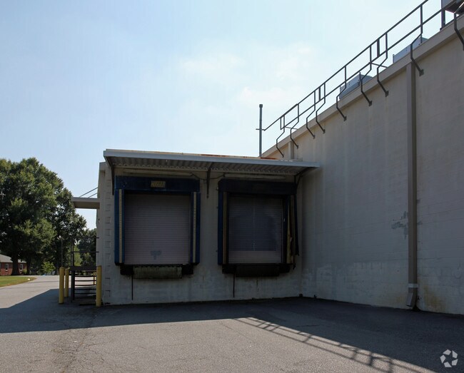
Property Record
201 Island Ford Rd, Maiden, NC 28650


NEARBY LISTINGS FOR SALE OR LEASE
-
-
View all Maiden listings for sale on LoopNet.com
Property Detail
201 Island Ford Rd
3646087871740000
PLAT 10-42
Stripcommercialcenter
Catawba
X
North Carolina
3710364600J
4.54 AC
2024
Catawba County
2025
Charlotte
011602
Hickory-Lenoir-Morganton, NC
42,844 SF
DEMOGRAPHICS near 201 Island Ford Rd
1 Mile
3 Mile
5 Mile
2024 Total Population
2,330
10,438
24,990
2029 Population
2,441
11,304
27,504
Pop Growth 2024-2029
+ 4.76%
+ 8.30%
+ 10.06%
Average Age
40
41
41
2024 Total Households
926
4,045
9,620
HH Growth 2024-2029
+ 4.64%
+ 8.36%
+ 10.24%
Median Household Inc
$63,716
$62,415
$65,843
Avg Household Size
2.50
2.50
2.50
2024 Avg HH Vehicles
2.00
2.00
2.00
Median Home Value
$170,803
$178,612
$185,543
Median Year Built
1983
1986
1988
Nearby Places
Map Layers
Map Styles
 Street
 Aerial
- Restaurants
- Banks
- Shops
- Fitness
- Groceries
PUBLIC TRANSPORTATION
AIRPORT
Charlotte/Douglas International
DRIVE
WALK
Distance
Charlotte/Douglas International
57 min
38.4 mi
Concord-Padgett Regional
DRIVE
WALK
Distance
Concord-Padgett Regional
58 min
42.5 mi
Freight Ports
North Charleston Terminal
DRIVE
WALK
Distance
North Charleston Terminal
269 min
232.9 mi
Nearby Properties
Address
Land Use
TOTAL SIZE
Lot Size
Zoning
Address
Land Use
TOTAL SIZE
Lot Size
Zoning
999,249 SF
81.97 AC
I-G
Address
Land Use
TOTAL SIZE
Lot Size
Zoning
404,200 SF
44.83 AC
I-G
Address
Land Use
TOTAL SIZE
Lot Size
Zoning
362,664 SF
48.66 AC
I-G
Address
Land Use
TOTAL SIZE
Lot Size
Zoning
385,000 SF
33.43 AC
I-G
Address
Land Use
TOTAL SIZE
Lot Size
Zoning
415,540 SF
29.21 AC
I-G
Address
Land Use
TOTAL SIZE
Lot Size
Zoning
62.82 AC
R-20
Address
Land Use
TOTAL SIZE
Lot Size
Zoning
316,596 SF
23.76 AC
I-G
Address
Land Use
TOTAL SIZE
Lot Size
Zoning
279,874 SF
30.15 AC
I-G
Address
Land Use
TOTAL SIZE
Lot Size
Zoning
307,200 SF
35.25 AC
I-G
Address
Land Use
TOTAL SIZE
Lot Size
Zoning
272,580 SF
22.64 AC
I-G
Address
Land Use
TOTAL SIZE
Lot Size
Zoning
91,872 SF
15.67 AC
R-15
Address
Land Use
TOTAL SIZE
Lot Size
Zoning
220,808 SF
30.48 AC
I-G
Address
Land Use
TOTAL SIZE
Lot Size
Zoning
120,010 SF
73.15 AC
R-20
Address
Land Use
TOTAL SIZE
Lot Size
Zoning
174,720 SF
24.81 AC
I-G
Address
Land Use
TOTAL SIZE
Lot Size
Zoning
259,556 SF
19.80 AC
M-1
Address
Land Use
TOTAL SIZE
Lot Size
Zoning
148,421 SF
14.44 AC
I-G
Address
Land Use
TOTAL SIZE
Lot Size
Zoning
105,148 SF
12.53 AC
I-G
Address
Land Use
TOTAL SIZE
Lot Size
Zoning
119,354 SF
20.15 AC
I-G
Address
Land Use
TOTAL SIZE
Lot Size
Zoning
192,292 SF
19.81 AC
M-1
Address
Land Use
TOTAL SIZE
Lot Size
Zoning
20.93 AC
R-15
Address
Land Use
TOTAL SIZE
Lot Size
Zoning
19.41 AC
R-40
Address
Land Use
TOTAL SIZE
Lot Size
Zoning
90,009 SF
9.59 AC
I-G
Address
Land Use
TOTAL SIZE
Lot Size
Zoning
93,284 SF
10.67 AC
C-2
Address
Land Use
TOTAL SIZE
Lot Size
Zoning
76,742 SF
7.12 AC
I-G
Address
Land Use
TOTAL SIZE
Lot Size
Zoning
60,606 SF
8.54 AC
I-G
Address
Land Use
TOTAL SIZE
Lot Size
Zoning
33.07 AC
R-11
Address
Land Use
TOTAL SIZE
Lot Size
Zoning
45,000 SF
11.38 AC
I-G
Address
Land Use
TOTAL SIZE
Lot Size
Zoning
90,023 SF
16.95 AC
M-1
Address
Land Use
TOTAL SIZE
Lot Size
Zoning
38,400 SF
5.15 AC
I-G
Address
Land Use
TOTAL SIZE
Lot Size
Zoning
137,440 SF
15.12 AC
M-1
The World's #1 Commercial Real Estate Marketplace
Connect with us
© 2026 CoStar Group
The information above has been obtained from sources believed reliable. While we do not doubt its accuracy we have not verified it and make no guarantee, warranty or representation about it. It is your responsibility to independently confirm its accuracy and completeness. Any projections, opinions, assumptions, or estimates used are for example only and do not represent the current or future performance of the property. The value of this transaction to you depends on tax and other factors which should be evaluated by your tax, financial, and legal advisors. You and your advisors should conduct a careful, independent investigation of the property to determine to your satisfaction the suitability of the property for your needs.