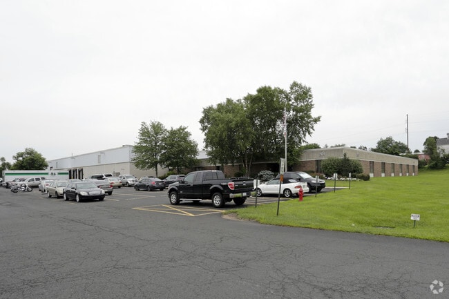
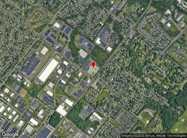
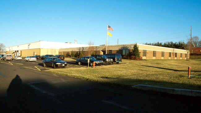
Property Record
201 Ivyland Rd, Warminster, PA 18974
NEARBY LISTINGS FOR SALE OR LEASE
Property Detail
201 Ivyland Rd
17-001-001
Benjamin Brodsky
Warehouse
18.210A W S T334 130 FT N GREELEY AVE
X
Bucks
42017C0404J
Pennsylvania
2024
18.21 AC
2025
Bucks
106202
Philadelphia
100,522 SF
Philadelphia-Camden-Wilmington, PA-NJ-DE-MD
DEMOGRAPHICS near 201 Ivyland Rd
1 Mile
3 Mile
5 Mile
2024 Total Population
6,786
76,984
162,149
2029 Population
6,791
77,672
163,620
Pop Growth 2024-2029
+ 0.07%
+ 0.89%
+ 0.91%
Average Age
54
45
43
2024 Total Households
3,200
30,558
62,305
HH Growth 2024-2029
(0.16%)
+ 1.04%
+ 1.04%
Median Household Inc
$87,401
$92,439
$99,346
Avg Household Size
2.10
2.40
2.50
2024 Avg HH Vehicles
2.00
2.00
2.00
Median Home Value
$363,210
$364,918
$386,567
Median Year Built
1994
1972
1973
Nearby Places
- Restaurants
- Banks
- Shops
- Fitness
- Groceries
PUBLIC TRANSPORTATION
COMMUTER RAIL
Warminster (R2 - Southeastern Pennsylvania Transportation Authority Regional Rail (SEPTA Regional Rail))
DRIVE
WALK
Distance
Warminster (R2 - Southeastern Pennsylvania Transportation Authority Regional Rail (SEPTA Regional Rail))
5 min
1.4 mi
Hatboro (R2 - Southeastern Pennsylvania Transportation Authority Regional Rail (SEPTA Regional Rail))
DRIVE
WALK
Distance
Hatboro (R2 - Southeastern Pennsylvania Transportation Authority Regional Rail (SEPTA Regional Rail))
7 min
3.1 mi
AIRPORT
Trenton Mercer
DRIVE
WALK
Distance
Trenton Mercer
34 min
19.2 mi
Philadelphia International
DRIVE
WALK
Distance
Philadelphia International
58 min
33.4 mi
Nearby Properties
Address
Land Use
TOTAL SIZE
Lot Size
Zoning
Address
Land Use
TOTAL SIZE
Lot Size
Zoning
377,044 SF
58.73 AC
INST
Address
Land Use
TOTAL SIZE
Lot Size
Zoning
571,213 SF
67.31 AC
M
Address
Land Use
TOTAL SIZE
Lot Size
Zoning
251,655 SF
48.95 AC
SC
Address
Land Use
TOTAL SIZE
Lot Size
Zoning
256,679 SF
14 AC
MI
Address
Land Use
TOTAL SIZE
Lot Size
Zoning
420,736 SF
29.47 AC
LI
Address
Land Use
TOTAL SIZE
Lot Size
Zoning
110,198 SF
12.18 AC
R2
Address
Land Use
TOTAL SIZE
Lot Size
Zoning
182,364 SF
21.06 AC
M
Address
Land Use
TOTAL SIZE
Lot Size
Zoning
240,682 SF
4.81 AC
HI
Address
Land Use
TOTAL SIZE
Lot Size
Zoning
60,945 SF
74.12 AC
Address
Land Use
TOTAL SIZE
Lot Size
Zoning
125,387 SF
4.10 AC
RC2
Address
Land Use
TOTAL SIZE
Lot Size
Zoning
162,363 SF
2.72 AC
HI
Address
Land Use
TOTAL SIZE
Lot Size
Zoning
91,446 SF
2.53 AC
R7
Address
Land Use
TOTAL SIZE
Lot Size
Zoning
269,481 SF
23.79 AC
SC1
Address
Land Use
TOTAL SIZE
Lot Size
Zoning
257,048 SF
36.13 AC
C
Address
Land Use
TOTAL SIZE
Lot Size
Zoning
74,764 SF
10.17 AC
SC
Address
Land Use
TOTAL SIZE
Lot Size
Zoning
58,318 SF
20.12 AC
R4
Address
Land Use
TOTAL SIZE
Lot Size
Zoning
29,308 SF
15.96 AC
I
Address
Land Use
TOTAL SIZE
Lot Size
Zoning
87,120 SF
1.51 AC
RC2
Address
Land Use
TOTAL SIZE
Lot Size
Zoning
72,852 SF
21.24 AC
R2
Address
Land Use
TOTAL SIZE
Lot Size
Zoning
59,133 SF
6.67 AC
LC3
Address
Land Use
TOTAL SIZE
Lot Size
Zoning
56,668 SF
3.68 AC
R4
Address
Land Use
TOTAL SIZE
Lot Size
Zoning
25,572 SF
3.42 AC
R2
Address
Land Use
TOTAL SIZE
Lot Size
Zoning
37,806 SF
21.50 AC
R5
Address
Land Use
TOTAL SIZE
Lot Size
Zoning
25,021 SF
10.82 AC
I
Address
Land Use
TOTAL SIZE
Lot Size
Zoning
249,396 SF
18.70 AC
I
Address
Land Use
TOTAL SIZE
Lot Size
Zoning
9,999 SF
2.55 AC
INST
Address
Land Use
TOTAL SIZE
Lot Size
Zoning
40,797 SF
2.08 AC
HB
Address
Land Use
TOTAL SIZE
Lot Size
Zoning
10,000 SF
10.54 AC
MF1
Address
Land Use
TOTAL SIZE
Lot Size
Zoning
140,444 SF
15.31 AC
I
Address
Land Use
TOTAL SIZE
Lot Size
Zoning
73,663 SF
14.84 AC
MF-1
The World's #1 Commercial Real Estate Marketplace
Connect with us
© 2025 CoStar Group
The information above has been obtained from sources believed reliable. While we do not doubt its accuracy we have not verified it and make no guarantee, warranty or representation about it. It is your responsibility to independently confirm its accuracy and completeness. Any projections, opinions, assumptions, or estimates used are for example only and do not represent the current or future performance of the property. The value of this transaction to you depends on tax and other factors which should be evaluated by your tax, financial, and legal advisors. You and your advisors should conduct a careful, independent investigation of the property to determine to your satisfaction the suitability of the property for your needs.