Property Record
201 Love Rd, Reading, PA 19607

Property Detail
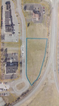
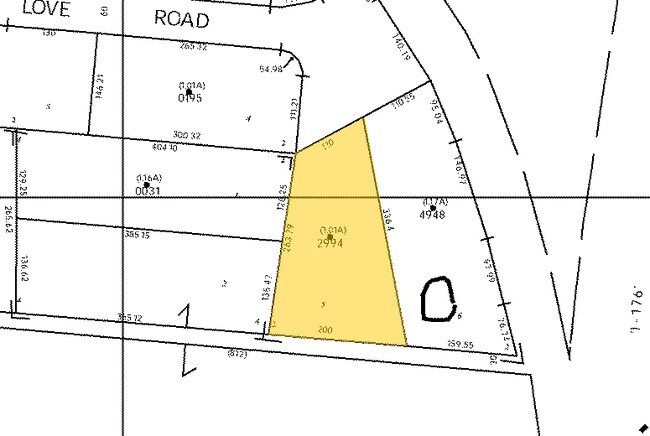
201 Love Rd
39-5314-09-15-2994
Berks
Racquetcourt
Pennsylvania
B and X Area of moderate flood hazard, usually the area between the limits of the 100-year and 500-year floods.
5
2025
1.01 AC
2025
Berks County
011603
Philadelphia
14,697 SF
Reading, PA
NEARBY LISTINGS FOR SALE OR LEASE
DEMOGRAPHICS near 201 Love Rd
1 mile
3 mile
5 mile
2025 Total Population
2,845
14,419
116,115
2030 Population
2,911
14,723
118,607
Pop Growth 2025-2030
+ 2.32%
+ 2.11%
+ 2.15%
Average Age
49
44
40
2025 Total Households
1,510
6,143
45,062
HH Growth 2025-2030
+ 2.52%
+ 2.18%
+ 2.15%
Median Household Inc
$84,316
$93,979
$66,507
Avg Household Size
1.90
2.30
2.50
2025 Avg HH Vehicles
2.00
2.00
2.00
Median Home Value
$279,463
$290,634
$232,478
Median Year Built
1979
1977
1962
Nearby Places
Map Layers
Map Styles
 Street
 Aerial
Transit
 Traffic
 Biking
Places
Listings with unknown addresses are not visible on the map
- Restaurants
- Banks
- Shops
- Fitness
- Groceries
PUBLIC TRANSPORTATION
AIRPORT
Lehigh Valley International
Drive
Walk
Distance
Lehigh Valley International
70 min
45.2 mi
Freight Ports
Port of Wilmington, RI
Drive
Walk
Distance
Port of Wilmington, RI
79 min
52.5 mi
SALE & LEASE HISTORY
LISTING DATE
SALE/LEASE

Sep 26, 2017
For Sale
Nearby Properties
Address
Land Use
TOTAL SIZE
Lot Size
Zoning
Address
Land Use
TOTAL SIZE
Lot Size
Zoning
392,251 SF
78.10 AC
Address
Land Use
TOTAL SIZE
Lot Size
Zoning
241,645 SF
37.72 AC
Address
Land Use
TOTAL SIZE
Lot Size
Zoning
20,731 SF
28.51 AC
Address
Land Use
TOTAL SIZE
Lot Size
Zoning
310,014 SF
15.02 AC
Address
Land Use
TOTAL SIZE
Lot Size
Zoning
163,466 SF
19.19 AC
Address
Land Use
TOTAL SIZE
Lot Size
Zoning
129,363 SF
12.14 AC
Address
Land Use
TOTAL SIZE
Lot Size
Zoning
84,599 SF
28.56 AC
Address
Land Use
TOTAL SIZE
Lot Size
Zoning
55,132 SF
6.64 AC
Address
Land Use
TOTAL SIZE
Lot Size
Zoning
171,219 SF
38.21 AC
Address
Land Use
TOTAL SIZE
Lot Size
Zoning
38,272 SF
16.16 AC
Address
Land Use
TOTAL SIZE
Lot Size
Zoning
135,196 SF
22.41 AC
Address
Land Use
TOTAL SIZE
Lot Size
Zoning
78,648 SF
6.73 AC
Address
Land Use
TOTAL SIZE
Lot Size
Zoning
120,390 SF
12.65 AC
Address
Land Use
TOTAL SIZE
Lot Size
Zoning
82,276 SF
11.16 AC
Address
Land Use
TOTAL SIZE
Lot Size
Zoning
84,337 SF
11.20 AC
Address
Land Use
TOTAL SIZE
Lot Size
Zoning
87,500 SF
6.68 AC
Address
Land Use
TOTAL SIZE
Lot Size
Zoning
44,227 SF
15.59 AC
Address
Land Use
TOTAL SIZE
Lot Size
Zoning
14,700 SF
6.04 AC
Address
Land Use
TOTAL SIZE
Lot Size
Zoning
8,640 SF
182.40 AC
Address
Land Use
TOTAL SIZE
Lot Size
Zoning
41,112 SF
1.16 AC
Address
Land Use
TOTAL SIZE
Lot Size
Zoning
65,353 SF
23.73 AC
Address
Land Use
TOTAL SIZE
Lot Size
Zoning
28,140 SF
208.09 AC
Address
Land Use
TOTAL SIZE
Lot Size
Zoning
35,982 SF
1.16 AC
Address
Land Use
TOTAL SIZE
Lot Size
Zoning
30,929 SF
2.54 AC
Address
Land Use
TOTAL SIZE
Lot Size
Zoning
11,194 SF
100.83 AC
Address
Land Use
TOTAL SIZE
Lot Size
Zoning
93,482 SF
13.94 AC
Address
Land Use
TOTAL SIZE
Lot Size
Zoning
30,492 SF
0.39 AC
Address
Land Use
TOTAL SIZE
Lot Size
Zoning
39,400 SF
5.31 AC
Address
Land Use
TOTAL SIZE
Lot Size
Zoning
10,548 SF
1.43 AC
Address
Land Use
TOTAL SIZE
Lot Size
Zoning
36,622 SF
6.67 AC
The World's #1 Commercial Real Estate Marketplace
Connect with us
© 2026 CoStar Group
The information above has been obtained from sources believed reliable. While we do not doubt its accuracy we have not verified it and make no guarantee, warranty or representation about it. It is your responsibility to independently confirm its accuracy and completeness. Any projections, opinions, assumptions, or estimates used are for example only and do not represent the current or future performance of the property. The value of this transaction to you depends on tax and other factors which should be evaluated by your tax, financial, and legal advisors. You and your advisors should conduct a careful, independent investigation of the property to determine to your satisfaction the suitability of the property for your needs.