Property Record
201 Main St, Delta, OH 43515

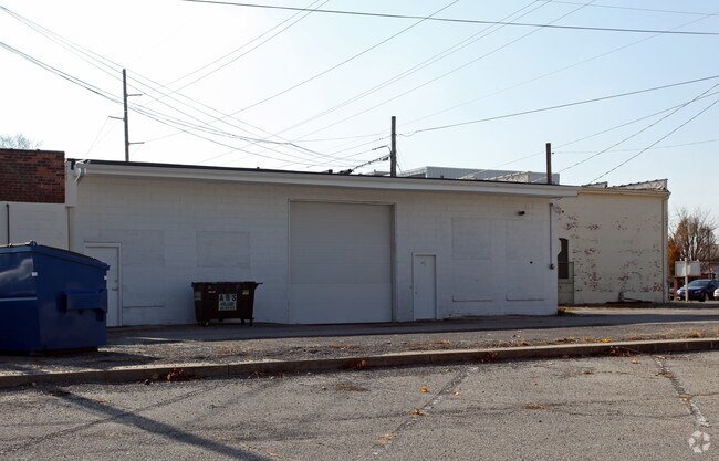
Property Detail
201 Main St
31-058460-00.000
THE HIGHLANDS LOT 4 & 5 E 6.75FT
Officebuilding
FULTON
B2
Ohio
B and X Area of moderate flood hazard, usually the area between the limits of the 100-year and 500-year floods.
4,5
2024
0.17 AC
2024
Fulton County
040400
Toledo
5,208 SF
Toledo, OH
NEARBY LISTINGS FOR SALE OR LEASE
DEMOGRAPHICS near 201 Main St
1 mile
3 mile
5 mile
2025 Total Population
3,192
4,767
8,326
2030 Population
3,200
4,768
8,284
Pop Growth 2025-2030
+ 0.25%
+ 0.02%
(0.50%)
Average Age
39
39
41
2025 Total Households
1,250
1,847
3,207
HH Growth 2025-2030
+ 0.32%
0.00%
(0.50%)
Median Household Inc
$64,115
$68,274
$75,820
Avg Household Size
2.50
2.50
2.50
2025 Avg HH Vehicles
2.00
2.00
2.00
Median Home Value
$164,147
$174,784
$195,066
Median Year Built
1962
1966
1971
Nearby Places
Map Layers
Map Styles
 Street
 Aerial
Transit
 Traffic
 Biking
Places
Listings with unknown addresses are not visible on the map
- Restaurants
- Banks
- Shops
- Fitness
- Groceries
PUBLIC TRANSPORTATION
AIRPORT
Eugene F Kranz Toledo Express
Drive
Walk
Distance
Eugene F Kranz Toledo Express
24 min
11.7 mi
Freight Ports
Port of Toledo
Drive
Walk
Distance
Port of Toledo
52 min
31.2 mi
Nearby Properties
Address
Land Use
TOTAL SIZE
Lot Size
Zoning
Address
Land Use
TOTAL SIZE
Lot Size
Zoning
70,940 SF
437.83 AC
M2
Address
Land Use
TOTAL SIZE
Lot Size
Zoning
8,060 SF
66.36 AC
Address
Land Use
TOTAL SIZE
Lot Size
Zoning
2,408 SF
291.46 AC
M3
Address
Land Use
TOTAL SIZE
Lot Size
Zoning
110,718 SF
20.17 AC
Address
Land Use
TOTAL SIZE
Lot Size
Zoning
148,684 SF
72.46 AC
M3
Address
Land Use
TOTAL SIZE
Lot Size
Zoning
14,000 SF
259.90 AC
M2
Address
Land Use
TOTAL SIZE
Lot Size
Zoning
8,000 SF
48.96 AC
S1
Address
Land Use
TOTAL SIZE
Lot Size
Zoning
70,945 SF
22.12 AC
Address
Land Use
TOTAL SIZE
Lot Size
Zoning
18,800 SF
56.86 AC
M3
Address
Land Use
TOTAL SIZE
Lot Size
Zoning
3,600 SF
14.82 AC
Address
Land Use
TOTAL SIZE
Lot Size
Zoning
2.67 AC
R1
Address
Land Use
TOTAL SIZE
Lot Size
Zoning
100,000 SF
7.68 AC
M3
Address
Land Use
TOTAL SIZE
Lot Size
Zoning
393.60 AC
Address
Land Use
TOTAL SIZE
Lot Size
Zoning
60,000 SF
5.99 AC
Address
Land Use
TOTAL SIZE
Lot Size
Zoning
106,250 SF
11.09 AC
M3
Address
Land Use
TOTAL SIZE
Lot Size
Zoning
23,877 SF
0.84 AC
R2
Address
Land Use
TOTAL SIZE
Lot Size
Zoning
1,718 SF
212.16 AC
C2
Address
Land Use
TOTAL SIZE
Lot Size
Zoning
2,192 SF
277.74 AC
Address
Land Use
TOTAL SIZE
Lot Size
Zoning
1,822 SF
319 AC
Address
Land Use
TOTAL SIZE
Lot Size
Zoning
7,330 SF
4.94 AC
M2
Address
Land Use
TOTAL SIZE
Lot Size
Zoning
1,364 SF
222.08 AC
Address
Land Use
TOTAL SIZE
Lot Size
Zoning
215.38 AC
Address
Land Use
TOTAL SIZE
Lot Size
Zoning
10,658 SF
12.92 AC
M3
Address
Land Use
TOTAL SIZE
Lot Size
Zoning
14,348 SF
5.26 AC
R2
Address
Land Use
TOTAL SIZE
Lot Size
Zoning
239.50 AC
Address
Land Use
TOTAL SIZE
Lot Size
Zoning
73.11 AC
Address
Land Use
TOTAL SIZE
Lot Size
Zoning
190.01 AC
Address
Land Use
TOTAL SIZE
Lot Size
Zoning
223.54 AC
M1
Address
Land Use
TOTAL SIZE
Lot Size
Zoning
24.61 AC
S1
Address
Land Use
TOTAL SIZE
Lot Size
Zoning
2,742 SF
157 AC
The World's #1 Commercial Real Estate Marketplace
Connect with us
© 2026 CoStar Group
The information above has been obtained from sources believed reliable. While we do not doubt its accuracy we have not verified it and make no guarantee, warranty or representation about it. It is your responsibility to independently confirm its accuracy and completeness. Any projections, opinions, assumptions, or estimates used are for example only and do not represent the current or future performance of the property. The value of this transaction to you depends on tax and other factors which should be evaluated by your tax, financial, and legal advisors. You and your advisors should conduct a careful, independent investigation of the property to determine to your satisfaction the suitability of the property for your needs.