Property Record
201 Main St, Vacaville, CA 95688
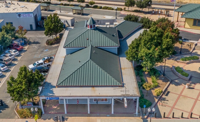


Property Detail
201 Main St
Vallejo, CA
BK-BG 00-00
0032-051-090
Solano
Storebuilding
California
AE The base floodplain where base flood elevations are provided. AE Zones are now used on new format FIRMs instead of A1-A30 Zones.
6,7
2024
0.23 AC
2025
Fairfield
253203
North Bay/Santa Rosa
5,593 SF
NEARBY LISTINGS FOR SALE OR LEASE
DEMOGRAPHICS near 201 Main St
1 mile
3 mile
5 mile
2025 Total Population
13,800
93,624
122,735
2030 Population
13,907
94,105
123,645
Pop Growth 2025-2030
+ 0.78%
+ 0.51%
+ 0.74%
Average Age
38
39
39
2025 Total Households
4,573
30,766
40,640
HH Growth 2025-2030
+ 0.81%
+ 0.52%
+ 0.74%
Median Household Inc
$61,443
$86,141
$96,674
Avg Household Size
2.90
3.00
2.90
2025 Avg HH Vehicles
2.00
2.00
2.00
Median Home Value
$463,272
$589,773
$650,759
Median Year Built
1970
1978
1982
Nearby Places
Map Layers
Map Styles
 Street
 Aerial
Layers
 Traffic
 Biking
Places
Listings with unknown addresses are not visible on the map
- Restaurants
- Banks
- Shops
- Fitness
- Groceries
PUBLIC TRANSPORTATION
COMMUTER RAIL
Fairfield-Vacaville Amtrak Station (Capitol Corridor - Amtrak)
Drive
Walk
Distance
Fairfield-Vacaville Amtrak Station (Capitol Corridor - Amtrak)
11 min
6.0 mi
Freight Ports
Port of Richmond
Drive
Walk
Distance
Port of Richmond
57 min
43.6 mi
SALE & LEASE HISTORY
LISTING DATE
SALE/LEASE

Oct 24, 2023
For Sale
Nearby Properties
Address
Land Use
TOTAL SIZE
Lot Size
Zoning
Address
Land Use
TOTAL SIZE
Lot Size
Zoning
12.64 AC
Address
Land Use
TOTAL SIZE
Lot Size
Zoning
332,833 SF
18.53 AC
Address
Land Use
TOTAL SIZE
Lot Size
Zoning
104,468 SF
1.30 AC
Address
Land Use
TOTAL SIZE
Lot Size
Zoning
210,900 SF
26.31 AC
Address
Land Use
TOTAL SIZE
Lot Size
Zoning
151,756 SF
10.07 AC
Address
Land Use
TOTAL SIZE
Lot Size
Zoning
159,056 SF
11.07 AC
Address
Land Use
TOTAL SIZE
Lot Size
Zoning
7.69 AC
Address
Land Use
TOTAL SIZE
Lot Size
Zoning
224,536 SF
11.77 AC
CG W/RES O
Address
Land Use
TOTAL SIZE
Lot Size
Zoning
597,816 SF
32.25 AC
Address
Land Use
TOTAL SIZE
Lot Size
Zoning
173,016 SF
13.79 AC
Address
Land Use
TOTAL SIZE
Lot Size
Zoning
9.78 AC
Address
Land Use
TOTAL SIZE
Lot Size
Zoning
Address
Land Use
TOTAL SIZE
Lot Size
Zoning
164,256 SF
6.74 AC
Address
Land Use
TOTAL SIZE
Lot Size
Zoning
323,918 SF
7.18 AC
Address
Land Use
TOTAL SIZE
Lot Size
Zoning
7,302 SF
17.10 AC
Address
Land Use
TOTAL SIZE
Lot Size
Zoning
242,472 SF
12.13 AC
Address
Land Use
TOTAL SIZE
Lot Size
Zoning
242,472 SF
12.39 AC
Address
Land Use
TOTAL SIZE
Lot Size
Zoning
323,918 SF
7.72 AC
Address
Land Use
TOTAL SIZE
Lot Size
Zoning
123,136 SF
5.27 AC
Address
Land Use
TOTAL SIZE
Lot Size
Zoning
252,423 SF
14.03 AC
Address
Land Use
TOTAL SIZE
Lot Size
Zoning
177,626 SF
10.04 AC
Address
Land Use
TOTAL SIZE
Lot Size
Zoning
131,348 SF
14.77 AC
Address
Land Use
TOTAL SIZE
Lot Size
Zoning
66,041 SF
22.01 AC
OFFICE/COM
Address
Land Use
TOTAL SIZE
Lot Size
Zoning
84,347 SF
3.39 AC
Address
Land Use
TOTAL SIZE
Lot Size
Zoning
120,753 SF
10.05 AC
Address
Land Use
TOTAL SIZE
Lot Size
Zoning
38,696 SF
5.47 AC
Address
Land Use
TOTAL SIZE
Lot Size
Zoning
77,249 SF
2.42 AC
Address
Land Use
TOTAL SIZE
Lot Size
Zoning
126,000 SF
10.28 AC
Address
Land Use
TOTAL SIZE
Lot Size
Zoning
3,759 SF
13.93 AC
Address
Land Use
TOTAL SIZE
Lot Size
Zoning
86,705 SF
6.83 AC
The World's #1 Commercial Real Estate Marketplace
Connect with us
© 2026 CoStar Group
The information above has been obtained from sources believed reliable. While we do not doubt its accuracy we have not verified it and make no guarantee, warranty or representation about it. It is your responsibility to independently confirm its accuracy and completeness. Any projections, opinions, assumptions, or estimates used are for example only and do not represent the current or future performance of the property. The value of this transaction to you depends on tax and other factors which should be evaluated by your tax, financial, and legal advisors. You and your advisors should conduct a careful, independent investigation of the property to determine to your satisfaction the suitability of the property for your needs.