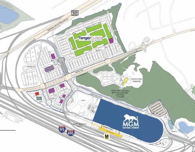
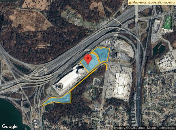
Property Record
201 Mgm National Ave, Oxon Hill, MD 20745

NEARBY LISTINGS FOR SALE OR LEASE
Property Detail
201 Mgm National Ave
12-3878220
PT PARCEL 94
Commercialnec
Prince George's
X
Maryland
5155190045F
21.63 AC
2024
NatHbr/OxnHill/FtWash
2025
Washington, DC
801707
Washington-Arlington-Alexandria, DC-VA-MD-WV
DEMOGRAPHICS near 201 Mgm National Ave
1 Mile
3 Mile
5 Mile
2024 Total Population
8,313
114,727
326,904
2029 Population
8,161
110,358
315,035
Pop Growth 2024-2029
(1.83%)
(3.81%)
(3.63%)
Average Age
41
40
39
2024 Total Households
3,013
49,403
137,737
HH Growth 2024-2029
(1.89%)
(3.85%)
(3.68%)
Median Household Inc
$86,296
$83,160
$88,961
Avg Household Size
2.70
2.30
2.30
2024 Avg HH Vehicles
2.00
1.00
1.00
Median Home Value
$319,054
$404,618
$460,985
Median Year Built
1959
1973
1970
Nearby Places
Map Layers
Map Styles
 Street
 Aerial
- Restaurants
- Banks
- Shops
- Fitness
- Groceries
PUBLIC TRANSPORTATION
COMMUTER RAIL
1 (Fredericksburg Line - Virginia Railway Express, Manassas Line - Virginia Railway Express)
DRIVE
WALK
Distance
1 (Fredericksburg Line - Virginia Railway Express, Manassas Line - Virginia Railway Express)
10 min
5.4 mi
Alexandria (Fredericksburg Line - Virginia Railway Express, Manassas Line - Virginia Railway Express)
DRIVE
WALK
Distance
Alexandria (Fredericksburg Line - Virginia Railway Express, Manassas Line - Virginia Railway Express)
10 min
5.4 mi
AIRPORT
Ronald Reagan Washington Ntl
DRIVE
WALK
Distance
Ronald Reagan Washington Ntl
20 min
8.1 mi
Washington Dulles International
DRIVE
WALK
Distance
Washington Dulles International
55 min
36.1 mi
Freight Ports
Port of Baltimore
DRIVE
WALK
Distance
Port of Baltimore
67 min
44.1 mi
SALE & LEASE HISTORY
LISTING DATE
SALE/LEASE

Jun 22, 2020
For Lease
Aug 07, 2025
For Lease
Nearby Properties
Address
Land Use
TOTAL SIZE
Lot Size
Zoning
Address
Land Use
TOTAL SIZE
Lot Size
Zoning
1,241,298 SF
11.53 AC
RTOLE
Address
Land Use
TOTAL SIZE
Lot Size
Zoning
2,308,874 SF
22.78 AC
RR
Address
Land Use
TOTAL SIZE
Lot Size
Zoning
1,719,751 SF
39.48 AC
PDR-3;UNZO
Address
Land Use
TOTAL SIZE
Lot Size
Zoning
1,931,127 SF
11.53 AC
RTOLE
Address
Land Use
TOTAL SIZE
Lot Size
Zoning
1,278,930 SF
28.17 AC
350
Address
Land Use
TOTAL SIZE
Lot Size
Zoning
360,007 SF
35.80 AC
UT
Address
Land Use
TOTAL SIZE
Lot Size
Zoning
336,904 SF
2.12 AC
CDD#15
Address
Land Use
TOTAL SIZE
Lot Size
Zoning
445,727 SF
12.82 AC
RC
Address
Land Use
TOTAL SIZE
Lot Size
Zoning
315,876 SF
1.55 AC
OCH
Address
Land Use
TOTAL SIZE
Lot Size
Zoning
288,675 SF
2 AC
RM
Address
Land Use
TOTAL SIZE
Lot Size
Zoning
556,384 SF
2.59 AC
CRMU/H
Address
Land Use
TOTAL SIZE
Lot Size
Zoning
1,000,000 SF
84 AC
UNZONED
Address
Land Use
TOTAL SIZE
Lot Size
Zoning
373,996 SF
37.74 AC
IE
Address
Land Use
TOTAL SIZE
Lot Size
Zoning
358,188 SF
2.44 AC
CDD#1
Address
Land Use
TOTAL SIZE
Lot Size
Zoning
1.43 AC
CDD#1
Address
Land Use
TOTAL SIZE
Lot Size
Zoning
1,200,000 SF
28.25 AC
UNZONED
Address
Land Use
TOTAL SIZE
Lot Size
Zoning
303,569 SF
2.52 AC
CDD#10
Address
Land Use
TOTAL SIZE
Lot Size
Zoning
900,000 SF
21.18 AC
UNZONED
Address
Land Use
TOTAL SIZE
Lot Size
Zoning
454,720 SF
11.52 AC
RC
Address
Land Use
TOTAL SIZE
Lot Size
Zoning
258,963 SF
1 AC
CRMU/H
Address
Land Use
TOTAL SIZE
Lot Size
Zoning
274,244 SF
6.24 AC
RA-1
Address
Land Use
TOTAL SIZE
Lot Size
Zoning
1.14 AC
CDD#1
Address
Land Use
TOTAL SIZE
Lot Size
Zoning
263,018 SF
0.66 AC
CDD#15
Address
Land Use
TOTAL SIZE
Lot Size
Zoning
54.40 AC
WPR
Address
Land Use
TOTAL SIZE
Lot Size
Zoning
374,097 SF
36.22 AC
NAC
Address
Land Use
TOTAL SIZE
Lot Size
Zoning
587,628 SF
3.18 AC
RTOLC
Address
Land Use
TOTAL SIZE
Lot Size
Zoning
171,939 SF
10.28 AC
RB
Address
Land Use
TOTAL SIZE
Lot Size
Zoning
473,030 SF
3.08 AC
RA-1
Address
Land Use
TOTAL SIZE
Lot Size
Zoning
329,841 SF
2 AC
CRMU/H
Address
Land Use
TOTAL SIZE
Lot Size
Zoning
286,000 SF
23.88 AC
RB
The World's #1 Commercial Real Estate Marketplace
Connect with us
© 2026 CoStar Group
The information above has been obtained from sources believed reliable. While we do not doubt its accuracy we have not verified it and make no guarantee, warranty or representation about it. It is your responsibility to independently confirm its accuracy and completeness. Any projections, opinions, assumptions, or estimates used are for example only and do not represent the current or future performance of the property. The value of this transaction to you depends on tax and other factors which should be evaluated by your tax, financial, and legal advisors. You and your advisors should conduct a careful, independent investigation of the property to determine to your satisfaction the suitability of the property for your needs.