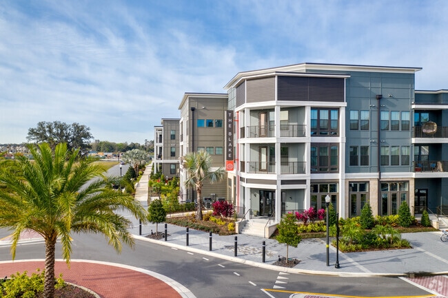
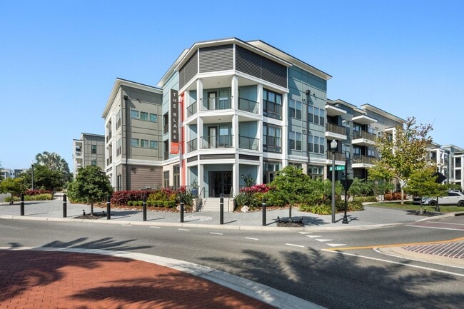
Property Record
201 Michael Blake Blvd, Winter Springs, FL 32708

NEARBY LISTINGS FOR SALE OR LEASE
-
-
View all Winter Springs listings for sale on LoopNet.com
Property Detail
201 Michael Blake Blvd
Orlando-Kissimmee-Sanford, FL
Winter Springs Apartments - A Replat
06-21-31-506-0000-0010
LOT 2 WINTER SPRINGS APARTMENTS - A REPLAT PLAT BOOK 82 PAGES 63-66
Multifamilydwelling
Seminole
X
Florida
12117C0160F
2
2025
1.89 AC
2025
Town Center
021306
Orlando
30,627 SF
DEMOGRAPHICS near 201 Michael Blake Blvd
1 Mile
3 Mile
5 Mile
2024 Total Population
7,079
43,360
139,096
2029 Population
7,510
44,994
144,325
Pop Growth 2024-2029
+ 6.09%
+ 3.77%
+ 3.76%
Average Age
40
42
41
2024 Total Households
2,826
16,557
52,314
HH Growth 2024-2029
+ 6.23%
+ 3.90%
+ 3.85%
Median Household Inc
$95,692
$87,011
$71,908
Avg Household Size
2.50
2.60
2.60
2024 Avg HH Vehicles
2.00
2.00
2.00
Median Home Value
$353,533
$351,943
$317,552
Median Year Built
2001
1989
1987
Nearby Places
Map Layers
Map Styles
 Street
 Aerial
- Restaurants
- Banks
- Shops
- Fitness
- Groceries
PUBLIC TRANSPORTATION
COMMUTER RAIL
Longwood (SunRail - Florida Department of Transportation)
DRIVE
WALK
Distance
Longwood (SunRail - Florida Department of Transportation)
12 min
6.0 mi
Lake Mary (SunRail - Florida Department of Transportation)
DRIVE
WALK
Distance
Lake Mary (SunRail - Florida Department of Transportation)
14 min
8.1 mi
AIRPORT
Orlando Sanford International
DRIVE
WALK
Distance
Orlando Sanford International
18 min
10.9 mi
Orlando International
DRIVE
WALK
Distance
Orlando International
35 min
26.9 mi
Freight Ports
Port Canaveral
DRIVE
WALK
Distance
Port Canaveral
72 min
59.9 mi
Nearby Properties
Address
Land Use
TOTAL SIZE
Lot Size
Zoning
Address
Land Use
TOTAL SIZE
Lot Size
Zoning
581 SF
29.77 AC
Address
Land Use
TOTAL SIZE
Lot Size
Zoning
351,501 SF
4.45 AC
TC
Address
Land Use
TOTAL SIZE
Lot Size
Zoning
25,480 SF
23.86 AC
PUD
Address
Land Use
TOTAL SIZE
Lot Size
Zoning
387,705 SF
61.24 AC
TC
Address
Land Use
TOTAL SIZE
Lot Size
Zoning
141,356 SF
5.07 AC
Address
Land Use
TOTAL SIZE
Lot Size
Zoning
25,488 SF
2.54 AC
Address
Land Use
TOTAL SIZE
Lot Size
Zoning
55,542 SF
9.72 AC
TC
Address
Land Use
TOTAL SIZE
Lot Size
Zoning
25,488 SF
2.19 AC
Address
Land Use
TOTAL SIZE
Lot Size
Zoning
77,228 SF
3.52 AC
PUD
Address
Land Use
TOTAL SIZE
Lot Size
Zoning
91,847 SF
12.03 AC
C2
Address
Land Use
TOTAL SIZE
Lot Size
Zoning
72,120 SF
7.67 AC
C2
Address
Land Use
TOTAL SIZE
Lot Size
Zoning
586,237 SF
43.13 AC
Address
Land Use
TOTAL SIZE
Lot Size
Zoning
35.82 AC
Address
Land Use
TOTAL SIZE
Lot Size
Zoning
24,100 SF
14.32 AC
PUD
Address
Land Use
TOTAL SIZE
Lot Size
Zoning
90,840 SF
2.54 AC
Address
Land Use
TOTAL SIZE
Lot Size
Zoning
69,303 SF
1.54 AC
TC
Address
Land Use
TOTAL SIZE
Lot Size
Zoning
178,855 SF
34.08 AC
PUD
Address
Land Use
TOTAL SIZE
Lot Size
Zoning
Address
Land Use
TOTAL SIZE
Lot Size
Zoning
58,302 SF
8.97 AC
A1
Address
Land Use
TOTAL SIZE
Lot Size
Zoning
63,072 SF
8.76 AC
PUD
Address
Land Use
TOTAL SIZE
Lot Size
Zoning
43,216 SF
5.51 AC
PUD
Address
Land Use
TOTAL SIZE
Lot Size
Zoning
212,104 SF
14.17 AC
PUD
Address
Land Use
TOTAL SIZE
Lot Size
Zoning
61,491 SF
3.86 AC
C1
Address
Land Use
TOTAL SIZE
Lot Size
Zoning
40,332 SF
2.40 AC
PUD
Address
Land Use
TOTAL SIZE
Lot Size
Zoning
29,498 SF
3.86 AC
PUD
Address
Land Use
TOTAL SIZE
Lot Size
Zoning
13.63 AC
OC
Address
Land Use
TOTAL SIZE
Lot Size
Zoning
1,861 SF
7.99 AC
C1
Address
Land Use
TOTAL SIZE
Lot Size
Zoning
57,024 SF
5.18 AC
R3
Address
Land Use
TOTAL SIZE
Lot Size
Zoning
18,424 SF
3.28 AC
A1
The World's #1 Commercial Real Estate Marketplace
Connect with us
© 2025 CoStar Group
The information above has been obtained from sources believed reliable. While we do not doubt its accuracy we have not verified it and make no guarantee, warranty or representation about it. It is your responsibility to independently confirm its accuracy and completeness. Any projections, opinions, assumptions, or estimates used are for example only and do not represent the current or future performance of the property. The value of this transaction to you depends on tax and other factors which should be evaluated by your tax, financial, and legal advisors. You and your advisors should conduct a careful, independent investigation of the property to determine to your satisfaction the suitability of the property for your needs.