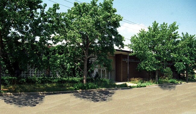
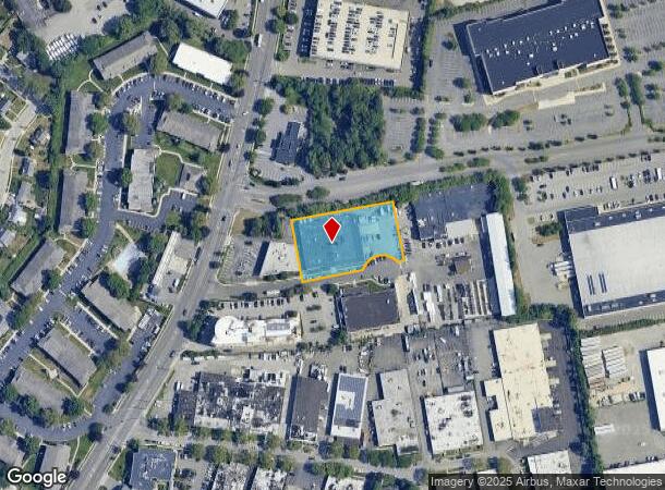
Property Record
201 Montrose Rd, Westbury, NY 11590
NEARBY LISTINGS FOR SALE OR LEASE
Property Detail
201 Montrose Rd
2489-11-B-00-1008-0
TOWN #3 SCH DIST 015
Warehouse
Nassau
X
New York
36059C0145G
1008
2025
1.01 AC
2025
Eastern Nassau
518501
Long Island (New York)
19,955 SF
Nassau County-Suffolk County, NY
DEMOGRAPHICS near 201 Montrose Rd
1 Mile
3 Mile
5 Mile
2024 Total Population
12,839
108,217
315,216
2029 Population
12,689
106,279
310,141
Pop Growth 2024-2029
(1.17%)
(1.79%)
(1.61%)
Average Age
40
41
42
2024 Total Households
3,343
32,223
99,915
HH Growth 2024-2029
(1.14%)
(1.88%)
(1.67%)
Median Household Inc
$142,357
$129,124
$134,170
Avg Household Size
3.30
3.10
3.00
2024 Avg HH Vehicles
2.00
2.00
2.00
Median Home Value
$722,272
$673,500
$689,851
Median Year Built
1959
1955
1955
Nearby Places
- Restaurants
- Banks
- Shops
- Fitness
- Groceries
PUBLIC TRANSPORTATION
COMMUTER RAIL
Westbury Station (Port Jefferson Branch - Long Island Rail Road)
DRIVE
WALK
Distance
Westbury Station (Port Jefferson Branch - Long Island Rail Road)
4 min
2.2 mi
Hicksville Station (Montauk Branch - Long Island Rail Road, Port Jefferson Branch - Long Island Rail Road, Ronkonkoma Branch - Long Island Rail Road)
DRIVE
WALK
Distance
Hicksville Station (Montauk Branch - Long Island Rail Road, Port Jefferson Branch - Long Island Rail Road, Ronkonkoma Branch - Long Island Rail Road)
4 min
2.9 mi
AIRPORT
John F Kennedy International
DRIVE
WALK
Distance
John F Kennedy International
31 min
19.0 mi
LaGuardia
DRIVE
WALK
Distance
LaGuardia
31 min
20.5 mi
Westchester County
DRIVE
WALK
Distance
Westchester County
61 min
40.9 mi
Freight Ports
NY - Red Hook Container Terminal
DRIVE
WALK
Distance
NY - Red Hook Container Terminal
42 min
28.6 mi
Nearby Properties
Address
Land Use
TOTAL SIZE
Lot Size
Zoning
Address
Land Use
TOTAL SIZE
Lot Size
Zoning
114,205 SF
14.06 AC
497
Address
Land Use
TOTAL SIZE
Lot Size
Zoning
729,696 SF
579.18 AC
Address
Land Use
TOTAL SIZE
Lot Size
Zoning
170,920 SF
27.82 AC
Address
Land Use
TOTAL SIZE
Lot Size
Zoning
Address
Land Use
TOTAL SIZE
Lot Size
Zoning
568,086 SF
21.99 AC
Address
Land Use
TOTAL SIZE
Lot Size
Zoning
493,535 SF
5.88 AC
Address
Land Use
TOTAL SIZE
Lot Size
Zoning
469,586 SF
53.14 AC
Address
Land Use
TOTAL SIZE
Lot Size
Zoning
352,730 SF
41.04 AC
Address
Land Use
TOTAL SIZE
Lot Size
Zoning
1,068,978 SF
56.12 AC
Address
Land Use
TOTAL SIZE
Lot Size
Zoning
143,519 SF
20.67 AC
Address
Land Use
TOTAL SIZE
Lot Size
Zoning
35,718 SF
22.15 AC
Address
Land Use
TOTAL SIZE
Lot Size
Zoning
505,020 SF
58.54 AC
Address
Land Use
TOTAL SIZE
Lot Size
Zoning
432,954 SF
26.25 AC
Address
Land Use
TOTAL SIZE
Lot Size
Zoning
331,084 SF
26.95 AC
Address
Land Use
TOTAL SIZE
Lot Size
Zoning
197,357 SF
32.05 AC
Address
Land Use
TOTAL SIZE
Lot Size
Zoning
2,520,272 SF
36.98 AC
Address
Land Use
TOTAL SIZE
Lot Size
Zoning
66,602 SF
19.93 AC
Address
Land Use
TOTAL SIZE
Lot Size
Zoning
12,261 SF
12.83 AC
Address
Land Use
TOTAL SIZE
Lot Size
Zoning
60,571 SF
127.50 AC
Address
Land Use
TOTAL SIZE
Lot Size
Zoning
130,994 SF
27.94 AC
Address
Land Use
TOTAL SIZE
Lot Size
Zoning
98,802 SF
9.70 AC
Address
Land Use
TOTAL SIZE
Lot Size
Zoning
393,511 SF
13.07 AC
Address
Land Use
TOTAL SIZE
Lot Size
Zoning
219,370 SF
15.31 AC
Address
Land Use
TOTAL SIZE
Lot Size
Zoning
178,455 SF
14.91 AC
Address
Land Use
TOTAL SIZE
Lot Size
Zoning
198,959 SF
7.79 AC
Address
Land Use
TOTAL SIZE
Lot Size
Zoning
147,175 SF
10.28 AC
Address
Land Use
TOTAL SIZE
Lot Size
Zoning
204,726 SF
28.34 AC
Address
Land Use
TOTAL SIZE
Lot Size
Zoning
105,618 SF
23.48 AC
Address
Land Use
TOTAL SIZE
Lot Size
Zoning
487,977 SF
26.39 AC
Address
Land Use
TOTAL SIZE
Lot Size
Zoning
69,168 SF
15.12 AC
The World's #1 Commercial Real Estate Marketplace
Connect with us
© 2025 CoStar Group
The information above has been obtained from sources believed reliable. While we do not doubt its accuracy we have not verified it and make no guarantee, warranty or representation about it. It is your responsibility to independently confirm its accuracy and completeness. Any projections, opinions, assumptions, or estimates used are for example only and do not represent the current or future performance of the property. The value of this transaction to you depends on tax and other factors which should be evaluated by your tax, financial, and legal advisors. You and your advisors should conduct a careful, independent investigation of the property to determine to your satisfaction the suitability of the property for your needs.