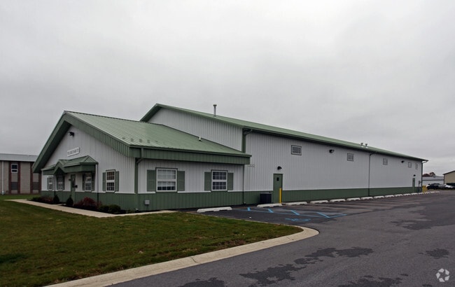
Property Record
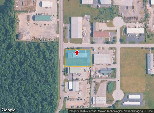
201 N Colfax St, Griffith, IN 46319
Current Lease Availabilities
NEARBY LISTINGS FOR SALE OR LEASE
Property Detail
201 N Colfax St
Chicago-Naperville-Elgin, IL-IN-WI
Gatlins Addition Phase 1
45-11-01-102-001.000-033
GATLINS ADDITION PHASE 1 LOT 12
Lightindustrial
Lake
X
Indiana
18089C0143E
12
2023
1.37 AC
2024
Indiana
041400
Chicago
14,000 SF
DEMOGRAPHICS near 201 N Colfax St
1 Mile
3 Mile
5 Mile
2024 Total Population
3,117
46,778
166,073
2029 Population
3,127
46,587
166,831
Pop Growth 2024-2029
+ 0.32%
(0.41%)
+ 0.46%
Average Age
41
41
41
2024 Total Households
1,246
18,897
66,606
HH Growth 2024-2029
+ 0.40%
(0.44%)
+ 0.37%
Median Household Inc
$73,079
$70,596
$63,933
Avg Household Size
2.40
2.40
2.40
2024 Avg HH Vehicles
2.00
2.00
2.00
Median Home Value
$174,840
$197,839
$200,175
Median Year Built
1957
1968
1970
Nearby Places
Map Layers
Map Styles
 Street
 Aerial
- Restaurants
- Banks
- Shops
- Fitness
- Groceries
PUBLIC TRANSPORTATION
COMMUTER RAIL
DRIVE
WALK
Distance
16 min
6.1 mi
Clark Road (Gary) Station (South Shore Line - Northern Indiana Commuter Transportation District (South Shore Line))
DRIVE
WALK
Distance
Clark Road (Gary) Station (South Shore Line - Northern Indiana Commuter Transportation District (South Shore Line))
15 min
7.0 mi
AIRPORT
Chicago Midway International
DRIVE
WALK
Distance
Chicago Midway International
53 min
33.0 mi
Nearby Properties
Address
Land Use
TOTAL SIZE
Lot Size
Zoning
Address
Land Use
TOTAL SIZE
Lot Size
Zoning
206,854 SF
8.38 AC
Address
Land Use
TOTAL SIZE
Lot Size
Zoning
168,766 SF
19.16 AC
Address
Land Use
TOTAL SIZE
Lot Size
Zoning
190,457 SF
10.63 AC
Address
Land Use
TOTAL SIZE
Lot Size
Zoning
80,444 SF
13.41 AC
R3
Address
Land Use
TOTAL SIZE
Lot Size
Zoning
132,147 SF
44.38 AC
R33
Address
Land Use
TOTAL SIZE
Lot Size
Zoning
64,971 SF
6.98 AC
Address
Land Use
TOTAL SIZE
Lot Size
Zoning
119,059 SF
10.12 AC
R33
Address
Land Use
TOTAL SIZE
Lot Size
Zoning
45,397 SF
14.48 AC
Address
Land Use
TOTAL SIZE
Lot Size
Zoning
34,116 SF
73.40 AC
Address
Land Use
TOTAL SIZE
Lot Size
Zoning
47,881 SF
23.63 AC
R33
Address
Land Use
TOTAL SIZE
Lot Size
Zoning
105,600 SF
2.90 AC
Address
Land Use
TOTAL SIZE
Lot Size
Zoning
12,087 SF
22 AC
Address
Land Use
TOTAL SIZE
Lot Size
Zoning
68.50 AC
Address
Land Use
TOTAL SIZE
Lot Size
Zoning
66,464 SF
43.30 AC
Address
Land Use
TOTAL SIZE
Lot Size
Zoning
33,920 SF
83.34 AC
Address
Land Use
TOTAL SIZE
Lot Size
Zoning
148,851 SF
20.81 AC
Address
Land Use
TOTAL SIZE
Lot Size
Zoning
121,900 SF
8.79 AC
R3
Address
Land Use
TOTAL SIZE
Lot Size
Zoning
79,059 SF
7.07 AC
R3
Address
Land Use
TOTAL SIZE
Lot Size
Zoning
111,363 SF
9.60 AC
Address
Land Use
TOTAL SIZE
Lot Size
Zoning
98,658 SF
7.26 AC
R33
Address
Land Use
TOTAL SIZE
Lot Size
Zoning
6,760 SF
77.37 AC
Address
Land Use
TOTAL SIZE
Lot Size
Zoning
14,501 SF
70.85 AC
Address
Land Use
TOTAL SIZE
Lot Size
Zoning
44,960 SF
4.80 AC
Address
Land Use
TOTAL SIZE
Lot Size
Zoning
38,988 SF
7.27 AC
R33
Address
Land Use
TOTAL SIZE
Lot Size
Zoning
41,406 SF
2.80 AC
R33
Address
Land Use
TOTAL SIZE
Lot Size
Zoning
24,964 SF
3.72 AC
Address
Land Use
TOTAL SIZE
Lot Size
Zoning
105,520 SF
17.52 AC
Address
Land Use
TOTAL SIZE
Lot Size
Zoning
11,373 SF
6.41 AC
Address
Land Use
TOTAL SIZE
Lot Size
Zoning
163,852 SF
32 AC
Address
Land Use
TOTAL SIZE
Lot Size
Zoning
28,674 SF
6.87 AC
The World's #1 Commercial Real Estate Marketplace
Connect with us
© 2025 CoStar Group
The information above has been obtained from sources believed reliable. While we do not doubt its accuracy we have not verified it and make no guarantee, warranty or representation about it. It is your responsibility to independently confirm its accuracy and completeness. Any projections, opinions, assumptions, or estimates used are for example only and do not represent the current or future performance of the property. The value of this transaction to you depends on tax and other factors which should be evaluated by your tax, financial, and legal advisors. You and your advisors should conduct a careful, independent investigation of the property to determine to your satisfaction the suitability of the property for your needs.