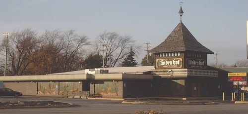
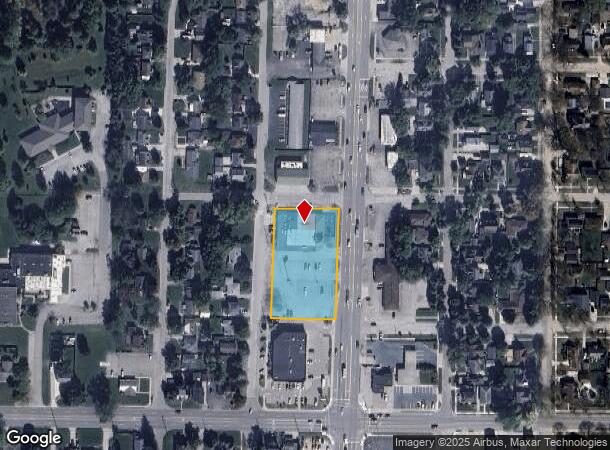
Property Record
201 N Euclid Ave, Bay City, MI 48706
NEARBY LISTINGS FOR SALE OR LEASE
Property Detail
201 N Euclid Ave
Bay City, MI
Lenox Park
09-010-L20-006-001-00
LOTS 1 THRU 6 & 17 THUR 22 BLK 6 LENOX PARK PLAT AS RECORDED IN LIBER 4 OF PLATS PAGE 6 OF BAY COUNTY RECORDS
Restaurantbuilding
Bay
X
Michigan
26145C0075E
1-6
2024
1.31 AC
2025
Midland/Flint
285800
Other Market Areas
10,982 SF
DEMOGRAPHICS near 201 N Euclid Ave
1 Mile
3 Mile
5 Mile
2024 Total Population
9,550
48,990
69,901
2029 Population
9,417
48,526
69,257
Pop Growth 2024-2029
(1.39%)
(0.95%)
(0.92%)
Average Age
42
42
43
2024 Total Households
4,295
21,444
30,849
HH Growth 2024-2029
(1.51%)
(1.03%)
(0.94%)
Median Household Inc
$50,831
$49,872
$51,862
Avg Household Size
2.20
2.20
2.20
2024 Avg HH Vehicles
2.00
2.00
2.00
Median Home Value
$86,459
$83,953
$97,980
Median Year Built
1951
1952
1956
Nearby Places
Map Layers
Map Styles
 Street
 Aerial
- Restaurants
- Banks
- Shops
- Fitness
- Groceries
PUBLIC TRANSPORTATION
AIRPORT
MBS International
DRIVE
WALK
Distance
MBS International
20 min
13.7 mi
Freight Ports
Port of Toledo
DRIVE
WALK
Distance
Port of Toledo
181 min
158.4 mi
Nearby Properties
Address
Land Use
TOTAL SIZE
Lot Size
Zoning
Address
Land Use
TOTAL SIZE
Lot Size
Zoning
97,304 SF
3.61 AC
C-3 CTRL B
Address
Land Use
TOTAL SIZE
Lot Size
Zoning
164,241 SF
10.08 AC
RM-1
Address
Land Use
TOTAL SIZE
Lot Size
Zoning
16.52 AC
R-3
Address
Land Use
TOTAL SIZE
Lot Size
Zoning
279,395 SF
192 AC
I-2
Address
Land Use
TOTAL SIZE
Lot Size
Zoning
167,100 SF
35.59 AC
M-2 GEN IN
Address
Land Use
TOTAL SIZE
Lot Size
Zoning
60,200 SF
9.50 AC
C-3 CTRL B
Address
Land Use
TOTAL SIZE
Lot Size
Zoning
169,440 SF
16.54 AC
RM-1
Address
Land Use
TOTAL SIZE
Lot Size
Zoning
1.87 AC
C-3 CTRL B
Address
Land Use
TOTAL SIZE
Lot Size
Zoning
57,000 SF
1.09 AC
C-3 CTRL B
Address
Land Use
TOTAL SIZE
Lot Size
Zoning
41,011 SF
8.28 AC
C-2
Address
Land Use
TOTAL SIZE
Lot Size
Zoning
15.15 AC
M-1 LT IND
Address
Land Use
TOTAL SIZE
Lot Size
Zoning
50,965 SF
0.83 AC
C-3 CTRL B
Address
Land Use
TOTAL SIZE
Lot Size
Zoning
22,356 SF
I-2
Address
Land Use
TOTAL SIZE
Lot Size
Zoning
39,417 SF
0.23 AC
C-3 CTRL B
Address
Land Use
TOTAL SIZE
Lot Size
Zoning
63,200 SF
1.97 AC
C-3 CTRL B
Address
Land Use
TOTAL SIZE
Lot Size
Zoning
C-3 CTRL B
Address
Land Use
TOTAL SIZE
Lot Size
Zoning
45,072 SF
4.81 AC
C-2B HWY B
Address
Land Use
TOTAL SIZE
Lot Size
Zoning
156,600 SF
9.11 AC
M-1 LT IND
Address
Land Use
TOTAL SIZE
Lot Size
Zoning
7,200 SF
0.69 AC
C-3 CTRL B
Address
Land Use
TOTAL SIZE
Lot Size
Zoning
139,237 SF
5.47 AC
C-3 CTRL B
Address
Land Use
TOTAL SIZE
Lot Size
Zoning
163,673 SF
17.85 AC
RM-1
Address
Land Use
TOTAL SIZE
Lot Size
Zoning
M-1 LT IND
Address
Land Use
TOTAL SIZE
Lot Size
Zoning
Address
Land Use
TOTAL SIZE
Lot Size
Zoning
107,921 SF
10.91 AC
C-2
Address
Land Use
TOTAL SIZE
Lot Size
Zoning
1.91 AC
Address
Land Use
TOTAL SIZE
Lot Size
Zoning
85,264 SF
5 AC
RM-1
Address
Land Use
TOTAL SIZE
Lot Size
Zoning
32.23 AC
C
Address
Land Use
TOTAL SIZE
Lot Size
Zoning
36,243 SF
3.41 AC
C-2
Address
Land Use
TOTAL SIZE
Lot Size
Zoning
109,649 SF
11.29 AC
C-2
Address
Land Use
TOTAL SIZE
Lot Size
Zoning
60,889 SF
The World's #1 Commercial Real Estate Marketplace
Connect with us
© 2025 CoStar Group
The information above has been obtained from sources believed reliable. While we do not doubt its accuracy we have not verified it and make no guarantee, warranty or representation about it. It is your responsibility to independently confirm its accuracy and completeness. Any projections, opinions, assumptions, or estimates used are for example only and do not represent the current or future performance of the property. The value of this transaction to you depends on tax and other factors which should be evaluated by your tax, financial, and legal advisors. You and your advisors should conduct a careful, independent investigation of the property to determine to your satisfaction the suitability of the property for your needs.