Property Record
201 N Forest Ave, Independence, MO 64050
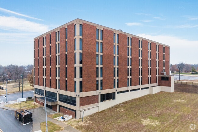
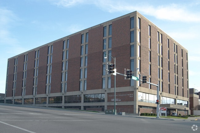
Property Detail
201 N Forest Ave
Kansas City, MO-KS
KENSINGTON ADD N 124 OF W 280 OF LOT 1
26-330-03-02-00-0-00-000
Jackson
Officebuilding
Missouri
B and X Area of moderate flood hazard, usually the area between the limits of the 100-year and 500-year floods.
1
2024
5.47 AC
2025
East Jackson County
011502
Kansas City
224,427 SF
NEARBY LISTINGS FOR SALE OR LEASE
DEMOGRAPHICS near 201 N Forest Ave
1 mile
3 mile
5 mile
2025 Total Population
11,578
64,319
149,399
2030 Population
11,801
65,146
150,941
Pop Growth 2025-2030
+ 1.93%
+ 1.29%
+ 1.03%
Average Age
41
40
40
2025 Total Households
5,101
26,554
59,748
HH Growth 2025-2030
+ 1.90%
+ 1.28%
+ 0.93%
Median Household Inc
$42,510
$55,180
$55,745
Avg Household Size
2.10
2.30
2.40
2025 Avg HH Vehicles
1.00
2.00
2.00
Median Home Value
$136,502
$146,091
$157,851
Median Year Built
1949
1955
1963
Nearby Places
Map Layers
Map Styles
 Street
 Aerial
Transit
 Traffic
 Biking
Places
Listings with unknown addresses are not visible on the map
- Restaurants
- Banks
- Shops
- Fitness
- Groceries
PUBLIC TRANSPORTATION
COMMUTER RAIL
Drive
Walk
Distance
3 min
15 min
0.8 mi
Drive
Walk
Distance
20 min
9.3 mi
AIRPORT
Kansas City International
Drive
Walk
Distance
Kansas City International
40 min
29.4 mi
SALE & LEASE HISTORY
LISTING DATE
SALE/LEASE

Jan 19, 2017
For Lease
Jan 06, 2017
For Lease
Aug 25, 2021
For Lease
Nearby Properties
Address
Land Use
TOTAL SIZE
Lot Size
Zoning
Address
Land Use
TOTAL SIZE
Lot Size
Zoning
519,315 SF
28.47 AC
Address
Land Use
TOTAL SIZE
Lot Size
Zoning
7,962 SF
7.80 AC
Address
Land Use
TOTAL SIZE
Lot Size
Zoning
455,100 SF
42.02 AC
Address
Land Use
TOTAL SIZE
Lot Size
Zoning
123,305 SF
15.51 AC
Address
Land Use
TOTAL SIZE
Lot Size
Zoning
64,318 SF
32.40 AC
Address
Land Use
TOTAL SIZE
Lot Size
Zoning
213,615 SF
15.50 AC
Address
Land Use
TOTAL SIZE
Lot Size
Zoning
74,801 SF
8.93 AC
Address
Land Use
TOTAL SIZE
Lot Size
Zoning
157,666 SF
18.54 AC
Address
Land Use
TOTAL SIZE
Lot Size
Zoning
139,713 SF
15.70 AC
Address
Land Use
TOTAL SIZE
Lot Size
Zoning
13,227 SF
287 AC
Address
Land Use
TOTAL SIZE
Lot Size
Zoning
71,339 SF
0.68 AC
Address
Land Use
TOTAL SIZE
Lot Size
Zoning
113,667 SF
6.31 AC
Address
Land Use
TOTAL SIZE
Lot Size
Zoning
190,810 SF
26.90 AC
Address
Land Use
TOTAL SIZE
Lot Size
Zoning
55,985 SF
20.93 AC
Address
Land Use
TOTAL SIZE
Lot Size
Zoning
36,883 SF
14.60 AC
Address
Land Use
TOTAL SIZE
Lot Size
Zoning
286,490 SF
37.30 AC
Address
Land Use
TOTAL SIZE
Lot Size
Zoning
66,168 SF
44.98 AC
Address
Land Use
TOTAL SIZE
Lot Size
Zoning
79,609 SF
2.91 AC
Address
Land Use
TOTAL SIZE
Lot Size
Zoning
39,120 SF
1.87 AC
Address
Land Use
TOTAL SIZE
Lot Size
Zoning
50,900 SF
13.80 AC
Address
Land Use
TOTAL SIZE
Lot Size
Zoning
58,946 SF
0.98 AC
Address
Land Use
TOTAL SIZE
Lot Size
Zoning
67,282 SF
4 AC
Address
Land Use
TOTAL SIZE
Lot Size
Zoning
62,230 SF
11.80 AC
Address
Land Use
TOTAL SIZE
Lot Size
Zoning
69,203 SF
11.35 AC
Address
Land Use
TOTAL SIZE
Lot Size
Zoning
62,686 SF
1.98 AC
Address
Land Use
TOTAL SIZE
Lot Size
Zoning
70,772 SF
25.59 AC
Address
Land Use
TOTAL SIZE
Lot Size
Zoning
41,101 SF
4.46 AC
Address
Land Use
TOTAL SIZE
Lot Size
Zoning
154,844 SF
11.66 AC
Address
Land Use
TOTAL SIZE
Lot Size
Zoning
41,030 SF
5.88 AC
Address
Land Use
TOTAL SIZE
Lot Size
Zoning
31,448 SF
8.50 AC
The World's #1 Commercial Real Estate Marketplace
Connect with us
© 2026 CoStar Group
The information above has been obtained from sources believed reliable. While we do not doubt its accuracy we have not verified it and make no guarantee, warranty or representation about it. It is your responsibility to independently confirm its accuracy and completeness. Any projections, opinions, assumptions, or estimates used are for example only and do not represent the current or future performance of the property. The value of this transaction to you depends on tax and other factors which should be evaluated by your tax, financial, and legal advisors. You and your advisors should conduct a careful, independent investigation of the property to determine to your satisfaction the suitability of the property for your needs.