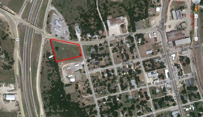
Property Record
201 N School Rd, Rhome, TX 76078

Property Detail
201 N School Rd
Dallas-Fort Worth-Arlington, TX
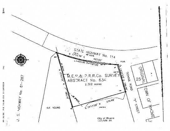
LOT 2 BLK 1 TACO CASA RHOME ADDITION
R2822010200
WISE
Commercialnec
Texas
B and X Area of moderate flood hazard, usually the area between the limits of the 100-year and 500-year floods.
2
2024
1.14 AC
2025
Wise County
150606
Dallas/Ft Worth
3,677 SF
NEARBY LISTINGS FOR SALE OR LEASE
DEMOGRAPHICS near 201 N School Rd
1 mile
3 mile
5 mile
2025 Total Population
1,410
7,048
16,672
2030 Population
1,631
8,221
19,374
Pop Growth 2025-2030
+ 15.67%
+ 16.64%
+ 16.21%
Average Age
37
39
39
2025 Total Households
482
2,380
5,603
HH Growth 2025-2030
+ 15.35%
+ 16.43%
+ 15.94%
Median Household Inc
$92,662
$109,343
$98,023
Avg Household Size
2.90
2.90
2.90
2025 Avg HH Vehicles
2.00
2.00
2.00
Median Home Value
$293,749
$370,547
$338,359
Median Year Built
2002
2003
2003
Nearby Places
Map Layers
Map Styles
 Street
 Aerial
Layers
 Traffic
 Biking
Places
Listings with unknown addresses are not visible on the map
- Restaurants
- Banks
- Shops
- Fitness
- Groceries
PUBLIC TRANSPORTATION
AIRPORT
Dallas-Fort Worth International
Drive
Walk
Distance
Dallas-Fort Worth International
42 min
32.3 mi
SALE & LEASE HISTORY
LISTING DATE
SALE/LEASE

Jun 16, 2020
For Sale
Nearby Properties
Address
Land Use
TOTAL SIZE
Lot Size
Zoning
Address
Land Use
TOTAL SIZE
Lot Size
Zoning
136,400 SF
27.50 AC
Address
Land Use
TOTAL SIZE
Lot Size
Zoning
81,438 SF
6.82 AC
Address
Land Use
TOTAL SIZE
Lot Size
Zoning
64,400 SF
10.08 AC
Address
Land Use
TOTAL SIZE
Lot Size
Zoning
62,600 SF
5.33 AC
Address
Land Use
TOTAL SIZE
Lot Size
Zoning
63,628 SF
8.18 AC
Address
Land Use
TOTAL SIZE
Lot Size
Zoning
68,527 SF
6.91 AC
Address
Land Use
TOTAL SIZE
Lot Size
Zoning
109,740 SF
13.46 AC
Address
Land Use
TOTAL SIZE
Lot Size
Zoning
60,000 SF
5 AC
Address
Land Use
TOTAL SIZE
Lot Size
Zoning
5,000 SF
29.28 AC
Address
Land Use
TOTAL SIZE
Lot Size
Zoning
14,940 SF
10 AC
Address
Land Use
TOTAL SIZE
Lot Size
Zoning
31,752 SF
5.11 AC
Address
Land Use
TOTAL SIZE
Lot Size
Zoning
14,384 SF
28.80 AC
Address
Land Use
TOTAL SIZE
Lot Size
Zoning
49,300 SF
4.16 AC
Address
Land Use
TOTAL SIZE
Lot Size
Zoning
50,600 SF
10.06 AC
Address
Land Use
TOTAL SIZE
Lot Size
Zoning
58,270 SF
6.64 AC
Address
Land Use
TOTAL SIZE
Lot Size
Zoning
25,100 SF
6.93 AC
Address
Land Use
TOTAL SIZE
Lot Size
Zoning
53,200 SF
5 AC
Address
Land Use
TOTAL SIZE
Lot Size
Zoning
24,958 SF
1.78 AC
Address
Land Use
TOTAL SIZE
Lot Size
Zoning
8,850 SF
5.25 AC
Address
Land Use
TOTAL SIZE
Lot Size
Zoning
47,469 SF
4 AC
Address
Land Use
TOTAL SIZE
Lot Size
Zoning
24,762 SF
5 AC
Address
Land Use
TOTAL SIZE
Lot Size
Zoning
20,825 SF
3.24 AC
Address
Land Use
TOTAL SIZE
Lot Size
Zoning
30,300 SF
2.75 AC
Address
Land Use
TOTAL SIZE
Lot Size
Zoning
34.66 AC
Address
Land Use
TOTAL SIZE
Lot Size
Zoning
57,575 SF
3 AC
Address
Land Use
TOTAL SIZE
Lot Size
Zoning
23,740 SF
8.23 AC
Address
Land Use
TOTAL SIZE
Lot Size
Zoning
35,840 SF
4.72 AC
Address
Land Use
TOTAL SIZE
Lot Size
Zoning
19,918 SF
3.80 AC
Address
Land Use
TOTAL SIZE
Lot Size
Zoning
21,750 SF
2.19 AC
The World's #1 Commercial Real Estate Marketplace
Connect with us
© 2026 CoStar Group
The information above has been obtained from sources believed reliable. While we do not doubt its accuracy we have not verified it and make no guarantee, warranty or representation about it. It is your responsibility to independently confirm its accuracy and completeness. Any projections, opinions, assumptions, or estimates used are for example only and do not represent the current or future performance of the property. The value of this transaction to you depends on tax and other factors which should be evaluated by your tax, financial, and legal advisors. You and your advisors should conduct a careful, independent investigation of the property to determine to your satisfaction the suitability of the property for your needs.