Property Record
201 N State Route 7, Pleasant Hill, MO 64080
NEARBY LISTINGS FOR SALE OR LEASE
-
-
View all Pleasant Hill listings for sale on LoopNet.com
Property Detail
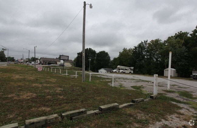
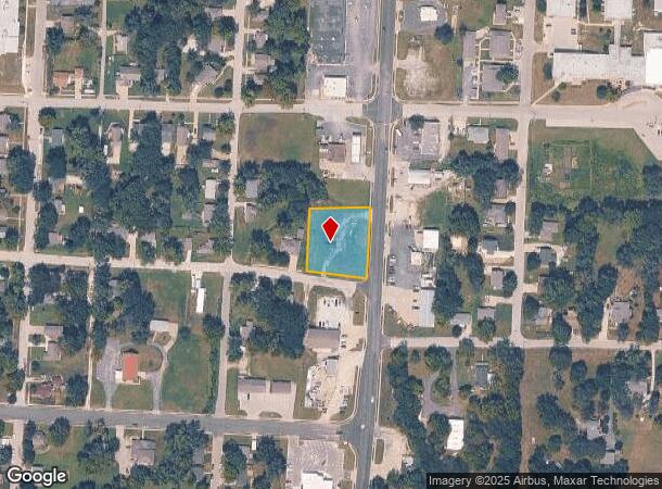
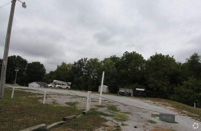
201 N State Route 7
1861000
BG 264S OF CTR MYRTLE & HWY7 W206 S TO OAK EX HWY
Agriculturalland
Cass
X
Missouri
29095C0575G
0.75 AC
2024
Cass County
2025
Kansas City
060602
Kansas City, MO-KS
308 SF
DEMOGRAPHICS near 201 N State Route 7
1 Mile
3 Mile
5 Mile
2024 Total Population
4,829
10,048
12,735
2029 Population
5,137
10,662
13,477
Pop Growth 2024-2029
+ 6.38%
+ 6.11%
+ 5.83%
Average Age
38
39
39
2024 Total Households
1,877
3,726
4,694
HH Growth 2024-2029
+ 6.50%
+ 6.23%
+ 5.94%
Median Household Inc
$69,910
$89,739
$93,545
Avg Household Size
2.50
2.60
2.70
2024 Avg HH Vehicles
2.00
2.00
2.00
Median Home Value
$179,383
$245,011
$269,188
Median Year Built
1974
1993
1992
Nearby Places
Map Layers
Map Styles
 Street
 Aerial
- Restaurants
- Banks
- Shops
- Fitness
- Groceries
Nearby Properties
Address
Land Use
TOTAL SIZE
Lot Size
Zoning
Address
Land Use
TOTAL SIZE
Lot Size
Zoning
42.30 AC
Address
Land Use
TOTAL SIZE
Lot Size
Zoning
Address
Land Use
TOTAL SIZE
Lot Size
Zoning
14,703 SF
10 AC
Address
Land Use
TOTAL SIZE
Lot Size
Zoning
14,703 SF
10 AC
Address
Land Use
TOTAL SIZE
Lot Size
Zoning
24.70 AC
Address
Land Use
TOTAL SIZE
Lot Size
Zoning
18,628 SF
2.07 AC
Address
Land Use
TOTAL SIZE
Lot Size
Zoning
0.78 AC
Address
Land Use
TOTAL SIZE
Lot Size
Zoning
Address
Land Use
TOTAL SIZE
Lot Size
Zoning
84,404 SF
6 AC
Address
Land Use
TOTAL SIZE
Lot Size
Zoning
8,833 SF
1.02 AC
Address
Land Use
TOTAL SIZE
Lot Size
Zoning
13,386 SF
2.60 AC
Address
Land Use
TOTAL SIZE
Lot Size
Zoning
504 SF
2 AC
Address
Land Use
TOTAL SIZE
Lot Size
Zoning
13,608 SF
1.60 AC
Address
Land Use
TOTAL SIZE
Lot Size
Zoning
Address
Land Use
TOTAL SIZE
Lot Size
Zoning
704,326 SF
6.62 AC
Address
Land Use
TOTAL SIZE
Lot Size
Zoning
31,200 SF
4.10 AC
Address
Land Use
TOTAL SIZE
Lot Size
Zoning
452,602 SF
17.50 AC
Address
Land Use
TOTAL SIZE
Lot Size
Zoning
59,336 SF
5 AC
Address
Land Use
TOTAL SIZE
Lot Size
Zoning
6,288 SF
1.39 AC
Address
Land Use
TOTAL SIZE
Lot Size
Zoning
0.92 AC
Address
Land Use
TOTAL SIZE
Lot Size
Zoning
54,310 SF
4.25 AC
Address
Land Use
TOTAL SIZE
Lot Size
Zoning
49,500 SF
8.50 AC
Address
Land Use
TOTAL SIZE
Lot Size
Zoning
13,200 SF
1.53 AC
Address
Land Use
TOTAL SIZE
Lot Size
Zoning
17,280 SF
17.66 AC
Address
Land Use
TOTAL SIZE
Lot Size
Zoning
13,040 SF
2 AC
Address
Land Use
TOTAL SIZE
Lot Size
Zoning
11,200 SF
0.41 AC
Address
Land Use
TOTAL SIZE
Lot Size
Zoning
6,336 SF
0.39 AC
Address
Land Use
TOTAL SIZE
Lot Size
Zoning
6,718 SF
1.50 AC
Address
Land Use
TOTAL SIZE
Lot Size
Zoning
2,477 SF
21 AC
Address
Land Use
TOTAL SIZE
Lot Size
Zoning
4,800 SF
1.86 AC
The World's #1 Commercial Real Estate Marketplace
Connect with us
© 2025 CoStar Group
The information above has been obtained from sources believed reliable. While we do not doubt its accuracy we have not verified it and make no guarantee, warranty or representation about it. It is your responsibility to independently confirm its accuracy and completeness. Any projections, opinions, assumptions, or estimates used are for example only and do not represent the current or future performance of the property. The value of this transaction to you depends on tax and other factors which should be evaluated by your tax, financial, and legal advisors. You and your advisors should conduct a careful, independent investigation of the property to determine to your satisfaction the suitability of the property for your needs.