Property Record
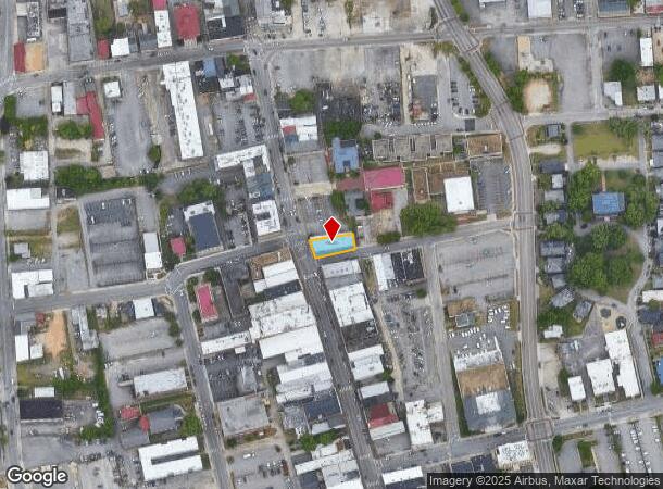
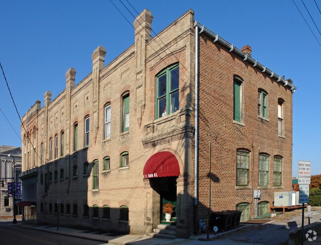
201 N Sycamore St, Petersburg, VA 23803

NEARBY LISTINGS FOR SALE OR LEASE
Property Detail
201 N Sycamore St
011-22-0009
Olde Town (Not Platted)
Storemultistory
46.33-38 X 122-114
X
Petersburg
51041C0435E
Virginia
2023
0.13 AC
2025
Petersburg
811300
Richmond VA
13,527 SF
Richmond, VA
DEMOGRAPHICS near 201 N Sycamore St
1 Mile
3 Mile
5 Mile
2024 Total Population
9,614
51,680
87,212
2029 Population
9,752
52,528
88,913
Pop Growth 2024-2029
+ 1.44%
+ 1.64%
+ 1.95%
Average Age
40
39
38
2024 Total Households
4,856
21,352
32,841
HH Growth 2024-2029
+ 1.44%
+ 1.44%
+ 1.76%
Median Household Inc
$43,521
$48,663
$54,336
Avg Household Size
1.90
2.20
2.30
2024 Avg HH Vehicles
1.00
2.00
2.00
Median Home Value
$146,913
$157,381
$177,059
Median Year Built
1954
1967
1972
Nearby Places
Map Layers
Map Styles
 Street
 Aerial
- Restaurants
- Banks
- Shops
- Fitness
- Groceries
PUBLIC TRANSPORTATION
COMMUTER RAIL
DRIVE
WALK
Distance
4 min
2.0 mi
AIRPORT
Richmond International
DRIVE
WALK
Distance
Richmond International
38 min
28.6 mi
Freight Ports
Virginia Port Authority - Richmond
DRIVE
WALK
Distance
Virginia Port Authority - Richmond
29 min
19.7 mi
Nearby Properties
Address
Land Use
TOTAL SIZE
Lot Size
Zoning
Address
Land Use
TOTAL SIZE
Lot Size
Zoning
500 SF
390.12 AC
R7 - SINGL
Address
Land Use
TOTAL SIZE
Lot Size
Zoning
1,232 SF
571 AC
R1
Address
Land Use
TOTAL SIZE
Lot Size
Zoning
165,942 SF
0.57 AC
R7 - SINGL
Address
Land Use
TOTAL SIZE
Lot Size
Zoning
28.17 AC
PUD
Address
Land Use
TOTAL SIZE
Lot Size
Zoning
51,588 SF
13.86 AC
RMF - RES,
Address
Land Use
TOTAL SIZE
Lot Size
Zoning
359,504 SF
32.59 AC
R-4
Address
Land Use
TOTAL SIZE
Lot Size
Zoning
498.93 AC
Address
Land Use
TOTAL SIZE
Lot Size
Zoning
209,515 SF
21.20 AC
B3
Address
Land Use
TOTAL SIZE
Lot Size
Zoning
95,944 SF
15.75 AC
C2 - NBHD
Address
Land Use
TOTAL SIZE
Lot Size
Zoning
188,368 SF
18.96 AC
B1
Address
Land Use
TOTAL SIZE
Lot Size
Zoning
119,151 SF
3.10 AC
M-1
Address
Land Use
TOTAL SIZE
Lot Size
Zoning
130,698 SF
10.78 AC
PUD
Address
Land Use
TOTAL SIZE
Lot Size
Zoning
223,211 SF
19.99 AC
B3
Address
Land Use
TOTAL SIZE
Lot Size
Zoning
57,011 SF
4.45 AC
BB
Address
Land Use
TOTAL SIZE
Lot Size
Zoning
140,000 SF
1 AC
999
Address
Land Use
TOTAL SIZE
Lot Size
Zoning
14.57 AC
R-4
Address
Land Use
TOTAL SIZE
Lot Size
Zoning
173,829 SF
13.73 AC
B2
Address
Land Use
TOTAL SIZE
Lot Size
Zoning
129,600 SF
12.21 AC
PUD
Address
Land Use
TOTAL SIZE
Lot Size
Zoning
100 SF
12.39 AC
R7 - SINGL
Address
Land Use
TOTAL SIZE
Lot Size
Zoning
128,848 SF
13.24 AC
B3
Address
Land Use
TOTAL SIZE
Lot Size
Zoning
92,701 SF
2.87 AC
B1
Address
Land Use
TOTAL SIZE
Lot Size
Zoning
89,734 SF
2.85 AC
B1
Address
Land Use
TOTAL SIZE
Lot Size
Zoning
86,387 SF
10.91 AC
B3
Address
Land Use
TOTAL SIZE
Lot Size
Zoning
185,483 SF
20.98 AC
R-4
Address
Land Use
TOTAL SIZE
Lot Size
Zoning
65,214 SF
8.46 AC
R-4
Address
Land Use
TOTAL SIZE
Lot Size
Zoning
26.67 AC
R-4
Address
Land Use
TOTAL SIZE
Lot Size
Zoning
6,284 SF
14.29 AC
11
Address
Land Use
TOTAL SIZE
Lot Size
Zoning
3,632 SF
11.30 AC
M-2
Address
Land Use
TOTAL SIZE
Lot Size
Zoning
37,809 SF
150 AC
R7 - SINGL
Address
Land Use
TOTAL SIZE
Lot Size
Zoning
68,438 SF
1.93 AC
The World's #1 Commercial Real Estate Marketplace
Connect with us
© 2025 CoStar Group
The information above has been obtained from sources believed reliable. While we do not doubt its accuracy we have not verified it and make no guarantee, warranty or representation about it. It is your responsibility to independently confirm its accuracy and completeness. Any projections, opinions, assumptions, or estimates used are for example only and do not represent the current or future performance of the property. The value of this transaction to you depends on tax and other factors which should be evaluated by your tax, financial, and legal advisors. You and your advisors should conduct a careful, independent investigation of the property to determine to your satisfaction the suitability of the property for your needs.