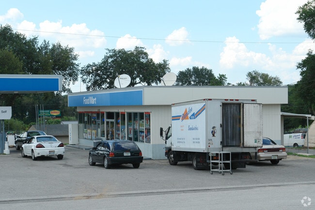
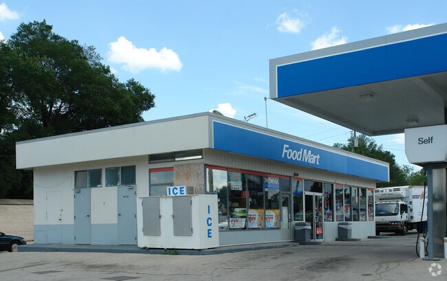
Property Record
201 N Us Highway 27/441, Lady Lake, FL 32159
NEARBY LISTINGS FOR SALE OR LEASE
Property Detail
201 N Us Highway 27/441
Orlando-Kissimmee-Sanford, FL
Lady Lake
20-18-24-0400-000-05500
LADY LAKE SLY 150 FT OF LOT 55--LESS FROM THE SE COR OF SEC 17 RUN N 89-55-43 W ALONG THE S BOUNDARY LINE OF SEC 17 A DIST OF 499.35 FT TO A POINT LYING ON THE CENTERLINE OF SURVEY OF SR 500 THENCE N 25-44-24 W ALONG SAID CENTERLINE OF SURVEY OF SR 5
Servicestationmarket
Lake
X
Florida
12069C0170E
55
2024
0.72 AC
2026
Lake County
030411
Orlando
3,078 SF
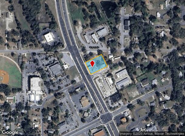
DEMOGRAPHICS near 201 N Us Highway 27/441
1 Mile
3 Mile
5 Mile
2024 Total Population
5,567
32,122
85,872
2029 Population
6,455
38,683
104,586
Pop Growth 2024-2029
+ 15.95%
+ 20.43%
+ 21.79%
Average Age
50
62
63
2024 Total Households
2,713
17,305
45,475
HH Growth 2024-2029
+ 15.63%
+ 20.89%
+ 22.44%
Median Household Inc
$49,600
$54,497
$62,014
Avg Household Size
2.00
1.80
1.90
2024 Avg HH Vehicles
1.00
1.00
1.00
Median Home Value
$98,982
$247,017
$275,736
Median Year Built
1995
1995
2001
Nearby Places
Map Layers
Map Styles
 Street
 Aerial
- Restaurants
- Banks
- Shops
- Fitness
- Groceries
Nearby Properties
Address
Land Use
TOTAL SIZE
Lot Size
Zoning
Address
Land Use
TOTAL SIZE
Lot Size
Zoning
404,584 SF
29.32 AC
MF12
Address
Land Use
TOTAL SIZE
Lot Size
Zoning
344,318 SF
25.73 AC
MF18
Address
Land Use
TOTAL SIZE
Lot Size
Zoning
171,544 SF
15.78 AC
CP
Address
Land Use
TOTAL SIZE
Lot Size
Zoning
182,128 SF
13.25 AC
MF12
Address
Land Use
TOTAL SIZE
Lot Size
Zoning
30,641 SF
103.82 AC
CT
Address
Land Use
TOTAL SIZE
Lot Size
Zoning
165,197 SF
16.74 AC
HC
Address
Land Use
TOTAL SIZE
Lot Size
Zoning
115,531 SF
6.21 AC
MH9
Address
Land Use
TOTAL SIZE
Lot Size
Zoning
94,208 SF
12.72 AC
CP
Address
Land Use
TOTAL SIZE
Lot Size
Zoning
90,064 SF
8.12 AC
A
Address
Land Use
TOTAL SIZE
Lot Size
Zoning
101,064 SF
7.64 AC
CP
Address
Land Use
TOTAL SIZE
Lot Size
Zoning
78,586 SF
1.61 AC
CP
Address
Land Use
TOTAL SIZE
Lot Size
Zoning
29,018 SF
2.43 AC
HC
Address
Land Use
TOTAL SIZE
Lot Size
Zoning
57,545 SF
8.80 AC
Address
Land Use
TOTAL SIZE
Lot Size
Zoning
201,953 SF
19.52 AC
HC
Address
Land Use
TOTAL SIZE
Lot Size
Zoning
91,762 SF
3.24 AC
Address
Land Use
TOTAL SIZE
Lot Size
Zoning
69,101 SF
9.69 AC
CP
Address
Land Use
TOTAL SIZE
Lot Size
Zoning
169,950 SF
18.74 AC
A
Address
Land Use
TOTAL SIZE
Lot Size
Zoning
101,154 SF
19.35 AC
PFD
Address
Land Use
TOTAL SIZE
Lot Size
Zoning
106,910 SF
10.40 AC
CP
Address
Land Use
TOTAL SIZE
Lot Size
Zoning
43,686 SF
1.23 AC
CP
Address
Land Use
TOTAL SIZE
Lot Size
Zoning
67,350 SF
1.52 AC
CP
Address
Land Use
TOTAL SIZE
Lot Size
Zoning
12,456 SF
88.51 AC
C1
Address
Land Use
TOTAL SIZE
Lot Size
Zoning
73,894 SF
2.34 AC
CP
Address
Land Use
TOTAL SIZE
Lot Size
Zoning
77,450 SF
8.97 AC
A
Address
Land Use
TOTAL SIZE
Lot Size
Zoning
72,245 SF
9.97 AC
Address
Land Use
TOTAL SIZE
Lot Size
Zoning
24,570 SF
6.46 AC
Address
Land Use
TOTAL SIZE
Lot Size
Zoning
134,787 SF
22.77 AC
HC
Address
Land Use
TOTAL SIZE
Lot Size
Zoning
51,658 SF
7.39 AC
PUD
Address
Land Use
TOTAL SIZE
Lot Size
Zoning
155,857 SF
10.69 AC
A
Address
Land Use
TOTAL SIZE
Lot Size
Zoning
51,662 SF
13.88 AC
A
The World's #1 Commercial Real Estate Marketplace
Connect with us
© 2025 CoStar Group
The information above has been obtained from sources believed reliable. While we do not doubt its accuracy we have not verified it and make no guarantee, warranty or representation about it. It is your responsibility to independently confirm its accuracy and completeness. Any projections, opinions, assumptions, or estimates used are for example only and do not represent the current or future performance of the property. The value of this transaction to you depends on tax and other factors which should be evaluated by your tax, financial, and legal advisors. You and your advisors should conduct a careful, independent investigation of the property to determine to your satisfaction the suitability of the property for your needs.