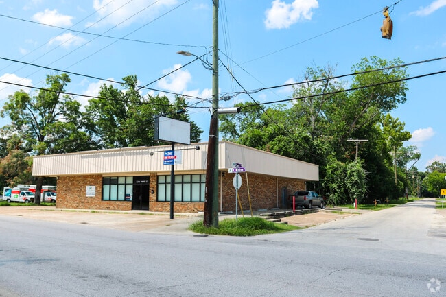
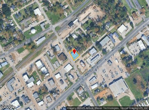
Property Record
201 N Winfree St, Dayton, TX 77535
Current Lease Availabilities
NEARBY LISTINGS FOR SALE OR LEASE
Property Detail
201 N Winfree St
Houston-The Woodlands-Sugar Land, TX
T T L
007810-000010-003
T T L, BLOCK A, LOT 16 17, ACRES .2755
Commercialnec
Liberty
X
Texas
48291C0420D
16
2024
0.28 AC
2025
Liberty County
700802
Houston
4,200 SF
DEMOGRAPHICS near 201 N Winfree St
1 Mile
3 Mile
5 Mile
2024 Total Population
5,343
11,181
23,142
2029 Population
7,043
14,672
29,240
Pop Growth 2024-2029
+ 31.82%
+ 31.22%
+ 26.35%
Average Age
37
37
37
2024 Total Households
1,955
4,094
6,901
HH Growth 2024-2029
+ 30.54%
+ 30.04%
+ 29.85%
Median Household Inc
$58,620
$59,568
$66,014
Avg Household Size
2.70
2.70
2.80
2024 Avg HH Vehicles
2.00
2.00
2.00
Median Home Value
$179,036
$181,097
$194,251
Median Year Built
1994
1996
1998
Nearby Places
- Restaurants
- Banks
- Shops
- Fitness
- Groceries
PUBLIC TRANSPORTATION
AIRPORT
George Bush Intcntl/Houston
DRIVE
WALK
Distance
George Bush Intcntl/Houston
49 min
32.5 mi
Freight Ports
Port of Houston
DRIVE
WALK
Distance
Port of Houston
45 min
34.0 mi
Nearby Properties
Address
Land Use
TOTAL SIZE
Lot Size
Zoning
Address
Land Use
TOTAL SIZE
Lot Size
Zoning
416,683 SF
57.43 AC
Address
Land Use
TOTAL SIZE
Lot Size
Zoning
181,887 SF
32.57 AC
Address
Land Use
TOTAL SIZE
Lot Size
Zoning
125,869 SF
9.20 AC
Address
Land Use
TOTAL SIZE
Lot Size
Zoning
115,523 SF
22.12 AC
Address
Land Use
TOTAL SIZE
Lot Size
Zoning
114,008 SF
2.10 AC
Address
Land Use
TOTAL SIZE
Lot Size
Zoning
16,746 SF
24.30 AC
Address
Land Use
TOTAL SIZE
Lot Size
Zoning
76,953 SF
13.85 AC
Address
Land Use
TOTAL SIZE
Lot Size
Zoning
98,019 SF
10 AC
Address
Land Use
TOTAL SIZE
Lot Size
Zoning
75,945 SF
0.69 AC
Address
Land Use
TOTAL SIZE
Lot Size
Zoning
45,616 SF
14.46 AC
Address
Land Use
TOTAL SIZE
Lot Size
Zoning
140,586 SF
17.62 AC
Address
Land Use
TOTAL SIZE
Lot Size
Zoning
108,096 SF
5.81 AC
Address
Land Use
TOTAL SIZE
Lot Size
Zoning
32,186 SF
2.60 AC
Address
Land Use
TOTAL SIZE
Lot Size
Zoning
55,000 SF
5.53 AC
Address
Land Use
TOTAL SIZE
Lot Size
Zoning
49,350 SF
6.65 AC
Address
Land Use
TOTAL SIZE
Lot Size
Zoning
32.31 AC
Address
Land Use
TOTAL SIZE
Lot Size
Zoning
58,951 SF
5.92 AC
Address
Land Use
TOTAL SIZE
Lot Size
Zoning
50,956 SF
10.03 AC
Address
Land Use
TOTAL SIZE
Lot Size
Zoning
25,170 SF
5.37 AC
Address
Land Use
TOTAL SIZE
Lot Size
Zoning
31,170 SF
0.32 AC
Address
Land Use
TOTAL SIZE
Lot Size
Zoning
25.37 AC
Address
Land Use
TOTAL SIZE
Lot Size
Zoning
6,844 SF
3.25 AC
Address
Land Use
TOTAL SIZE
Lot Size
Zoning
35,486 SF
4.97 AC
Address
Land Use
TOTAL SIZE
Lot Size
Zoning
13,851 SF
3.35 AC
Address
Land Use
TOTAL SIZE
Lot Size
Zoning
11,595 SF
1.60 AC
Address
Land Use
TOTAL SIZE
Lot Size
Zoning
20,396 SF
2 AC
Address
Land Use
TOTAL SIZE
Lot Size
Zoning
20,026 SF
1.95 AC
Address
Land Use
TOTAL SIZE
Lot Size
Zoning
1,625 SF
3 AC
Address
Land Use
TOTAL SIZE
Lot Size
Zoning
20,890 SF
0.96 AC
Address
Land Use
TOTAL SIZE
Lot Size
Zoning
37,897 SF
5.12 AC
The World's #1 Commercial Real Estate Marketplace
Connect with us
© 2025 CoStar Group
The information above has been obtained from sources believed reliable. While we do not doubt its accuracy we have not verified it and make no guarantee, warranty or representation about it. It is your responsibility to independently confirm its accuracy and completeness. Any projections, opinions, assumptions, or estimates used are for example only and do not represent the current or future performance of the property. The value of this transaction to you depends on tax and other factors which should be evaluated by your tax, financial, and legal advisors. You and your advisors should conduct a careful, independent investigation of the property to determine to your satisfaction the suitability of the property for your needs.