Property Record
201 Oakbrook Ln, Summerville, SC 29485
NEARBY LISTINGS FOR SALE OR LEASE
Property Detail
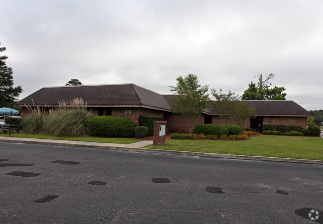
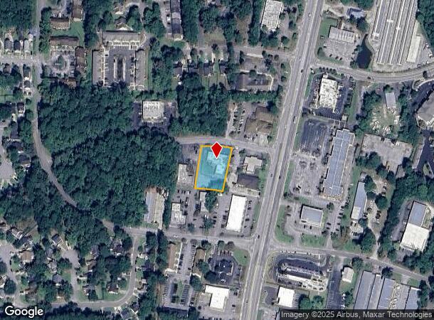
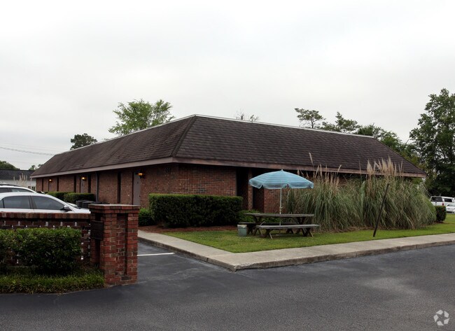
201 Oakbrook Ln
Charleston-North Charleston, SC
Oakbrook Office Park
161-04-01-006
LOT 2 SUBD: OAKBROOK OFFICE PARK PH 0 BLK B
Medicalbuilding
Dorchester
X
South Carolina
45019C0260K
2
2025
0.62 AC
2025
Dorchester County
010808
Charleston/N Charleston
6,031 SF
DEMOGRAPHICS near 201 Oakbrook Ln
1 Mile
3 Mile
5 Mile
2024 Total Population
8,853
59,115
121,019
2029 Population
9,598
63,952
130,873
Pop Growth 2024-2029
+ 8.42%
+ 8.18%
+ 8.14%
Average Age
39
38
38
2024 Total Households
3,605
22,574
46,034
HH Growth 2024-2029
+ 8.35%
+ 8.00%
+ 7.97%
Median Household Inc
$55,795
$72,358
$73,309
Avg Household Size
2.40
2.60
2.60
2024 Avg HH Vehicles
2.00
2.00
2.00
Median Home Value
$230,129
$260,168
$271,170
Median Year Built
1996
2001
1999
Nearby Places
Map Layers
Map Styles
 Street
 Aerial
- Restaurants
- Banks
- Shops
- Fitness
- Groceries
PUBLIC TRANSPORTATION
AIRPORT
Charleston AFB/International
DRIVE
WALK
Distance
Charleston AFB/International
13 min
9.1 mi
SALE & LEASE HISTORY
LISTING DATE
SALE/LEASE

Sep 20, 2018
For Lease
Dec 07, 2022
For Lease
Nearby Properties
Address
Land Use
TOTAL SIZE
Lot Size
Zoning
Address
Land Use
TOTAL SIZE
Lot Size
Zoning
Address
Land Use
TOTAL SIZE
Lot Size
Zoning
124,678 SF
65.93 AC
Address
Land Use
TOTAL SIZE
Lot Size
Zoning
Address
Land Use
TOTAL SIZE
Lot Size
Zoning
276,696 SF
17.87 AC
G-B_SV
Address
Land Use
TOTAL SIZE
Lot Size
Zoning
20,500 SF
1.63 AC
Address
Land Use
TOTAL SIZE
Lot Size
Zoning
299,616 SF
26.90 AC
R-4_DC
Address
Land Use
TOTAL SIZE
Lot Size
Zoning
49.39 AC
PDD_NC
Address
Land Use
TOTAL SIZE
Lot Size
Zoning
3,960 SF
5.51 AC
Address
Land Use
TOTAL SIZE
Lot Size
Zoning
384,000 SF
23.95 AC
PDD_NC
Address
Land Use
TOTAL SIZE
Lot Size
Zoning
236,943 SF
18.74 AC
B-2_NC
Address
Land Use
TOTAL SIZE
Lot Size
Zoning
9,241 SF
9.66 AC
PDD_NC
Address
Land Use
TOTAL SIZE
Lot Size
Zoning
37.71 AC
Address
Land Use
TOTAL SIZE
Lot Size
Zoning
Address
Land Use
TOTAL SIZE
Lot Size
Zoning
339,744 SF
17.75 AC
R-1_NC
Address
Land Use
TOTAL SIZE
Lot Size
Zoning
6,930 SF
4.36 AC
Address
Land Use
TOTAL SIZE
Lot Size
Zoning
102,297 SF
20.14 AC
PDD_NC
Address
Land Use
TOTAL SIZE
Lot Size
Zoning
185,000 SF
28.36 AC
R-2_NC
Address
Land Use
TOTAL SIZE
Lot Size
Zoning
256,996 SF
22.18 AC
R-2_NC
Address
Land Use
TOTAL SIZE
Lot Size
Zoning
20,625 SF
1.43 AC
Address
Land Use
TOTAL SIZE
Lot Size
Zoning
187,640 SF
22.07 AC
MF-R_SV
Address
Land Use
TOTAL SIZE
Lot Size
Zoning
227,472 SF
13.51 AC
MF-R_SV
Address
Land Use
TOTAL SIZE
Lot Size
Zoning
186,798 SF
18.39 AC
MF-R_SV
Address
Land Use
TOTAL SIZE
Lot Size
Zoning
194,616 SF
16.88 AC
PDD_NC
Address
Land Use
TOTAL SIZE
Lot Size
Zoning
3.30 AC
Address
Land Use
TOTAL SIZE
Lot Size
Zoning
21.30 AC
Address
Land Use
TOTAL SIZE
Lot Size
Zoning
229,810 SF
13.43 AC
MF-R_SV
Address
Land Use
TOTAL SIZE
Lot Size
Zoning
104,915 SF
23.92 AC
PDD_NC
Address
Land Use
TOTAL SIZE
Lot Size
Zoning
19.26 AC
Address
Land Use
TOTAL SIZE
Lot Size
Zoning
105,332 SF
10.67 AC
MF-R_SV
Address
Land Use
TOTAL SIZE
Lot Size
Zoning
180,750 SF
7.73 AC
PDD_NC
The World's #1 Commercial Real Estate Marketplace
Connect with us
© 2025 CoStar Group
The information above has been obtained from sources believed reliable. While we do not doubt its accuracy we have not verified it and make no guarantee, warranty or representation about it. It is your responsibility to independently confirm its accuracy and completeness. Any projections, opinions, assumptions, or estimates used are for example only and do not represent the current or future performance of the property. The value of this transaction to you depends on tax and other factors which should be evaluated by your tax, financial, and legal advisors. You and your advisors should conduct a careful, independent investigation of the property to determine to your satisfaction the suitability of the property for your needs.