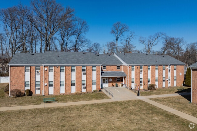
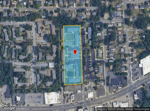
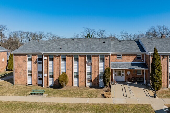
Property Record
201 Oakley Ave, Massapequa, NY 11758
NEARBY LISTINGS FOR SALE OR LEASE
Property Detail
201 Oakley Ave
2489-53-020-00-0019-0
19-74
Governmentalpublicusegeneral
Nassau
X
New York
36103C0841H
19-74
0
3.41 AC
2025
East Massapequa
522000
Long Island (New York)
143,484 SF
Nassau County-Suffolk County, NY
DEMOGRAPHICS near 201 Oakley Ave
1 Mile
3 Mile
5 Mile
2024 Total Population
15,259
127,984
273,175
2029 Population
15,009
125,328
267,436
Pop Growth 2024-2029
(1.64%)
(2.08%)
(2.10%)
Average Age
44
42
42
2024 Total Households
5,568
42,359
91,757
HH Growth 2024-2029
(1.89%)
(2.23%)
(2.25%)
Median Household Inc
$109,316
$115,434
$121,069
Avg Household Size
2.60
2.90
2.90
2024 Avg HH Vehicles
2.00
2.00
2.00
Median Home Value
$595,849
$546,125
$539,674
Median Year Built
1958
1958
1957
Nearby Places
- Restaurants
- Banks
- Shops
- Fitness
- Groceries
PUBLIC TRANSPORTATION
COMMUTER RAIL
Amityville Station (Babylon Branch - Long Island Rail Road)
DRIVE
WALK
Distance
Amityville Station (Babylon Branch - Long Island Rail Road)
3 min
1.2 mi
Massapequa Park Station (Babylon Branch - Long Island Rail Road)
DRIVE
WALK
Distance
Massapequa Park Station (Babylon Branch - Long Island Rail Road)
4 min
2.3 mi
AIRPORT
John F Kennedy International
DRIVE
WALK
Distance
John F Kennedy International
32 min
22.4 mi
Long Island MacArthur
DRIVE
WALK
Distance
Long Island MacArthur
32 min
22.5 mi
LaGuardia
DRIVE
WALK
Distance
LaGuardia
43 min
29.4 mi
Freight Ports
NY - Red Hook Container Terminal
DRIVE
WALK
Distance
NY - Red Hook Container Terminal
53 min
33.8 mi
Nearby Properties
Address
Land Use
TOTAL SIZE
Lot Size
Zoning
Address
Land Use
TOTAL SIZE
Lot Size
Zoning
12,920 SF
1.90 AC
R60
Address
Land Use
TOTAL SIZE
Lot Size
Zoning
9.95 AC
BUS3
Address
Land Use
TOTAL SIZE
Lot Size
Zoning
163.85 AC
Address
Land Use
TOTAL SIZE
Lot Size
Zoning
892,140 SF
31.82 AC
Address
Land Use
TOTAL SIZE
Lot Size
Zoning
24.90 AC
B
Address
Land Use
TOTAL SIZE
Lot Size
Zoning
3,518 SF
0.44 AC
VILLA
Address
Land Use
TOTAL SIZE
Lot Size
Zoning
2,520 SF
0.89 AC
HC
Address
Land Use
TOTAL SIZE
Lot Size
Zoning
1.70 AC
R40
Address
Land Use
TOTAL SIZE
Lot Size
Zoning
Address
Land Use
TOTAL SIZE
Lot Size
Zoning
119,692 SF
24.59 AC
Address
Land Use
TOTAL SIZE
Lot Size
Zoning
Address
Land Use
TOTAL SIZE
Lot Size
Zoning
22.10 AC
Address
Land Use
TOTAL SIZE
Lot Size
Zoning
0.99 AC
HB
Address
Land Use
TOTAL SIZE
Lot Size
Zoning
0.90 AC
HC
Address
Land Use
TOTAL SIZE
Lot Size
Zoning
17,305 SF
51.61 AC
Address
Land Use
TOTAL SIZE
Lot Size
Zoning
7.15 AC
Address
Land Use
TOTAL SIZE
Lot Size
Zoning
6,891 SF
0.75 AC
HC
Address
Land Use
TOTAL SIZE
Lot Size
Zoning
1,500 SF
125.69 AC
Address
Land Use
TOTAL SIZE
Lot Size
Zoning
13.63 AC
B
Address
Land Use
TOTAL SIZE
Lot Size
Zoning
205,948 SF
15.21 AC
Address
Land Use
TOTAL SIZE
Lot Size
Zoning
68,555 SF
20.14 AC
Address
Land Use
TOTAL SIZE
Lot Size
Zoning
3,700 SF
43.04 AC
Address
Land Use
TOTAL SIZE
Lot Size
Zoning
136,804 SF
10.56 AC
Address
Land Use
TOTAL SIZE
Lot Size
Zoning
9.68 AC
SC
Address
Land Use
TOTAL SIZE
Lot Size
Zoning
0.76 AC
HD
Address
Land Use
TOTAL SIZE
Lot Size
Zoning
0.46 AC
R40
Address
Land Use
TOTAL SIZE
Lot Size
Zoning
97,594 SF
13.53 AC
Address
Land Use
TOTAL SIZE
Lot Size
Zoning
1.70 AC
R60
Address
Land Use
TOTAL SIZE
Lot Size
Zoning
49,004 SF
13.34 AC
Address
Land Use
TOTAL SIZE
Lot Size
Zoning
141,729 SF
9.23 AC
The World's #1 Commercial Real Estate Marketplace
Connect with us
© 2025 CoStar Group
The information above has been obtained from sources believed reliable. While we do not doubt its accuracy we have not verified it and make no guarantee, warranty or representation about it. It is your responsibility to independently confirm its accuracy and completeness. Any projections, opinions, assumptions, or estimates used are for example only and do not represent the current or future performance of the property. The value of this transaction to you depends on tax and other factors which should be evaluated by your tax, financial, and legal advisors. You and your advisors should conduct a careful, independent investigation of the property to determine to your satisfaction the suitability of the property for your needs.