Property Record
69 Pacolet St, Tryon, NC 28782
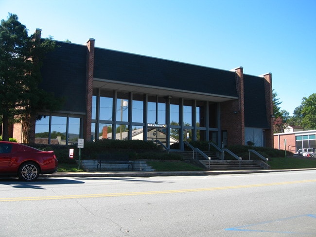

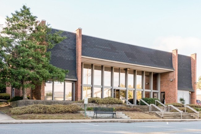
Property Detail
69 Pacolet St
Officebuilding
T11A, 0T81 TRYON AREA 81
M
Polk
B and X Area of moderate flood hazard, usually the area between the limits of the 100-year and 500-year floods.
North Carolina
2025
0.68 AC
2025
North Carolina West/Cherokee Area
920304
Other Market Areas
5,360 SF
T11-D5
NEARBY LISTINGS FOR SALE OR LEASE
DEMOGRAPHICS near 69 Pacolet St
1 mile
3 mile
5 mile
2025 Total Population
2,097
6,629
14,239
2030 Population
2,204
7,011
15,284
Pop Growth 2025-2030
+ 5.10%
+ 5.76%
+ 7.34%
Average Age
53
51
49
2025 Total Households
1,088
3,106
6,425
HH Growth 2025-2030
+ 5.06%
+ 5.70%
+ 7.30%
Median Household Inc
$56,306
$62,625
$61,663
Avg Household Size
1.90
2.10
2.10
2025 Avg HH Vehicles
2.00
2.00
2.00
Median Home Value
$283,040
$329,629
$300,654
Median Year Built
1976
1979
1980
Nearby Places
Map Layers
Map Styles
 Street
 Aerial
Transit
 Traffic
 Biking
Places
Listings with unknown addresses are not visible on the map
- Restaurants
- Banks
- Shops
- Fitness
- Groceries
PUBLIC TRANSPORTATION
AIRPORT
Greenville Spartanburg International
Drive
Walk
Distance
Greenville Spartanburg International
43 min
25.0 mi
Asheville Regional
Drive
Walk
Distance
Asheville Regional
43 min
30.9 mi
SALE & LEASE HISTORY
LISTING DATE
SALE/LEASE

Sep 25, 2023
For Lease
Sep 25, 2016
For Lease
Oct 26, 2016
For Sale
Oct 26, 2016
For Sale
Jul 07, 2021
For Sale
Dec 21, 2016
For Sale
Dec 15, 2016
For Sale
Dec 15, 2016
For Sale
Nearby Properties
Address
Land Use
TOTAL SIZE
Lot Size
Zoning
Address
Land Use
TOTAL SIZE
Lot Size
Zoning
68,155 SF
63.56 AC
MX
Address
Land Use
TOTAL SIZE
Lot Size
Zoning
92,600 SF
15.84 AC
MX
Address
Land Use
TOTAL SIZE
Lot Size
Zoning
13 AC
M
Address
Land Use
TOTAL SIZE
Lot Size
Zoning
450.29 AC
Address
Land Use
TOTAL SIZE
Lot Size
Zoning
16,744 SF
7.58 AC
M
Address
Land Use
TOTAL SIZE
Lot Size
Zoning
8,095 SF
0.53 AC
M
Address
Land Use
TOTAL SIZE
Lot Size
Zoning
14,926 SF
4.48 AC
M
Address
Land Use
TOTAL SIZE
Lot Size
Zoning
289.30 AC
UNZONED
Address
Land Use
TOTAL SIZE
Lot Size
Zoning
6,735 SF
8.20 AC
M
Address
Land Use
TOTAL SIZE
Lot Size
Zoning
15,450 SF
3 AC
M
Address
Land Use
TOTAL SIZE
Lot Size
Zoning
2,796 SF
7.95 AC
M
Address
Land Use
TOTAL SIZE
Lot Size
Zoning
8,986 SF
1.15 AC
M
Address
Land Use
TOTAL SIZE
Lot Size
Zoning
7,204 SF
5.25 AC
M
Address
Land Use
TOTAL SIZE
Lot Size
Zoning
6,688 SF
1.25 AC
M
Address
Land Use
TOTAL SIZE
Lot Size
Zoning
4,368 SF
3.71 AC
M
Address
Land Use
TOTAL SIZE
Lot Size
Zoning
28.12 AC
M
Address
Land Use
TOTAL SIZE
Lot Size
Zoning
318.36 AC
MX
Address
Land Use
TOTAL SIZE
Lot Size
Zoning
7,316 SF
3.01 AC
M
Address
Land Use
TOTAL SIZE
Lot Size
Zoning
6,443 SF
0.72 AC
M
Address
Land Use
TOTAL SIZE
Lot Size
Zoning
4,635 SF
2.49 AC
M
Address
Land Use
TOTAL SIZE
Lot Size
Zoning
4,432 SF
8.05 AC
M
Address
Land Use
TOTAL SIZE
Lot Size
Zoning
93.70 AC
UNZONED
Address
Land Use
TOTAL SIZE
Lot Size
Zoning
122.29 AC
MX
Address
Land Use
TOTAL SIZE
Lot Size
Zoning
10,000 SF
10.63 AC
M
Address
Land Use
TOTAL SIZE
Lot Size
Zoning
2,125 SF
6.17 AC
M
Address
Land Use
TOTAL SIZE
Lot Size
Zoning
220 AC
MX
Address
Land Use
TOTAL SIZE
Lot Size
Zoning
2,334 SF
126.27 AC
M
Address
Land Use
TOTAL SIZE
Lot Size
Zoning
16,552 SF
2.15 AC
M
Address
Land Use
TOTAL SIZE
Lot Size
Zoning
3,304 SF
0.74 AC
M
Address
Land Use
TOTAL SIZE
Lot Size
Zoning
33.88 AC
MX
The World's #1 Commercial Real Estate Marketplace
Connect with us
© 2026 CoStar Group
The information above has been obtained from sources believed reliable. While we do not doubt its accuracy we have not verified it and make no guarantee, warranty or representation about it. It is your responsibility to independently confirm its accuracy and completeness. Any projections, opinions, assumptions, or estimates used are for example only and do not represent the current or future performance of the property. The value of this transaction to you depends on tax and other factors which should be evaluated by your tax, financial, and legal advisors. You and your advisors should conduct a careful, independent investigation of the property to determine to your satisfaction the suitability of the property for your needs.