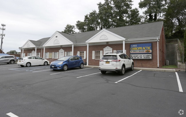
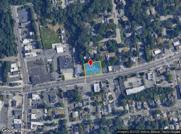
Property Record
201 Portion Rd, Ronkonkoma, NY 11779

Current Lease Availabilities
NEARBY LISTINGS FOR SALE OR LEASE
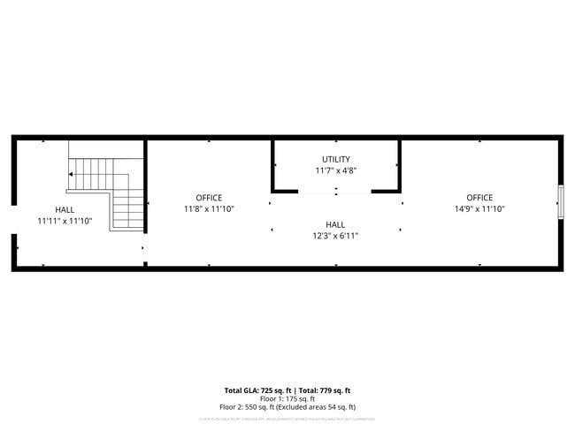
Property Detail
201 Portion Rd
Nassau County-Suffolk County, NY
HOLLYWOOD HGTS 686 E PT 39 ALL 40&4
0200-689-00-02-00-021-008
Suffolk
Commercialbuilding
New York
X
21
36103C0680H
0.51 AC
2024
Central Suffolk
2024
Long Island (New York)
158608
DEMOGRAPHICS near 201 Portion Rd
1 Mile
3 Mile
5 Mile
2024 Total Population
11,397
89,283
227,486
2029 Population
11,161
87,821
224,035
Pop Growth 2024-2029
(2.07%)
(1.64%)
(1.52%)
Average Age
42
41
41
2024 Total Households
4,074
29,746
76,526
HH Growth 2024-2029
(2.31%)
(1.80%)
(1.70%)
Median Household Inc
$85,387
$119,569
$120,897
Avg Household Size
2.60
2.90
2.90
2024 Avg HH Vehicles
2.00
2.00
2.00
Median Home Value
$399,850
$457,359
$464,227
Median Year Built
1965
1970
1970
Nearby Places
- Restaurants
- Banks
- Shops
- Fitness
- Groceries
PUBLIC TRANSPORTATION
COMMUTER RAIL
Ronkonkoma Station (Greenport Branch - Long Island Rail Road, Ronkonkoma Branch - Long Island Rail Road)
DRIVE
WALK
Distance
Ronkonkoma Station (Greenport Branch - Long Island Rail Road, Ronkonkoma Branch - Long Island Rail Road)
6 min
2.4 mi
St James Station (Port Jefferson Branch - Long Island Rail Road)
DRIVE
WALK
Distance
St James Station (Port Jefferson Branch - Long Island Rail Road)
14 min
5.5 mi
AIRPORT
Long Island MacArthur
DRIVE
WALK
Distance
Long Island MacArthur
11 min
4.6 mi
Freight Ports
Port of New Haven
DRIVE
WALK
Distance
Port of New Haven
128 min
48.3 mi
Nearby Properties
Address
Land Use
TOTAL SIZE
Lot Size
Zoning
Address
Land Use
TOTAL SIZE
Lot Size
Zoning
1,207.60 AC
Address
Land Use
TOTAL SIZE
Lot Size
Zoning
49.54 AC
CA
Address
Land Use
TOTAL SIZE
Lot Size
Zoning
95.19 AC
Address
Land Use
TOTAL SIZE
Lot Size
Zoning
51.59 AC
AA
Address
Land Use
TOTAL SIZE
Lot Size
Zoning
23.50 AC
AA
Address
Land Use
TOTAL SIZE
Lot Size
Zoning
23.08 AC
AA
Address
Land Use
TOTAL SIZE
Lot Size
Zoning
140.10 AC
Address
Land Use
TOTAL SIZE
Lot Size
Zoning
5.40 AC
ICD
Address
Land Use
TOTAL SIZE
Lot Size
Zoning
6.50 AC
GSE
Address
Land Use
TOTAL SIZE
Lot Size
Zoning
Address
Land Use
TOTAL SIZE
Lot Size
Zoning
15.80 AC
ICD
Address
Land Use
TOTAL SIZE
Lot Size
Zoning
12.20 AC
IND1
Address
Land Use
TOTAL SIZE
Lot Size
Zoning
10.99 AC
Address
Land Use
TOTAL SIZE
Lot Size
Zoning
6,486 SF
0.55 AC
VILLA
Address
Land Use
TOTAL SIZE
Lot Size
Zoning
12.12 AC
IND1
Address
Land Use
TOTAL SIZE
Lot Size
Zoning
16.30 AC
Address
Land Use
TOTAL SIZE
Lot Size
Zoning
8.67 AC
IND1
Address
Land Use
TOTAL SIZE
Lot Size
Zoning
6.12 AC
AA
Address
Land Use
TOTAL SIZE
Lot Size
Zoning
2.31 AC
IND1
Address
Land Use
TOTAL SIZE
Lot Size
Zoning
0.55 AC
VILLA
Address
Land Use
TOTAL SIZE
Lot Size
Zoning
7.33 AC
Address
Land Use
TOTAL SIZE
Lot Size
Zoning
10.60 AC
A
Address
Land Use
TOTAL SIZE
Lot Size
Zoning
32.41 AC
AA
Address
Land Use
TOTAL SIZE
Lot Size
Zoning
9.30 AC
IND1
Address
Land Use
TOTAL SIZE
Lot Size
Zoning
21.20 AC
AA
Address
Land Use
TOTAL SIZE
Lot Size
Zoning
6 AC
IND1
Address
Land Use
TOTAL SIZE
Lot Size
Zoning
3.50 AC
IND1
Address
Land Use
TOTAL SIZE
Lot Size
Zoning
0.49 AC
VILLA
Address
Land Use
TOTAL SIZE
Lot Size
Zoning
17.76 AC
Address
Land Use
TOTAL SIZE
Lot Size
Zoning
3.85 AC
IND1
The World's #1 Commercial Real Estate Marketplace
Connect with us
© 2025 CoStar Group
The information above has been obtained from sources believed reliable. While we do not doubt its accuracy we have not verified it and make no guarantee, warranty or representation about it. It is your responsibility to independently confirm its accuracy and completeness. Any projections, opinions, assumptions, or estimates used are for example only and do not represent the current or future performance of the property. The value of this transaction to you depends on tax and other factors which should be evaluated by your tax, financial, and legal advisors. You and your advisors should conduct a careful, independent investigation of the property to determine to your satisfaction the suitability of the property for your needs.