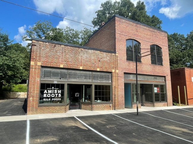
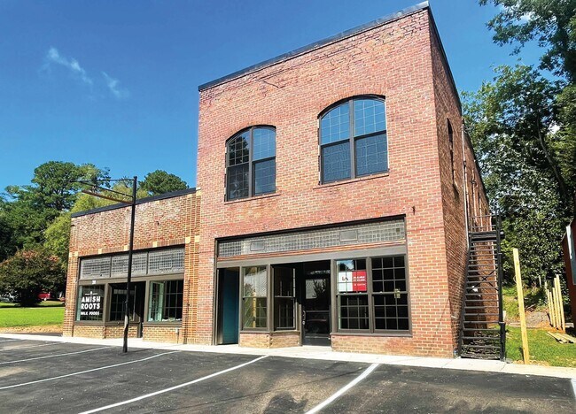
Property Record
201 Post Office Rd, Moncure, NC 27559

Current Lease Availabilities
Property Detail
201 Post Office Rd
62857
LOT 56 AC 0.084 BK 2021 PG 300
Storebuilding
CHATHAM
B-1
North Carolina
B and X Area of moderate flood hazard, usually the area between the limits of the 100-year and 500-year floods.
56
2025
0.08 AC
2025
Chatham County
020702
Raleigh/Durham
1,440 SF
Durham-Chapel Hill, NC
NEARBY LISTINGS FOR SALE OR LEASE
-
-
View all Moncure listings for lease on LoopNet.com
DEMOGRAPHICS near 201 Post Office Rd
1 mile
3 mile
5 mile
2025 Total Population
698
2,092
4,813
2030 Population
756
2,278
5,259
Pop Growth 2025-2030
+ 8.31%
+ 8.89%
+ 9.27%
Average Age
45
44
44
2025 Total Households
279
820
1,887
HH Growth 2025-2030
+ 8.24%
+ 9.02%
+ 9.49%
Median Household Inc
$57,287
$58,481
$62,514
Avg Household Size
2.50
2.50
2.50
2025 Avg HH Vehicles
2.00
2.00
2.00
Median Home Value
$396,077
$340,157
$330,185
Median Year Built
1994
1992
1991
Nearby Places
Map Layers
Map Styles
 Street
 Aerial
Transit
 Traffic
 Biking
Places
Listings with unknown addresses are not visible on the map
- Restaurants
- Banks
- Shops
- Fitness
- Groceries
PUBLIC TRANSPORTATION
AIRPORT
Raleigh-Durham International
Drive
Walk
Distance
Raleigh-Durham International
41 min
32.1 mi
Freight Ports
Port of Wilmington
Drive
Walk
Distance
Port of Wilmington
183 min
160.4 mi
Nearby Properties
Address
Land Use
TOTAL SIZE
Lot Size
Zoning
Address
Land Use
TOTAL SIZE
Lot Size
Zoning
338,013 SF
58.10 AC
IND-H
Address
Land Use
TOTAL SIZE
Lot Size
Zoning
280,718 SF
296.13 AC
IND-H
Address
Land Use
TOTAL SIZE
Lot Size
Zoning
855.31 AC
IND-H
Address
Land Use
TOTAL SIZE
Lot Size
Zoning
252,798 SF
103.69 AC
IND-H
Address
Land Use
TOTAL SIZE
Lot Size
Zoning
38,640 SF
38.35 AC
CD-CB
Address
Land Use
TOTAL SIZE
Lot Size
Zoning
742.44 AC
R-1
Address
Land Use
TOTAL SIZE
Lot Size
Zoning
1,264 SF
483.06 AC
IND-H
Address
Land Use
TOTAL SIZE
Lot Size
Zoning
181,419 SF
107.89 AC
IND-H
Address
Land Use
TOTAL SIZE
Lot Size
Zoning
1,680 SF
248.32 AC
HEAVY INDU
Address
Land Use
TOTAL SIZE
Lot Size
Zoning
151.61 AC
R-1
Address
Land Use
TOTAL SIZE
Lot Size
Zoning
11,928 SF
28.69 AC
IND-H
Address
Land Use
TOTAL SIZE
Lot Size
Zoning
386.12 AC
RESIDENTIA
Address
Land Use
TOTAL SIZE
Lot Size
Zoning
5,602 SF
22.14 AC
CU-OI
Address
Land Use
TOTAL SIZE
Lot Size
Zoning
13,600 SF
10.01 AC
B-1
Address
Land Use
TOTAL SIZE
Lot Size
Zoning
14,283 SF
4 AC
OI
Address
Land Use
TOTAL SIZE
Lot Size
Zoning
4,266 SF
6.60 AC
R-1
Address
Land Use
TOTAL SIZE
Lot Size
Zoning
868 SF
193.41 AC
R-1
Address
Land Use
TOTAL SIZE
Lot Size
Zoning
720 SF
33.75 AC
HEAVY INDU
Address
Land Use
TOTAL SIZE
Lot Size
Zoning
4,834 SF
8.30 AC
OI
Address
Land Use
TOTAL SIZE
Lot Size
Zoning
735 SF
274.62 AC
RESIDENTIA
Address
Land Use
TOTAL SIZE
Lot Size
Zoning
6,091 SF
1.97 AC
NB
Address
Land Use
TOTAL SIZE
Lot Size
Zoning
1,428 SF
10.35 AC
CU-B-1
Address
Land Use
TOTAL SIZE
Lot Size
Zoning
65.23 AC
R-1
Address
Land Use
TOTAL SIZE
Lot Size
Zoning
12.30 AC
R-1
Address
Land Use
TOTAL SIZE
Lot Size
Zoning
4,952 SF
28.19 AC
R-1
Address
Land Use
TOTAL SIZE
Lot Size
Zoning
2,726 SF
159.88 AC
RESIDENTIA
Address
Land Use
TOTAL SIZE
Lot Size
Zoning
212.56 AC
RESIDENTIA
Address
Land Use
TOTAL SIZE
Lot Size
Zoning
99.41 AC
HEAVY INDU
Address
Land Use
TOTAL SIZE
Lot Size
Zoning
74.71 AC
IND-H
Address
Land Use
TOTAL SIZE
Lot Size
Zoning
49.08 AC
R-1
The World's #1 Commercial Real Estate Marketplace
Connect with us
© 2026 CoStar Group
The information above has been obtained from sources believed reliable. While we do not doubt its accuracy we have not verified it and make no guarantee, warranty or representation about it. It is your responsibility to independently confirm its accuracy and completeness. Any projections, opinions, assumptions, or estimates used are for example only and do not represent the current or future performance of the property. The value of this transaction to you depends on tax and other factors which should be evaluated by your tax, financial, and legal advisors. You and your advisors should conduct a careful, independent investigation of the property to determine to your satisfaction the suitability of the property for your needs.