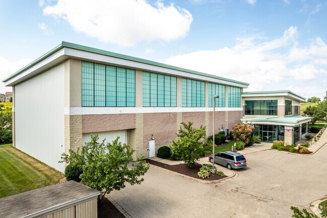
Property Record
201 Prairie Heights Dr, Verona, WI 53593

NEARBY LISTINGS FOR SALE OR LEASE
-
-
View all Verona listings for sale on LoopNet.com
Property Detail
201 Prairie Heights Dr
Madison, WI
Certified Surv Map 11303
0608-224-9375-2
LOT 1 CSM 11303 CS68/198-200 01-14-05 DESCR AS SEC 22-06-08 PRT OF SE1/4 SW1/4 & PRT SW1/4 SE1/4 F/K/A LOT 2 & PRT LOT 3 CSM 9171 CS51/295&299-1/12/99 DESCR AS SEC 22-6-8 PRT NE1/4SE1/4, PRT SE1/4SE1/4 & PRT SW1/4SE1/4 (2.295 ACRE)
Commercialnec
Dane
X
Wisconsin
55025C0557G
1
2024
2.30 AC
2024
Outlying Dane West
013700
Milwaukee/Madison
DEMOGRAPHICS near 201 Prairie Heights Dr
1 Mile
3 Mile
5 Mile
2024 Total Population
5,625
20,629
60,213
2029 Population
5,885
21,560
62,536
Pop Growth 2024-2029
+ 4.62%
+ 4.51%
+ 3.86%
Average Age
36
38
38
2024 Total Households
2,185
8,200
24,623
HH Growth 2024-2029
+ 4.81%
+ 4.71%
+ 3.98%
Median Household Inc
$87,216
$106,014
$99,560
Avg Household Size
2.50
2.50
2.40
2024 Avg HH Vehicles
2.00
2.00
2.00
Median Home Value
$364,217
$363,276
$351,816
Median Year Built
2004
2001
1996
Nearby Places
Map Layers
Map Styles
 Street
 Aerial
- Restaurants
- Banks
- Shops
- Fitness
- Groceries
PUBLIC TRANSPORTATION
AIRPORT
Dane County Regional/Truax Field
DRIVE
WALK
Distance
Dane County Regional/Truax Field
32 min
16.6 mi
Freight Ports
Port Milwaukee
DRIVE
WALK
Distance
Port Milwaukee
113 min
93.3 mi
SALE & LEASE HISTORY
LISTING DATE
SALE/LEASE

Feb 17, 2022
For Sale
Aug 29, 2024
For Sale
Apr 15, 2021
For Sale
Nearby Properties
Address
Land Use
TOTAL SIZE
Lot Size
Zoning
Address
Land Use
TOTAL SIZE
Lot Size
Zoning
13.06 AC
Address
Land Use
TOTAL SIZE
Lot Size
Zoning
77,296 SF
4.84 AC
TR-U1
Address
Land Use
TOTAL SIZE
Lot Size
Zoning
18,242 SF
4.45 AC
TR-U1
Address
Land Use
TOTAL SIZE
Lot Size
Zoning
Address
Land Use
TOTAL SIZE
Lot Size
Zoning
3.35 AC
Address
Land Use
TOTAL SIZE
Lot Size
Zoning
2.76 AC
Address
Land Use
TOTAL SIZE
Lot Size
Zoning
5.58 AC
Address
Land Use
TOTAL SIZE
Lot Size
Zoning
3.56 AC
Address
Land Use
TOTAL SIZE
Lot Size
Zoning
3.96 AC
Address
Land Use
TOTAL SIZE
Lot Size
Zoning
17.81 AC
Address
Land Use
TOTAL SIZE
Lot Size
Zoning
3.71 AC
Address
Land Use
TOTAL SIZE
Lot Size
Zoning
6.66 AC
Address
Land Use
TOTAL SIZE
Lot Size
Zoning
5.23 AC
Address
Land Use
TOTAL SIZE
Lot Size
Zoning
20,787 SF
4.56 AC
TR-U1
Address
Land Use
TOTAL SIZE
Lot Size
Zoning
3.62 AC
Address
Land Use
TOTAL SIZE
Lot Size
Zoning
7.77 AC
Address
Land Use
TOTAL SIZE
Lot Size
Zoning
6.32 AC
Address
Land Use
TOTAL SIZE
Lot Size
Zoning
3.12 AC
Address
Land Use
TOTAL SIZE
Lot Size
Zoning
13.43 AC
Address
Land Use
TOTAL SIZE
Lot Size
Zoning
5.77 AC
Address
Land Use
TOTAL SIZE
Lot Size
Zoning
5.17 AC
Address
Land Use
TOTAL SIZE
Lot Size
Zoning
Address
Land Use
TOTAL SIZE
Lot Size
Zoning
56,146 SF
1.33 AC
PD
Address
Land Use
TOTAL SIZE
Lot Size
Zoning
79,759 SF
1.15 AC
PD
Address
Land Use
TOTAL SIZE
Lot Size
Zoning
1.10 AC
Address
Land Use
TOTAL SIZE
Lot Size
Zoning
1.08 AC
Address
Land Use
TOTAL SIZE
Lot Size
Zoning
2.16 AC
Address
Land Use
TOTAL SIZE
Lot Size
Zoning
11.41 AC
Address
Land Use
TOTAL SIZE
Lot Size
Zoning
1.90 AC
Address
Land Use
TOTAL SIZE
Lot Size
Zoning
7.17 AC
The World's #1 Commercial Real Estate Marketplace
Connect with us
© 2026 CoStar Group
The information above has been obtained from sources believed reliable. While we do not doubt its accuracy we have not verified it and make no guarantee, warranty or representation about it. It is your responsibility to independently confirm its accuracy and completeness. Any projections, opinions, assumptions, or estimates used are for example only and do not represent the current or future performance of the property. The value of this transaction to you depends on tax and other factors which should be evaluated by your tax, financial, and legal advisors. You and your advisors should conduct a careful, independent investigation of the property to determine to your satisfaction the suitability of the property for your needs.